
|
|
|
During September of 2000, DCSki’s Editor loaded his car up and headed west, with no fixed agenda - just a yearning for some adventure and fun.
|
|
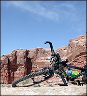
Like peanut butter and chocolate. A match made in heaven: the fat tires of a mountain bike and endless trails available in the Moab area. Photo by M. Scott Smith.
|
Two syllables will flow freely off the tongues of die-hard mountain bikers: Moab (pronounced “Moe-ab”). The small town in Utah (outside of Salt Lake City, every town in Utah is small) offers a dream environment for mountain bikers: hundreds of miles of challenging trails, incredible scenery, and a riding surface known as slickrock. Slickrock is like powder skiing: it’s something you have to experience to fully appreciate, and once you do, you’ll crave it every time you’re on the “other stuff” (frozen granular for skiing or asphalt for mountain biking).
The point I’m trying to make is that mountain biking in Moab is pretty cool.
Actually, it’s pretty hot. Especially in mid-summer, when daytime temperatures can climb above 100. Looking for shade? There isn’t much.
The best time to visit Moab is during the fall, so, with perfect timing, after spending a couple days in Breckenridge, Colorado, I headed west past resorts such as Copper Mountain and Vail, descending the western range of Colorado until hitting Utah. From there, I continued on I-70 to 191, which heads south to Moab. Arches National Park is located three miles north of Moab on 191; Canyonlands National Park is west of Moab.
As in Colorado, temperatures in Moab were higher than normal, with daytime highs in the upper 80’s. (A few days later, a cold front would drop temperatures in Colorado and Utah and even bring snow to the higher elevations.)
After arriving in the Moab region in the evening, my task was to find a campsite. A popular campground in Arches National Park fills up daily every morning; knowing this, I headed straight to some Bureau of Land Management (BLM) primitive campsites I had stayed at previously along the Colorado River, in between Arches and Moab. These primitive campsites share a canyon with the Colorado River, which starts out as crystal-clear water in the high Rockies but is chocolately-muddy by the time it carves its way through Utah.
|
|
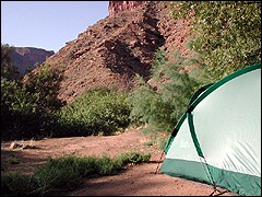
Camping on the Colorado. Dozens of primitive BLM camping sites line the Colorado River in a canyon just south of Arches National Park. Photo by M. Scott Smith.
|
During my last visit to this canyon, I enjoyed camping under the stars - thousands of them - as a bright moon rose. The moon was so bright it cast a shadow. Unfortunately, during this visit, the sky was overcast - letting out occasional mists of rain - and the night show I had looked forward to was thus postponed until later during the trip. The clouds also kept some of the ground heat from escaping into space, keeping early night temperatures a couple degrees too warm for my comfort. Thus, I alternated between opening my tent’s windows to let in a breeze, to closing them when a few drops of rain started to fall.
The next morning, I woke up with a stiff neck, and began to wonder what it was exactly about camping that I enjoyed so much, staring at a sand- and dust-covered tent. On top of the disappointment of not seeing stars the night before, a couple arrived in the campsite next to mine around dusk, bickering among themselves as they detached a pull-along trailer from their truck. They proceeded to fire up a generator, which let out a loud roar less than 12 feet from my tent for the next two hours.
It’s funny how quickly good memories can be replaced. I had looked forward to camping in this canyon since I was last there, two years ago.
|
|
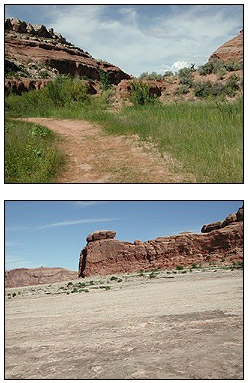
Nice selection. The Monitor and Merrimack trail covers a wide variety of terrain: dirt jeep trails, singletrack, and, of course, unadulterated slickrock. Photos by M. Scott Smith.
|
I now looked forward to checking into a hotel. There’s always one thing you can say in favor of hotel rooms: they have plumbing. (Primitive campsites do not.)
Thus I checked into the nearby Aarchway Inn, a great new hotel that has (a) plumbing, (b) a ceiling fan in each room, and (c) air conditioning! To my surprise, I was able to check in at 10 a.m. in the morning, and immediately took a shower and planned the rest of my day.
My plan for the day: go mountain biking for a few hours, grab dinner, and then head to Arches National Park for some sunset photography. (Colors in the region explode into vibrant reds and oranges during sunrise and sunset, making for some great pictures.)
My actual day: went mountain biking for a few hours, grabbed dinner, collapsed at hotel. (Did I mention the hotel had air conditioning? I can’t stress how good this feels when you’ve been exercising in the hot desert sun for hours.)
My mountain biking adventure took me to a familiar trail: the Monitor & Merrimack, a trail I wrote about on DCSki during my past visit to Utah. The Slickrock trail, a separate trail, is perhaps the most famous trail in the region, but it attracts crowds and is rated expert. (A rating I myself do not share.) The Monitor & Merrimack trail provides a taste of everything great in Utah: plenty of slickrock, of course, but also gutted jeep trails, singletrack through a grass prairie that comes alive during rainstorms, and even a tour through ruins from the 19th century and dinosaur fossils from the distant past.
Not bad for a loop that can be covered in several hours.
The trailhead for this trail is also hidden; it’s not uncommon to have the trail all to yourself. Which means seeing great scenery for dozens of miles in each direction - but little wildlife beyond an occasional bird or a lizard scurrying across the slickrock.
|
|
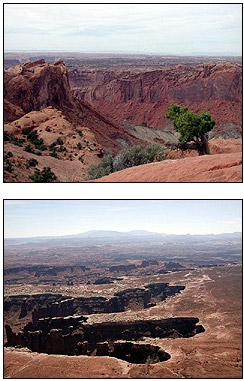
Canyonlands. Although geographically close to Arches National Park, Canyonlands National Park offers a distinctly different experience. Photos by M. Scott Smith.
|
Day two in Moab. My plan for the day: spend several hours in Canyonlands National Park, grab dinner, and then head to Arches for some sunset photography (take two).
My actual day: Went to Canyonlands for most of the day, grabbed dinner, collapsed at hotel.
So much for Arches this trip. Thankfully, I have been to Arches National Park during several past trips; I strongly recommend it.
I had never been to Canyonlands, which is one of the more remote national parks in the continental United States. Like the Grand Canyon, there are distinct northern and southern sections of the Park, and they’re not connected directly by pavement; you have to drive a few hours (or more) to get from one part to the other. The northern part of Canyonlands (“Island in the Sky”) is accessible via a road just north of Moab; that was my destination for the day.
A paved road winds around the top of a large mesa; from it, plenty of hiking trails and jeep trails branch off.
If you are afraid of heights, this might not be the Park for you. The edges of the mesa drop off - sharply - into canyons thousands of feet below. From the rim you can view the result of millions of yeas of erosion, which have eaten away at the rock, leaving catacombs and all kinds of interesting rock formations. Just south of here the Green River and Colorado River converge into one; you can’t actually see the rivers from this vantage point, but you can see the tops of the deep canyons they have carved.
My favorite hike at Canyonlands was to the top of Whale Rock, a huge glob of solid rock. A trail scrambles to the top, giving the hiker a 360-degree panorama of a surreal and, at times, utterly quiet landscape. Any hike in this area is a 3-dimensional adventure.
Next stop: Las Vegas, Nevada.
Tips for visiting the Moab region:
M. Scott Smith is the founder and Editor of DCSki. Scott loves outdoor activities such as camping, hiking, kayaking, skiing, and mountain biking. He is an avid photographer and writer.