
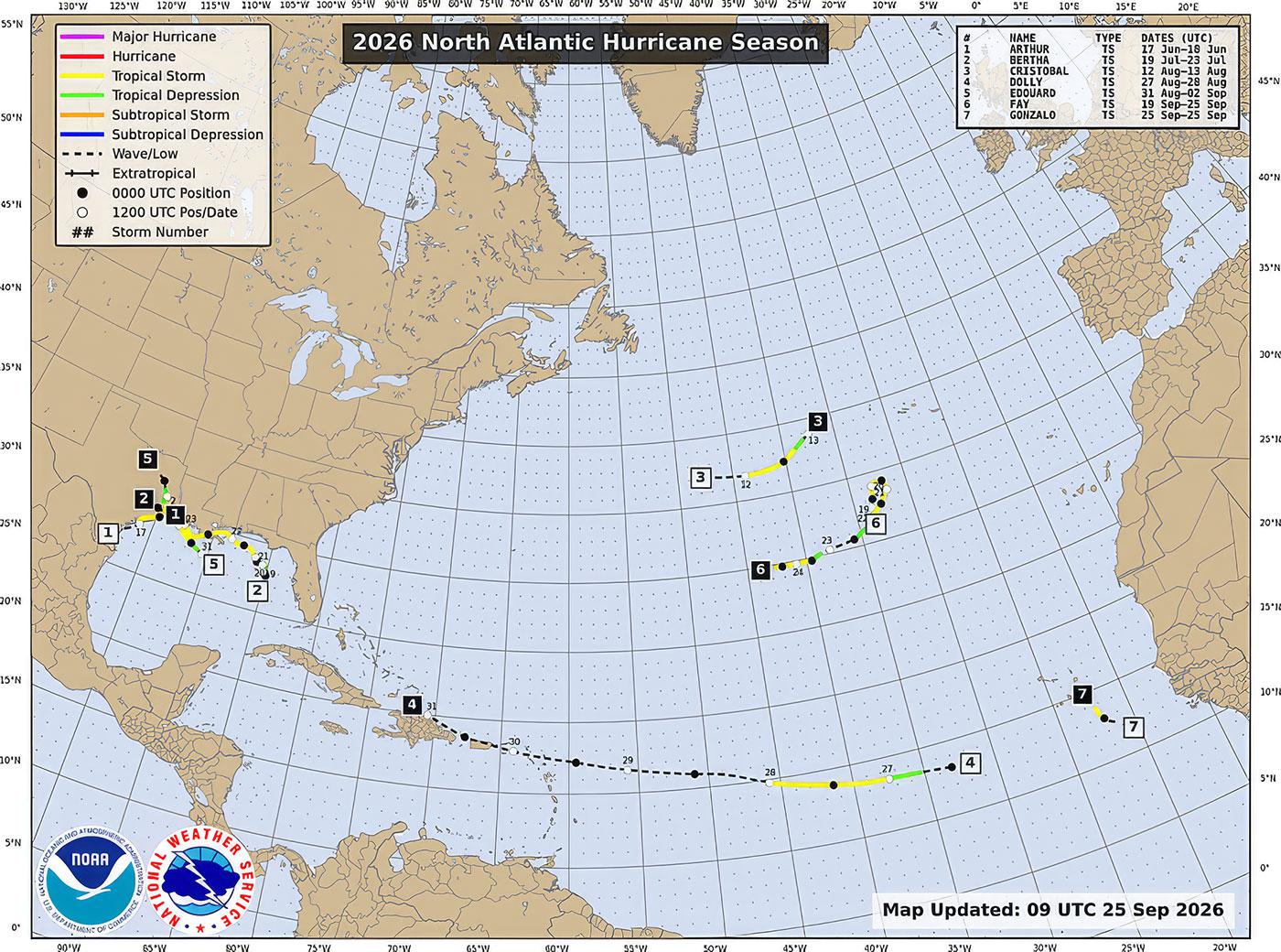
There hasn’t been a single hurricane.
The Atlantic hurricane season officially began on June 1, and September normally falls near the heart of its busiest period. Tropical storms have formed this year, but as of September 25, none has managed to strengthen into a hurricane.
Meanwhile, the eastern Pacific has been considerably more active, recently producing powerful hurricanes including Polo off the coast of Mexico.
One reason for that striking difference between the two oceans should sound familiar to DCSki readers: El Niño.
In August, DCSki examined the rapidly developing El Niño and what it could mean for the 2026-2027 Mid-Atlantic ski season. Since then, El Niño has continued to strengthen, and its effects are beginning to show up in weather patterns far beyond the tropical Pacific.
The unusually uneventful Atlantic hurricane season provides one example.
El Niño begins with unusually warm water across the equatorial Pacific, but its influence doesn’t stay there. The warming changes tropical thunderstorms and atmospheric circulation, setting off effects that can extend thousands of miles from the Pacific.
For Atlantic hurricanes, one of the most important effects is increased vertical wind shear. Tropical systems need a relatively calm atmosphere above them to organize and strengthen. When winds change substantially with altitude, developing storms can become tilted or disrupted before they have an opportunity to intensify.
NOAA’s Atlantic Oceanographic and Meteorological Laboratory explained before the hurricane season that the developing El Niño was expected to increase wind shear across the Atlantic and suppress hurricane formation. In June, NOAA placed the probability of a below-average 2026 Atlantic hurricane season at 55 percent.
So far, the Atlantic has been even calmer than expected.
At the same time, NOAA’s latest measurements show that El Niño continues to strengthen. In its September 10 update, the Climate Prediction Center reported sea-surface temperature anomalies exceeding 3 degrees Celsius in parts of the eastern equatorial Pacific. Forecasters now place the probability of a very strong El Niño during the fall and winter above 90 percent.
An experimental forecast from NOAA’s Geophysical Fluid Dynamics Laboratory reached a similar conclusion in September. Although its latest forecast backed off slightly from the extraordinary peak projected a month earlier, all 30 members of its forecast ensemble still indicate that the developing El Niño will compete with some of the strongest events in the historical record.
What Does This Mean for Skiers?
The lack of Atlantic hurricanes doesn’t tell us how much snow will fall at Timberline, Whitetail, Seven Springs, Snowshoe, or any other Mid-Atlantic ski area this winter.
But it does provide another indication that the changes taking place in the tropical Pacific are having a substantial effect on the atmosphere.
That is worth watching because some of the same large-scale changes will help shape North American weather as we move into winter.
El Niño commonly strengthens the subtropical jet stream, increasing the flow of Pacific moisture across the southern United States and toward the East Coast. NOAA’s latest seasonal outlook continues to expect the characteristic El Niño precipitation pattern to become established as the season progresses.
For Mid-Atlantic skiers, moisture is only half of the equation.
As DCSki’s August El Niño outlook explained, the region can have an active storm track and still experience a poor ski season if cold air isn’t available when storms arrive. The same moisture-rich pattern can produce a major snowstorm, a messy mixture of snow and ice, or a soaking rainstorm depending on temperatures and the path of each storm.
Past El Niño winters illustrate the range of possibilities.
The powerful 1997-1998 El Niño contributed to a disastrous Mid-Atlantic ski season dominated by warmth and rain. The 2009-2010 winter paired a more moderate El Niño with persistent North Atlantic blocking and produced extraordinary snowfall around Washington and Baltimore. The very strong 2015-2016 event began with record warmth in December but later delivered a blockbuster January snowstorm.
NOAA’s September outlook still favors above-normal temperatures across much of the eastern United States during the October-through-December period. That isn’t particularly encouraging for early-season snowmaking, although a three-month temperature outlook cannot tell us whether resorts will receive several productive cold stretches within that period.
There are still several months before the heart of the Mid-Atlantic ski season, and atmospheric patterns that cannot be predicted reliably this far in advance will have a large say in how the winter unfolds. The availability of Canadian cold air, the position of the jet stream, and the behavior of the North Atlantic Oscillation will help determine whether approaching storms bring snow or rain.
For now, the Atlantic hurricane season offers an interesting preview of El Niño’s reach. The next question is what El Niño will do when winter arrives.



Reader Comments