
When DCSki last examined El Niño in July, the event was still developing and its eventual strength remained uncertain. A month later, the forecast has become considerably more striking.
In simple terms, El Niño develops when an enormous stretch of the tropical Pacific Ocean becomes unusually warm and stays that way for months. The extra heat changes where thunderstorms form over the Pacific, and those changes can alter the jet streams that steer weather systems across North America. El Niño does not dictate the weather on any particular day, but it can tilt the odds toward certain patterns over the course of a season.
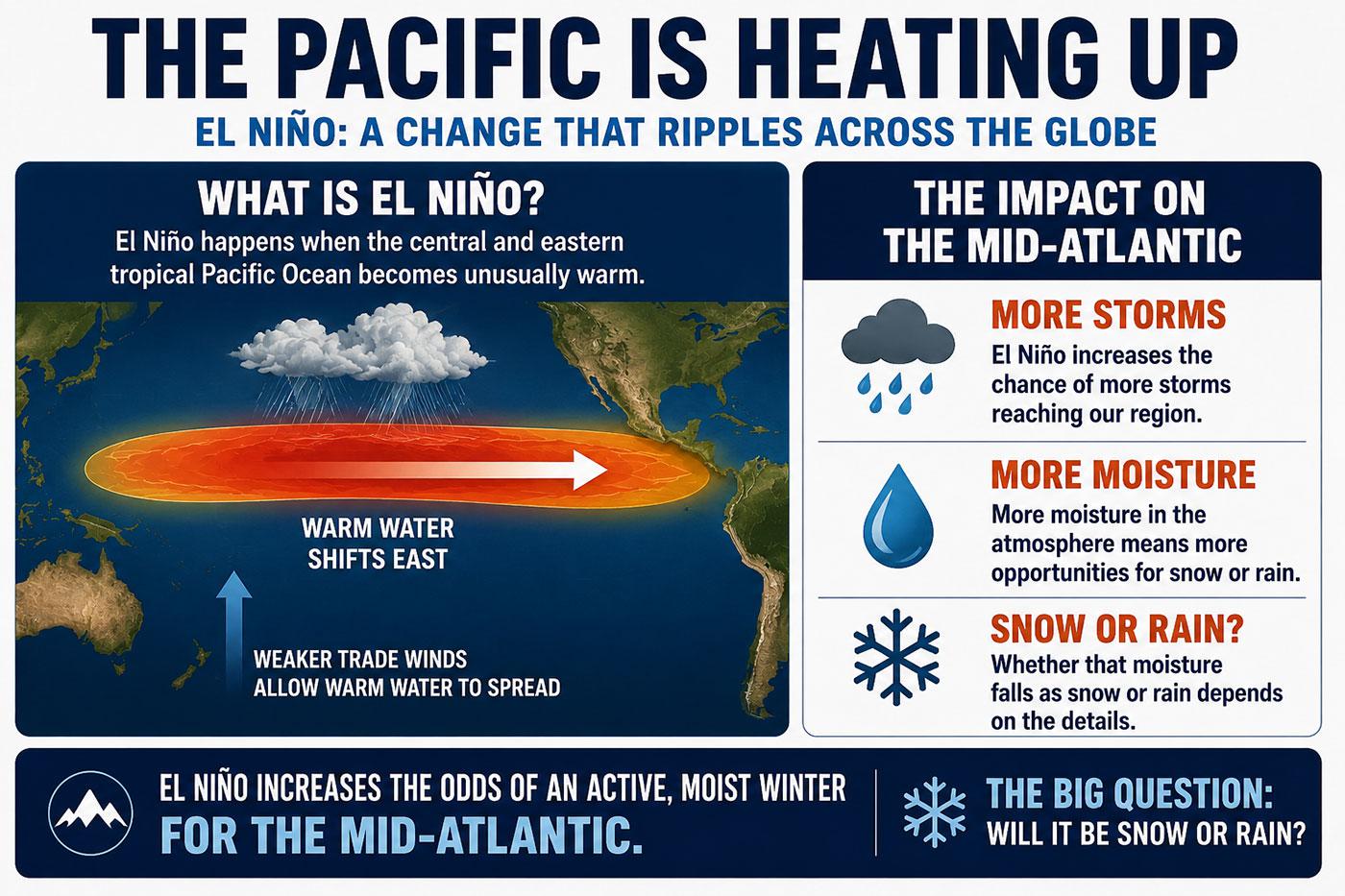
For the Mid-Atlantic, that often means a more active storm track carrying moisture across the southern United States and toward the East Coast. Whether that moisture falls as snow or rain depends on whether cold air is in place when each storm arrives.
El Niño is now firmly established in the tropical Pacific and strengthening rapidly. In its August 13, 2026 diagnostic discussion, NOAA’s Climate Prediction Center placed the probability of a very strong event during the fall and winter above 90 percent. NOAA also assigned a 69-percent chance that it will reach a level exceeding any previous El Niño in its record dating to 1950, based on a newer measure that adjusts for the warming background climate.
An August analysis from Columbia University’s International Research Institute for Climate and Society found similarly strong agreement among forecast models. Twenty-five of 26 models placed El Niño in the “very strong” category during the October-through-December period.
For Mid-Atlantic skiers and ski area operators, those forecasts are impossible to ignore, although they still fall well short of telling us how much snow will fall at Whitetail, Timberline, Snowshoe, Seven Springs, Massanutten, or anywhere else in the region.
But the past could be prologue. El Niño has been associated with some of the snowiest winters in Mid-Atlantic history. It was also blamed for the disastrous 1997-1998 season, when warmth and rain repeatedly forced local ski areas to close. Both possibilities remain in play for the coming winter.
A powerful change in the tropical Pacific
The scientific name for the larger ocean-atmosphere cycle is the El Niño-Southern Oscillation, usually shortened to ENSO. El Niño is its warm phase, La Niña is its cool phase, and periods between them are described as neutral.
Under typical conditions, steady trade winds blow from east to west across the equatorial Pacific, pushing warm surface water toward Indonesia and allowing colder water to rise near the coast of South America. During El Niño, those winds weaken. Warm water spreads eastward, tropical thunderstorms follow it, and the circulation of the atmosphere begins to shift.
Across North America, El Niño often strengthens the subtropical jet stream, carrying Pacific moisture across the southern United States. The southern tier tends to become wetter, while the northern tier often trends milder.
The Mid-Atlantic sits near the boundary between those broad patterns. It can receive moisture from the active southern storm track, but snow still requires cold air from Canada to be present when each storm arrives.
This year’s Pacific warming has developed quickly. By July, sea-surface temperatures in the central and eastern equatorial Pacific had risen sharply above average, while a large reservoir of even warmer water remained below the surface. Changes in winds, atmospheric pressure, and tropical rainfall indicate that the atmosphere is responding to the warming ocean.
NOAA’s reference to a potentially historic event is based on the Relative Oceanic Niño Index, or RONI. Unlike the traditional Oceanic Niño Index, RONI compares Pacific warming with temperatures across the broader tropics. This helps account for the fact that oceans around the world are warmer than they were during El Niño events many decades ago.
NOAA currently sees a 69-percent chance that the three-month RONI value will reach at least 2.5 degrees Celsius above its baseline late this year. That would represent an exceptional disturbance in the tropical Pacific. It would also strengthen the odds of familiar El Niño weather patterns appearing across the United States, although individual storms will still be shaped by many other atmospheric forces.
NOAA’s early winter outlook
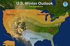
NOAA released its latest long-range seasonal outlook on August 20. Forecasters expect the El Niño precipitation pattern to become increasingly pronounced as winter progresses, with above-normal precipitation favored across much of the southern United States and Southeast.
By the core winter months, the wetter-than-normal signal extends northward along almost the entire East Coast. That suggests the Mid-Atlantic could see an active storm track and frequent opportunities for precipitation.
Temperature is the complicating factor. NOAA favors above-normal temperatures across the northern tier of the country during the December-through-February period, with the warm signal extending into the Northeast. Across the Southeast, El Niño’s tendency to produce cooler weather competes with the recent warming trend, leaving a less decisive forecast.
Pennsylvania lies closer to the warmer northern signal, while Virginia and North Carolina are nearer the transition zone. West Virginia’s higher ski areas add elevation to the equation. Snowshoe reaches 4,848 feet above sea level and Timberline tops out at 4,268 feet, placing both resorts in a much colder setting than ski areas closer to Washington and Baltimore.
The combination of a wet East Coast and a potentially mild Northeast captures the uncertainty facing local resorts. There may be plenty of storms. The success of the ski season will depend on what side of the rain-snow line the mountains occupy when those storms pass through.
A difference of a few degrees
Seasonal precipitation forecasts do not distinguish between rain, sleet, freezing rain, and snow. For a ski area, those differences can define the entire winter.
A moisture-rich coastal storm arriving with temperatures in the 20s can transform a ski season. A similar storm arriving with temperatures in the mid-30s can erode a carefully constructed base, close lifts, and force snowmaking crews to rebuild.
The path of each storm will be critical. A low-pressure system tracking inland and west of the Appalachians generally draws warmer air northward through the region. A storm moving along the Gulf Coast and then offshore near the Carolinas has a better chance of spreading moisture over cold air already in place. Small changes in the track can move the rain-snow line by hundreds of miles.
The importance of the North Atlantic
One of the most important influences will be the North Atlantic Oscillation, commonly known as the NAO. Its phase helps shape the flow of weather systems across eastern North America and the Atlantic.
A negative NAO can encourage blocking at high latitudes, slow storms, and help cold air remain in the eastern United States. A strongly positive NAO often supports a faster and milder pattern, allowing storms to track north or cold air to retreat before moisture arrives.
The National Weather Service office serving Baltimore and Washington studied local snowfall since 1950 and found a strong relationship with the NAO. The historic winter of 2009-2010 combined a moderately strong El Niño with a deeply negative NAO, producing 56.1 inches of snow in Washington.
Unfortunately, the NAO fluctuates over much shorter periods than ENSO and cannot be forecast reliably for an entire season. By late fall, forecasters should have a very good understanding of El Niño’s strength. They still will not know whether North Atlantic blocking will appear during a particular January storm.
Past El Niño winters offer conflicting clues
The National Weather Service reviewed 23 El Niño winters since 1950 for Washington and Baltimore. As a group, those winters averaged near-normal temperatures and precipitation, with above-normal snowfall. Moderate El Niño events produced the highest average snowfall.
Strong events produced much wider swings. Of seven strong El Niño winters in the agency’s analysis, four delivered well-above-normal snowfall to Washington and Baltimore. The other three produced almost none.
DCSki’s reports from several of those winters show how differently an El Niño season can unfold.
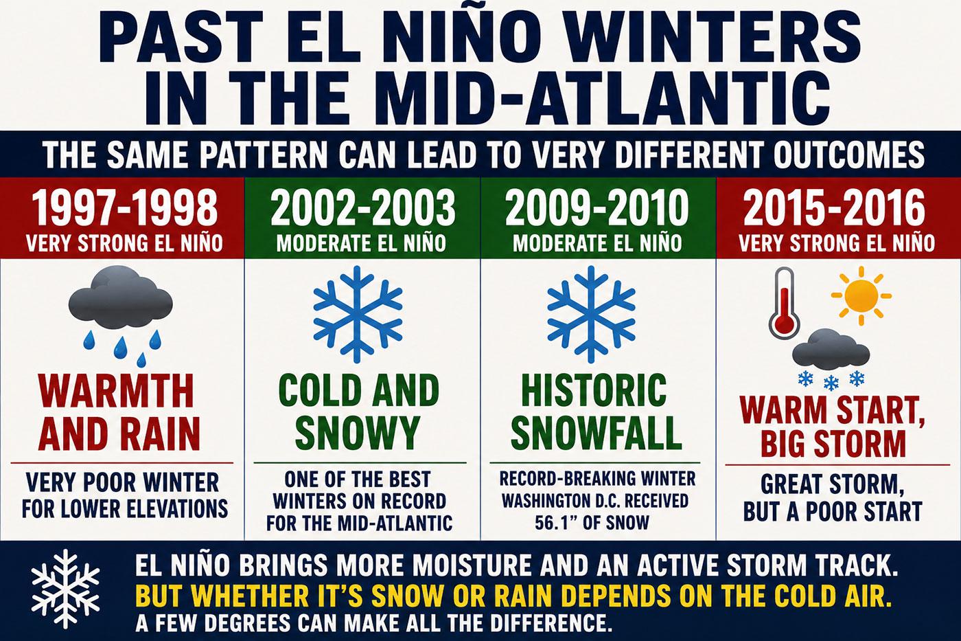
1997-1998: warmth and rain
The 1997-1998 El Niño is the comparison Mid-Atlantic ski operators would most like to avoid. It was exceptionally strong, with its largest temperature anomalies concentrated in the eastern tropical Pacific — characteristics shared with the current event.
Warmth repeatedly interrupted snowmaking that winter. Liberty, Roundtop, and Whitetail opened with limited terrain in mid-December, then encountered temperatures in the 50s during early January. Resorts closed and reopened as cold fronts briefly returned, but rain repeatedly stripped away their progress.
As described in DCSki’s recent retrospective, When Winter Failed to Arrive, neither Liberty nor Whitetail opened all of its terrain. Both suspended operations on March 1.
Snowshoe experienced a different winter. The high-elevation West Virginia resort approached 200 inches of natural snow and continued skiing into April, demonstrating how several versions of winter can exist within the Mid-Atlantic at the same time.
2002-2003 and 2009-2010: when cold air arrived
In July 2002, DCSki reported that El Niño had returned. The memory of 1997-1998 was still fresh, and some readers responding to the story expected another disappointing winter.
But the 2002-2003 season became one of the region’s best. Cold arrived early, resorts built deep bases, and natural snow repeatedly refreshed the slopes. The Presidents’ Day storm buried much of the Mid-Atlantic, capping a season DCSki described as one for the history books.
The moderate El Niño winter of 2009-2010 provided an even stronger example of the upside. A major December storm established snow cover across the region, and February brought a succession of enormous storms that shattered snowfall records around Washington and Baltimore.
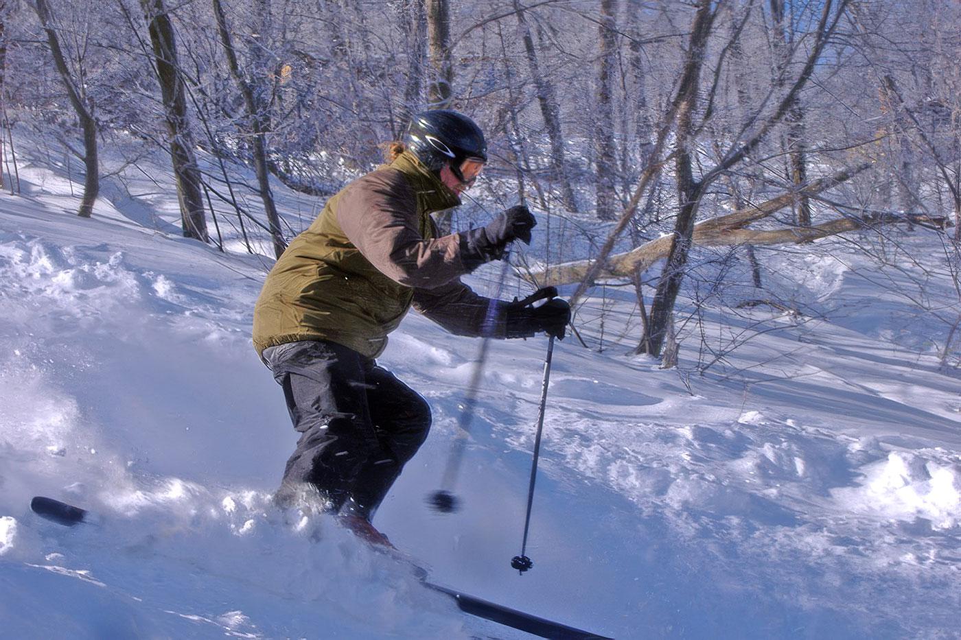
After the first February storm, DCSki Columnist Jim Kenney reached Blue Knob and found deep snow on the trails and in glades that often remain closed. In his Snowpocalypse Now Firsthand Report, he described the outing as one of his best local ski days in 43 seasons.
El Niño supplied moisture and an active storm track that winter, while a strongly negative NAO helped retain cold air in the East. It was an unusually productive combination for Mid-Atlantic snow.
2015-2016: a lost December and a giant storm
The very strong 2015-2016 El Niño followed a different course. December was extraordinarily warm. On December 23, DCSki published photos of snow from other places because there was so little to show locally. Christmas Eve temperatures approached the mid-70s, many resorts had barely opened, and some brought back golf and other warm-weather activities for holiday visitors.
Cold arrived in January, followed by a blockbuster blizzard that deposited roughly two to three feet of snow across parts of the region. The storm produced excellent skiing, but it could not replace the operating days and holiday revenue lost during December.
That season also shows why snowfall totals provide an incomplete measure of a ski winter. Resorts benefit most from cold stretches that arrive early enough to build a base and continue through busy weekends. One enormous storm surrounded by warmth can produce impressive statistics without producing an equally successful season.
Different implications across the region
DCSki covers resorts across Pennsylvania, Maryland, West Virginia, Virginia, and North Carolina. Differences in elevation, latitude, exposure, and distance from the Atlantic will help determine how each area responds to the coming pattern.
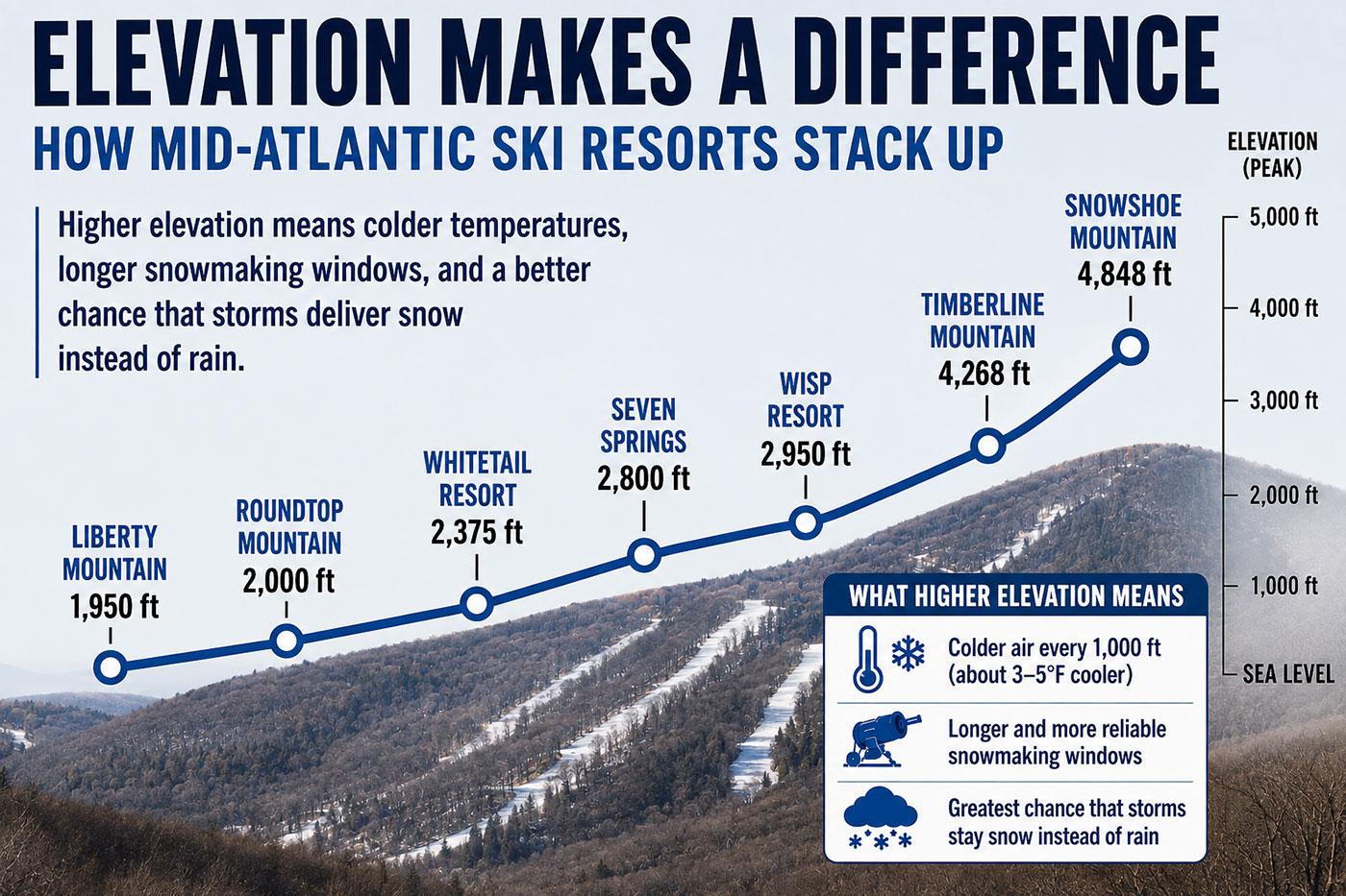
Snowshoe and Timberline may be best positioned to turn an active storm track into snow. Their high elevations provide colder temperatures and longer snowmaking windows, while northwesterly flow can generate additional upslope snow after larger storms depart. Strong southerly winds can still drive warm air over the highest ridges, as the 1997-1998 season demonstrated.
Western Pennsylvania and western Maryland occupy an intermediate position. Seven Springs, Laurel Mountain, Hidden Valley, Blue Knob, and Wisp benefit from elevation and a more favorable western location than areas near the Interstate 95 corridor. A strong El Niño can sometimes reduce the persistent Great Lakes and upslope snow showers that favor these mountains, however, placing greater emphasis on organized storms.
Lower-elevation resorts in south-central Pennsylvania rely much more heavily on snowmaking. Liberty, Roundtop, and Whitetail can quickly lose productive hours when warm Atlantic air pushes inland. During marginal storms, their proximity to Washington and Baltimore places them closer to the dividing line between snow, ice, and rain.
Virginia and North Carolina lie closer to El Niño’s favored southern storm track. High-elevation North Carolina resorts can receive significant snow when moisture encounters cold air banked against the Appalachians. An inland storm path can instead send warmth northward, producing rain or ice.
A single storm might bring snow to Timberline, sleet to Whitetail, rain to Liberty, and heavy snow to Sugar Mountain. A modest change in its path could rearrange those outcomes.
Snowmaking may be the more important forecast
Natural snowfall receives most of the attention, but the frequency and duration of snowmaking windows may have a greater effect on the ski season.
A winter that averages above normal can still contain several valuable cold stretches. If they arrive in early December, resorts can build deep bases before the holidays and protect themselves against later thaws. If the cold is divided into brief overnight windows, lower-elevation areas may struggle to open terrain or recover after rain.
An active storm track can also bring high humidity, raising the wet-bulb temperature and reducing snowgun output even when the ordinary temperature falls below freezing. Strong winds can carry machine-made snow away from trails, while freezing rain and heavy wet snow can affect lifts, trees, and electrical service.
Additional precipitation could help replenish snowmaking ponds after the region’s recent drought. Its value will depend on timing. Rain during autumn could improve water supplies, while a soaking storm in January could consume a ski area’s base faster than its reservoir can be put to use.
Modern snowmaking systems and automation allow resorts to capture shorter cold windows than they could in 1997. They still require cold and reasonably dry air, preferably for long enough to produce snow that will survive the next warm spell.
The forecast will continue to evolve
NOAA expects El Niño’s precipitation effects to develop gradually and become strongest during the heart of winter. The closest analogs suggest that the wet southern pattern may be delayed, leaving November and early December more dependent on shorter-term weather systems.
That makes the opening weeks especially difficult to predict. A cold start could allow resorts to establish strong bases before the storm track becomes more active. A warm December could resemble the beginning of 2015-2016, with the season finding its footing later.
Forecasters will continue monitoring the strength and location of Pacific warming through the fall. By November, the position of Canadian cold air, early behavior of the polar jet stream, and signs of North Atlantic blocking will begin adding detail to the broad El Niño outline.
Even then, the fate of an individual storm will remain uncertain until it is much closer. Seasonal forecasts can identify increased odds of a wet or mild winter; they cannot position the rain-snow line over a particular mountain months in advance.
An active winter, but what kind?
The latest evidence provides strong reason to expect a powerful El Niño influence and an active winter storm track. NOAA’s forecast of above-normal precipitation along much of the East Coast offers real potential for Mid-Atlantic snow.
The strength of the event also raises concern. Strong El Niño winters have generally been warmer and wetter around Washington and Baltimore than weaker events, and several produced almost no snow. The 1997-1998 analog is difficult to overlook, particularly for lower-elevation resorts.
The season could produce large swings, mixed precipitation, rain events, and one or more significant snowstorms. Higher elevations may experience a substantially different winter from resorts closer to Washington, Baltimore, and Philadelphia. A slow December would not rule out a snowy February, just as a single major storm would not guarantee a successful season.
El Niño is likely to send moisture toward the East Coast this winter. For Mid-Atlantic skiers, the decisive question remains where the rain-snow line will set up when that moisture arrives. DCSki will continue to track this weather story as the season approaches.




Reader Comments