The one and only time I skied there was 1976 after a 4 or 5 course meal at the Inn.It was very small and actually within an hour or 2 had to go to Camelback for some "real" skiing.They had an indoor iceskating rink also.
The monstrosity of an inn dates back over a hundred years and my parents honeymooned there in 1951.It is now a empty "haunted" mansion.
I learned to ski at Buck Hill in the late 70s. We were fitted with Skis that reached to my hand held over my head and lace-up ski boots. We went up the rope tow. A lovely lunch buffett was set-up and we stayed at the lovely old inn. I am very sad to hear that the Inn is to be torn down. It is a classic case of poor management and actual theft of many of its tresures - The stone work is lovely and can't be replaced in this modern day world. We ate lunch in the blue stone room, learned to putt on the putting green and spent hours exploring the arched stone walkways surrounding the Inn.
My name is G. Joseph Rogers and I attended Wilkes College (Now University) from 1961 - 1965. I was one of the founding members of the Wilkes Ski Club. The college had the 1963 Winter Carnival at Buck Hill Falls. As I recall every member of the Ski Club attended and skied. It was a fun day.
January 9, 2008
Smugglers' Notch Vermont
I stayed at the Inn back in 1970, while attending a convention during High School. We had the afternoon off and went over to the ski area. Some of the kids skiied, but I rented a sled so they must have had a sledding area. It was some of the best sledding I had ever done. We also walked over to the falls. I still have pictures of the frozen falls. I was sadden to see the condition of the inn a few years back. It was a grand and elegant place.
I went every winter for 10 years spanning 1960's to 1970's. learned to ski there. The J lift was difficult to get used to. There was no spring in the shaft and you were yanked up to speed. The Inn is a place I will never forget and wish it was still open. Ice skating and sledding were also next to the slopes. The slopes were not meant for speed, just fun.
My sister and I learned to ski here between 1966 and 1968 (3 winters). I also learned how to golf here. Our father was the comptroller at the Buck Hill Inn during this period (Huck Myrwang). We have many wonderful memories of our time there, including camp club in the summers, as well as the pool, and learning how to ice skate in the parking lot of the country club in the winters. Just returned from a visit to the area, my first in over 25 yrs. We moved away in 69. So sad to see the condition of the Inn itself. What a beautiful grand hotel it was in it's day!
I learned to ski at Buck Hill in approximately 1973 with an instructor whose nickname was Boobin. I remember pop music emanating from speakers at the base of the hill, and the hot chocolate in the ski lodge afterwards. My family rented a snowmobile at the ski lodge during Christmas in 1978, and we rode around hole 2 of the red golf course. The Inn was a great destination, and I wish it were open today. I don't care what MTV says.
We spent many happy family vacations at the Inn in the 1950s and 1960s. I hope it will not be torn down -- it was a wonderful place.
I grew up in Buck Hill and lived there just until last year. My father went skiing there in the 1960s and 1970s while staying at the Inn prior to buying our cottage. I grew up sledding and playing golf on what remains of the ski hill.
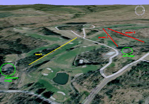
It is my understanding that they are planning on turning the oldest part of the Inn into condos and demolishing only the surrounding buildings, which they have been in the process of doing for a few years. A few of the current residents have purchased a stake in the Inn and have been working on revitalizing it for quite some time. Hopefully, with the addition of the winter activities area at the site of the old ski lodge the community will decide to eventually bring back the ski hill, especially since neighboring Skytop has recently improved their small ski hill.
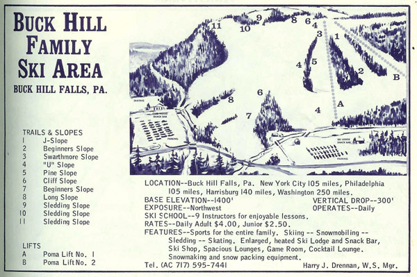
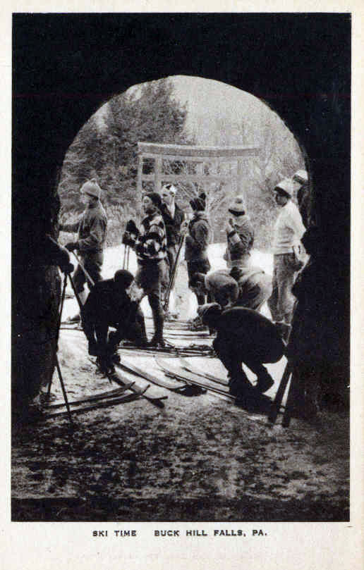
I was going to tell you of the trail map and of the postcard on my website, but Kevin beat me to it.
In reading through the comments on Buck Hill, I am amazed that folks are keying on the death defying Poma Lifts. As a young boy in the late sixties, I remember them as a holly terror. Typically, everything went relatively smoothly up to tower three or so. There the grip holding the Pama to the haul rope would slip momentarily and then reengage launching any child at least four feet into the air. If you were able to survive, it was smooth sailing to the top; otherwise clear the track. The likelihood of success was around 60%.
My family and I stayed at Buck Hill over New Years during the late 60's and into the 70's over New Years. I learned to ski at he Buck Hill Ski Area. Skating, hot chocolate and sledding were also available.
The hotel was grand and impressive. Now the surrounding area is great but the hotel looks like it is ready to fall down (like the staff building in front of the dining room).
Many wonderful memories.
I was born and raised at Buck Hill basically. Grew up there with my mom and dad both working at the inn. I learned how to ski on the Buck Hill slopes. Loved the poma although remembering no to sit down on it was a challenge but before I knew it I would bolt out of the starting gate by holding the poma back until the spring was totally stretched and then jumping in the air and going airborne. Probably one of the people that helped knock others off.....sorry...hahaha. All this was back in the 60's and 70's time. What a beautiful place it was back then.
My dad, Jim Shakespeare, was the tennis pro at Buck hill from 1965-1975. Spent wonderful summers there, and lived in Cottage 53, which is now the Buck Hill post office. Passed through a couple of summers ago and was amazed that such a grand place had just fallen apart and was covered with tall weeds. Saw a little family of deer wandering through what used to be the stables. Many of my best childhood memories are of that place!
Some of my best learning to ski memories are from Buck Hill. My Grandparents went to Buck Hill in the early 20's, buying a cottage in the 30's I learning to ski Buck Hill as soon as I could walk, late 60's through the early 70's with the wooden skis and lace up boots. I wish I could remember the instructors name, he wore Hawaiian shirts, was hard of hearing and yodeled as he would spin his way down the slopes. He would tuck me between his legs on the poma lift and away we went up the hill. Then he would ski backwards holding the tips of my skis as he steered me left and right down the hill.
Summers were great, when I was younger I went to camp club when I was older I worked in the barn, great times! At night we would play pool in the game room and had the best times with friends. The High dive is no more, and the wooden raft in the pool is a new solid fixture covered with an all weather carpet.
It is truly sad to see such a grand hotel stand dormant. When you glance inside it is like everyone just walked away in the middle of the day. The tables were set for a meal and everyone vanished.
The Cottagers have kept the tennis, golf and camp club alive and the falls will alway be there, now without having a booth where you would pay to see the falls. The water at Red Rock is still refreshing as ever.
It was great to read all the comments thank you!
Okay a revision on the condition of the Inn. When I said it looked like everyone just walked away, well that was 7 years ago. I revisited the Inn today and it is in bad shape, it now looks abandoned, it is so sad, it brought tears to my eyes.
I hope a deal can be put together to restore the old part of the inn!
I heard some investors from Kentucky are looking at the old Inn they where their from what I was told in
late Sept. and are coming back in April with blueprints and plains to show to the community. This came from the real estate broker, I really hope this is true would love to see the old Inn back.
Buck Hill Fall's Ski Area hold a very special place near and dear to my heart.
Johhny "Fuzzy" Martin was my Grandfather and "Boobin" was his sidekick, sort of speak.
I remember the likes of "Harry Drennon" the General Manager, "Slip" one of the nicest guys, he was the go to man when something needed fixing, when the snow needed to made or when the poma needed fixing. And was it Hilda who was behind the concession stand serving up the hott chocolate and french fries. Every one has long sinced passed, but I think of those days and those special people and how they played a significant part in my childhood and later.
I was lucky enough to live that life every winter from age 4 until my first year of college. Scott "Flash" I think I know you actually! lol
It's unfortunate to see the inn in ruins. Yet, the area is still very, very beautiful! And the Pocono's is in my blood!!
Love, Sandy
I am working on a google map of all the abandoned ski areas in PA. After reading these articles I wanted to make a map of these abandoned ski resorts and share them with you. Some ski resorts you will see are not even visble on google earth anymore. To skow all of you where they are Wanted to share this map. Everytime I add a new part of the map I will share the link.
https://www.google.com/maps/d/u/0/viewer?mid=1zBCb6LCm5KG-mi-BRMzzXFb_Wvzj-fzR&ll=40.09695855922546%2C-76.98060575366367&z=14
That is the link. Enjoy and tell me if there are any problems.




Reader Comments