Weather thread: 12/3-12/10
December 10, 2008
54 posts
12 users
25k+ views
Making an attempt to create a single place were we can all discuss forecasts and such.
Here is the basic idea (this was a response to andy's comment but it should give the general idea:
________
Make a thread every week on wednesday as well to discuss possible altercations in the forecast. Then every week we can start a new thread so as to minimize the length of the individual threads and make it easier to follow for everyone? Would also be a great place to post snow totals and such. That way this detailed weekly forecast is available and if people choose, they can dive into further detail/critiquing in the forum thread. I figured that by wednesday we will have a good gasp on the weather for the weekend (which is what people care about the most) but as you and I know, everything can change and it is fun to discuss other possible events that pop up.
_______________
Discuss!!! some fun weather in store, definitely should be an active thread through the weekend and early next week!
Here's what I am seeing for Snowshoe among several models. Snow amounts accumulated by Monday are:
NAM: 3-5"
ETA: 0-2"
Meso-ETA: 1-3"
GFS: 3-5"
This is down to the county level, and doesn't necessarily represent us the on-mountain totals (but it's usually close for a nominal number). I will update this later tonight if it changes significantly. Consider these guesses that we can play Monday morning quarterback with.
I am still waiting for my Wx weather app to roll into the 36 hour range where it pulls snowfall from the NWS NDFD grid forecast (which uses several of the models above along with reckoning of the local NWS office). Right now it's showing a total of 0.18" liquid precipitation for Snowshoe from Saturday 7pm through Sunday 1pm. I'll post up a full forecast for Snowshoe once the data rolls in.
It will keep going into sun eve..i'm betting on the 2 to 4 thing. Not as exciting as when i posted the powder watch thread....the interesting storm is the one to come up next week..coin toss for now as to which side of the Alpps it will track. The back side of the clipper will bring very cold skiing for sun/mon...good news for David..he loves it Cold...
You get some sort of paid weather pro svc 219? Wx weather app? I'm too tight to go for any..too much free stuff although a little harder to work with maybe.
Been watching Siberia for awhile now, among various other strategic sites around the world to help me guage the cold being generated at our cold factory spots. Siberia has been running above ave for oct & into early nov but is chillin down big time now...been running around 55 below for a week now & has just got down to the 62-66 below range in the last 24 hr's or so....that is COLD. Maybe the East coast was robbing all of their cold energy but they have overcome

....
skier219 I am assuming you re referring to the experimental kinkd to on the NWS page?
click if you want to zoom into a specific area I am going to stick with my 2-5 for sat-sunday, I think that is just about right for wisp, 7 springs, canaan areas, and shoe (may get the least out of all).
Looks like i was about right with my 1-4 for yesterday-today, little bit on the low side but still within the range.
Models still not giving us any consistent forecast for early next week, going to be really cold sun-mon but whatever happens on tues-wed is still up in the air. I will try to post a synopsis on this event later today and update that daily until we get a beter idea on what is to come. Skiing next weekend should be great regardless, most likely rain to snow for everyone with very cold temps (even colder than today) for the latter part of the week. Great snowmaking. I am going to stay with my estimate for many resorts to be at 100% operation by christmas unless we get a massive thaw.
"whatever happens on tues-wed is still up in the air"
Literally!
This is my app:
http://hunter.pairsite.com/wx/ , not "pro" by any means, but more of a detailed consumer/business/hobbyist tool. It started life as a ski-reports app, then I added snowmaking computations, then I made the ski stuff a subset of a larger weather app (ski report and snowmaking calcs are now optional, along with many other plug-ins). The key feature has been the ability to tap into the NWS forecast database with a lat/lon coordinate. They have a nominal 5km spatial grid, which is finer in mountainous areas and along coastlines, so it's possible to get a pretty good forecast in those areas. They provide temporal data every 3 hours for the first 24 hours, then every 6 hours out to 168 hours.
I finished up a SNOTEL reporting plug-in last year that a couple guys out west have been testing -- it reads snow levels from automated measuring stations all across the mountains. I hope to have that released soon.
cool product!
Just wondering, so you do use that forecast that NWS produces that i linked too above correct?
btw.. perfect snowmaking tonight, lows in lower teens to upper teens tonight at resorts. Should be able to build a great base with this weekend's weather.
I like to stay Stupidly positive but I think I might of Jinxed our east Coast run with the posting of things Chillin in Siberia...1st of & please confirm anyone, Things are looking like we will be on the warm side of a complex system next week that is way above my amature pay grade (Zilcho)..the alpps always get into a little snow action sooner or later...tail end of this tail of that..scraped by another system later on in the week...& then the Dreaded ridge in the SE??!?....
I would not look too far past the first system, extreme amount of disagreement after midweek (should get cold but how cold???). I do think most will start as rain or a mix but change to all snow before the end, big question is how fast that change might take place. Also, i do not see any real signs of any extended thaw for the next two weeks or so.
cool product!
Just wondering, so you do use that forecast that NWS produces that i linked too above correct?
I haven't made a detailed comparison with their web product (it's fairly new), but I assume it's based on the same data I pull from the NDFD XML feed.
Here's the detailed forecast for Snowshoe -- the latest model run gives snow totals for Sat-Sun, and it predicts about 4" with a snow:water ratio of about 17.
http://hunter.pairsite.com/craig/wx-pro-snowshoe.pdfSorry for the PDF, but it's the easiest way to export from the app right now.
Other than general info, I wouldn't trust the forecast beyond about day 4; in fact, it will likely change for days 1,2,3 over the next few hours. If I have any beef about the NWS data feeds, it's that they dink around up until the last minute, and don't seem to settle in as smoothly as I'd like. Perhaps that is the nature of forecasting.
skier219,
Thanks for sharing the weather site! Lotsssssss of data. One question, any idea where the measuring point is relative to Snowshoe topography...at the top, bottom or middle?
The colonel

It's about midway up the hill on the basin side -- I felt that was the best point to sample. But we're actually interpolating from the discrete grid covering that whole area, so it's not a true/exact forecast for that specific point and elevation. More like an interpolation from all the nearest data points to that point/elevation. The grid spacing is on the order of 0.5 to 1km in that area if I remember right.
Perhaps that is the nature of forecasting.
Completely is, one of my profs (John Nese, formal senior met at the weather channel) would like to tar and feather people trying to predict snowfall or even prcip for that matter more than 2 days out. Problem w/snowfall is that if you assume 15:1 ratios forecasting an inch of snow means that you need to be able to accurately forecast if a place is going to get .07 inches of rain which, if you think of it with rain you normally see forecasts for rain it is in increments of .5 or .25. Even those forecasts are extremely hard to forecast even 24 hrs out. On top of that, models are notoriously bad at forecasting precip let alone elevation or lake effect.
well that was the most useless 2 inches of snow ever.
skied seven springs, they had alta like quality with out the quanity. Give me dense snow or give me alot of it!!
Reading all the F-casts this morn, you would get the impression that all is well in the western front Alpps...a lot of Snow mention with a little Rain mixed in...I don't see it...Mon Morn Someone will be loving life From SS up thru to the SW PA areas..after that Looking for things to get wet & then the cold returning wed Aft/eve. Next weekend looks good with a warm up sun. You know..that really does sound good for early Dec in the Mid Atlantic!
It seems that Weather F-casters hold off till 24 hours, not the 2 days you all graciously gave them credit for before the event to make a accum call. They don't make F-casters like they used to...Sitting around waiting for the Models to tell them whats going on...Back in the old days they used to earn their money pouring over tons of info & then making their own decision... Old DC weatherman Gordan Barnes & the Dude before him come to mind..the Doug hills & the rest of them that followed are no better than the Ave Joe like me that just sit around & wait for the new Model to tell us whats up!...L-Ski might have an issue with that

actually, the guys i like are people like doug... they do make a real forecast which is not always the case today.. lots of news stations outsource their wx reports. A good met will definitely use models but the real skill is the interpretation of those models, reading a model word for word or even close to it is a horrible idea. I always try to check out he models for a quick picture and then make a forecast based on phat I know about atmospheric dynamics AND esp with mountain forecasts, mesoscale events like thunderstorms for summer or lake effect in the winter.
oh and btw, tonight's clipper should give a great 2-5 (sticking with my wednesday forecast) for canaan/timberline/shoe and laurel highlands areas (including wisp). Flurries and snow showers for everyone else! Have not looked at tues' storm recently.. might later, if I do I will post.
Its been many moons since I lived in the DC area so maybe Mr. Hill has got better...There was a time When The Palka's, Hills..NBC's Ryan & Topper (Is he still around?) Didn't even know where Canaan Valley was let alone the amount of Snow the Wv areas recieved. I bugged Topper enough to actually do a piece on Canaan Valley because he didn't believe that the valley got 150"'s a year...Doug Hill told me that if I loved the Place so much that I should buy a place there...I Did!...Topper was my Fav..Hill was a grouch...Sue Palka was a sweetheart & actually called me to find out what was going on up at the Alpps...Good ole days Harrasing the Local Weather folks in DC to mention Tucker Co,WV instead of the always mentioned Garrett Co,MD!
PS..I'll try to keep my future posts on this thread to anything to do with the time period involved & with the weather for Mid Atlantic Ski areas that we are interested in...signed..the mouth that moved south...
Wx NDFD is saying 6" for Snowshoe, whereas the models look more like 3-5". Be interesting to see the tally.
Cripes, next week just went to crap -- 42-46F at Snowshoe on Tuesday-Wednesday with rain! Last runs were calling for 35-37F. Still plenty of time for the models to iterate...
latest model runs are not fun to look at. lots of rain
fishnski,
I think the weather "dude" before Barnes was Woody Allen. I can still see him drawing on a paper pad showing fronts, etc. He would make a cartoon each night and called it a "woodle".
When a low would form over Oklahoma in the winter he would say "the ducks are on the pond". I really like Woody, he was a professional at a time most of the weather personalities were knock out women (usually blonde); however, I shoveled a lot of his flurries! Anybody remember Tippy Stringer on Channel 4?
The Colonel
latest model runs are not fun to look at. lots of rain
yeah but the snow totals went up for northern vermont. thats a plus side!!
You Da Man Colonol!..Woody Allen..Yes.
Surprise,Surprise..Or should we be surprised? Clipper Has tricked the Best once again with Snowshoe CKing in with 8 & Bayard,WV seeing 5 this morn so with the 2 Canaan areas sleeping in I'm guessing they got at least 6 inches..Sw Pa areas getting 2 to 3...But that was just the clipper part, now we have Switched to the LEU (Lake Enhanced Upslope) My new Pet name..The thinking is that the moisture will be running out before this aft so the LEU will be shortlived...well see!
Been talkin wet now for a couple of days & even hinted at the Dreaded SE ridge setting in for awhile...you finally seeing a little warmup L-Ski?..Don't think it will last that long because there is too much cold air up north & I just don't see the pattern doing a complete flipflop & staying that way...Stay tuned..
Canaan just cked in with 4.6..Hmmmm..SS must have gotten themselves into a nice snow band..
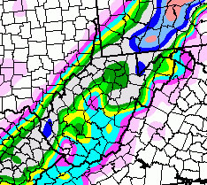
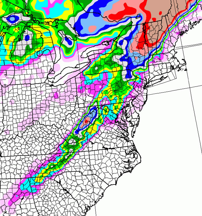
So this time around, the NAM-parallel run came closest by suggesting 4-6" for Snowshoe.
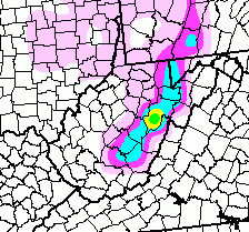
(green is 5")
The other models are still showing 2-4" at best. Based on what I saw from the NWS feed, they probably give more weight to NAM for snow numbers.
That warmup next week looks painful -- over 48 hrs of above (24 hrs well-above) freezing temperatures at Snowshoe.
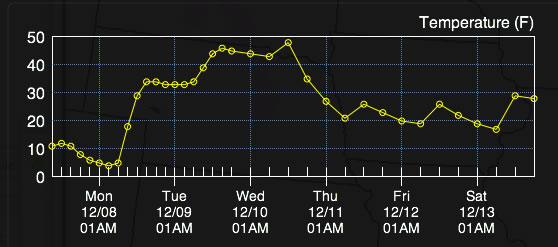
I hope the warmup moderates a bit. It's up to 49F Wednesday, with rain.
Middle of this week's rain is going to be a real basekiller. Most likely situation is now for a possible mix to rain with increasing temps to around or over 50 in most areas. Rain + 50's is a horrible situation, possible most of white grass will melt out besides the highest slopes and snowfarm area. Also, anywhere that does not already have 12+ inches of snowmaking is in danger. Even worse is that the cold following the warmth is not going to be nearly as strong as it was originally depicted.
Looks like cold today/tomorrow warming on tues/wed and then cooling back down for the weekend with temps slowly moderating to close to normal.. probably another system after that point but its anyone's guess what it will do. Looks like a east coast ridge will briefly build in but hopefully be pushed away.
If i was a resort manager, i would focus today and tomorrow on building base on open runs instead of concentrating on opening new runs (unless solid snowmaking has already occurred and the slope is close to open).
Well, it will be interesting to see what exactly happens this week at the WV areas. Here is Snowshoe weather for Wed/Thurs from Sunday AM slope conditions report: Wed. Hi: 29 | Lo: 24
Thurs
Hi: 27 | Lo: 15 .
Now that does not look too bad, but by now maybe it all has changed.
Anybody notice how the West has been a bit short on snow and cold, while here in the East we have had near records of both at the WV resorts. Now the forecast for Park City is showing lots of snow and cold for the next couple of weeks. Does this mean warmth for the East, or just near normal temps?
The Colonel
About 5" in the Valley last night. Got to the ski school desk this morning and the forecast called for 3-5" today. Not sure what happened, but it was nothing but blue skies and sunshine????????
zonal its not really a trough out there yet.
the wasatch(or the hell skis PC anyways?)is just catching the downslope of the trough on the east coast.
anyone else psched its going to dump in vermont now!
You counting on the low that will form off of the carolinas at the tail end of this next rain maker...& it will rain up at vermont too....to get close enough for Vermont?...I'm thinking maybe NH might get a little action.
Well, it will be interesting to see what exactly happens this week at the WV areas. Here is Snowshoe weather for Wed/Thurs from Sunday AM slope conditions report: Wed. Hi: 29 | Lo: 24
Thurs
Hi: 27 | Lo: 15 .
Now that does not look too bad, but by now maybe it all has changed.
Snowshoe is still showing those numbers, but I have no idea why -- they are dead wrong about Tues & Weds (Thurs is reasonable). Maybe they have their heads buried in the snow, too afraid to look at a weather update.
We're in for a roller coaster over the next couple weeks, and I will probably defer the Snowshoe trip I planned for next week. In retrospect, this past weekend was a good opportunity to take advantage of the great early season conditions, perhaps the last chance for a while.
We'll get the warmup with rain Tues-Wednesday, a brief Thurs-Fri cool down that will make the early weekend skiing icy, and then a warmup and moderation to milder temps Sunday-Thursday next week with some more rain mixed in. That rain may go over to snow/ice when temperature drops again Thursday. Past that point, I see another warmup.
Ohhh Noooooooooo!!!!!!!!!!!!!!!!!!
My fingers are still crossed for a continuing cold and snowy winter.
I would guess .5-1.5 inches of RAIN for everywhere from NC to Main (Vermont will be rain or possibly some freezing rain but most likely NOT snow) with temps in the mid 40's-mid 50's throughout the event. Temps should steadily drop on thurs back to around freezing. Skier, i think this weekend, despite the rain, should still be nice for early season skiing. With grooming and snowmaking I see no reason not to head out this weekend, should be great weather for skiing! Adding to this is that it looks like on sat we may get a coastal (instead of an inland) storm that would bring the first real snowstorm for the east coast (depending on the track). Sunday could be GREAT for skiing. Most places should be able to return to round the clock or at least nighttime snowmaking by thursday around midnight.
Looks like temps will slowly warm after that system with the overall pattern becoming much more zonal (less severe) with cool and warm periods but nothing really crazy like we have had for a month now. Dont want to speculate past a week, just good to note that the general pattern will moderate after this weekend.
Snowshoe is still showing those numbers, but I have no idea why -- they are dead wrong about Tues & Weds (Thurs is reasonable). Maybe they have their heads buried in the snow, too afraid to look at a weather update.
I believe Snowshoe uses a random weather forecast generator. And more often than not, it's warmer and less snowy than reality. At the very least you'd think they would make the effort to cut and paste the free pointwise NWS forecast.
Oh well... Having a glass-full personality, the silver lining is that the roads will get cleared up. It was pure hell coming back from Snowshoe yesterday, at least until after Judy Gap. The rain will clean up most of the accumulated ice and snow on the road and replenish the lake, which needs to be. After that, frightful snow is a blessing for the rest of the season.
Vermonts MT Mansfield hit a record low of -20 last nite breaking the old record of -13..
5 or 6 days ago I started seeing signs of that dreaded SE ridge & Voila!..here it comes..some might call it zonal but if there is a high sitting out over the water in the SE its a ridge to me....don't worry though because I'm going to FL for X-mas/new years & 13 out of the last 15 times I froze down there during the same period..Sorry Murphy, but thats the law..the cold will return!
Next week is shaping up to be miserable. Tomorrow's rain event looks to total around 2 inches (of rain!) for the mountains followed by some snow late in the week... but nowhere near enough to amke up for the base loss due to the rain. Now also looks like this friday's system is going to run more inland, which, depending on the exact trace my be good or bad for resorts. However, overall, looks like a possible snow/sleet to rain event for most followed by some backend snow. Still a possiblity for it to stay snow/ice for mountains (western PA and WV) but probably mixed to rain for local areas. Ill post more tomorrow.
Probably about the range of possibility. We ill not really be able to pin down this storm until it is happening! Hopefully before I post tomorrow, there will be a little more consistency with the mods
I just cked back at a post I made at 530pm on the 5th...I mentioned a scrape by a storm towards the end of this week. That tells me the models have been consistent about how close of a call this will be.The last GFS that I cked brought the storm a little further inland like L-ski said which would bring a motherload to SS...the Nam still scrapes it...You all are right...Could be Wintergreen, thru montery Mtns ( WV/VA border) & maybe SS up to canaan (With MPC getting the lions share of course)...Or it could be the Whole Kaboodle...Velly interesting... or Could end up being velly Boring like 219 hints. I'm Soooo Confused....
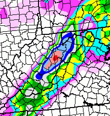
skier219 - did I understand you correctly that Snowshoe could get up to 16" of snow by this weekend?
I see the NWS is calling for highs in the 40's at Snowshoe through the weekend - when does it look like the next cold shot will be coming in?
Abe, Thurs-Friday is a big ??? right now. I wouldn't get your hopes up, but at least one of the models puts a 16-18" bullseye on Snowshoe. I used to get excited by stuff like this, but 95% of the time it's usually a bust. The other 5% of the time it's a real jackpot if you can be in the right place at the right time.
Snowshoe will be warm the next 1-2 days, briefly cool down Thurs-Friday (just barely long enough for that 5% jackpot), warm to low 40s by Sunday and stay there until about next Thursday, then cool down again. That's as far out as I can see with any certainty.
It was balmy 61 degrees out there this evening. I sure hope this doesn't stick around for long. I feel uncomfortable when I am outside without a jacket on....
Hmm... I'll definitely try not to get my hopes up! I just have a trip planned for over there this weekend and am hoping for some decent conditions.
I'll certainly be crossing my fingers though

Hey Craig, any bullseyes for the Catskills, esp. Fri-Sun?
Hey Craig, any bullseyes for the Catskills, esp. Fri-Sun?
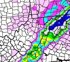
Most of the models are suggesting 6-10" up there, but some models are suggesting heavier amounts (16-20") in the upstate areas and crossing into Vermont.
This is the same NAM run that has the bullseye on Snowshoe:

The thing is, that snow-band line (which stretches from the mid-South to Maine) has a big error band right now, and that affects both the location of the snow band and the amount of snow. I'd say the error band is like 80% right now. So again, don't get your hopes up. I plan to gas up the car, have sandwich fixings in the fridge, and have my skis next to the door just in case. If you have the flexibility to drive North, all the better!
The tail end of this rainstorm will end as a few wet snowflakes late wed & nothing more(Watch out for snowpack melt/Rain flood problems)...Thur storm moves up the coast but will not have enough cold air to tap into the system untill the the main moisture starts moving away which will be around 1 am for snow changeover..thus leaving us once again with having to be happy with the After storm Scraps for fri/sat which as you all know can be a nice treat....As I mentioned to Bushwack a few posts back-Watching NH for a nice Dump...not much for the Catskills or NY areas...
PS..Sue me if I'm wrong!..This is fun playing Fake Weather F-caster

WV ALPPS F-Cast..don't take this too serious..I'm just messing around..FYI
skier219 - or anyone else - where do you find models that show snowfall totals?
This is a good public resource:
http://www.meteo.psu.edu/~gadomski/ewall.html
Ever since Comprex asked the question on the Catskills its been buggin me...Those mtns are on a fine line between a wintry mix & a dump...Comprex must have smelled that...a little shift is all it would take one way or another...J-peak/northern NH is still my dump of the week S-spot...Hope things change for the Alpps!
Check out the cirle for four over Mississippi. With this storm they are poses to get more than most areas along the coast.