|
|
|
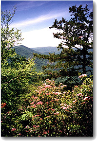
With such a spectacular view, over 100,000 persons hike the mountain each year. But the vast majority of hikers make their ascent in October and November to view the Fall foliage. Last year approximately 32,000 people hiked Old Rag in October and November. However, during the summer wildflower season of June and July, less than 14,000 visited the peak. Thus most people have missed some of the mountain’s greatest treasures: the Trillium, Rosy Azalea, Hydrangea and the legendary blossoms of the Mountain Laurel. “The Mountain Laurel is not only beautiful when viewed in mass,” says Marion Lobstein, author of Finding Wildflowers in the Washington-Baltimore Area, “but the intricacy of the blossom is spectacular when viewed up close. It’s absolutely something everyone should see!”
Unlike many of the other wildflowers, which bloom in the valley and along the trail, the Mountain Laurel grows near the top. To enjoy its beauty you have to step into your hiking boots. The hike along the Ridge Trail to the summit returning via the fire road and Weakly Hollow trail is 7.1 miles. In the good old days prior to 1997, access to the trail was free and you could drive right up to the trailhead. Because it is without a doubt the best and most popular day hike within several hundred miles of DC, this led to an overabundance of hikers wedging their cars in amongst the trees at the end of the road in various bizarre contortions. With the trailhead beginning to look like the aftermath of a hurricane, the National Park Service took action. Now, there’s a $5.00 per hiker fee ($10 for families in one car) and only 12 cars are allowed to park along the side of the road at the beginning of the trail. Everyone else must park in a 200-car lot 0.9 miles from the trailhead. Hence, unless you are an extremely early riser or extremely lucky, there’s now an additional 1.8 miles to trek.
Once you travel the 0.9 miles along the road, you’ll come to a rather ominous sign at the start of the Ridge Trail. It warns against hiking the trail if you have high blood pressure or are without water, food or appropriate footwear. There’s even a warning that falling off the side of the mountain can result in death! This doesn’t seem to be a common occurrence. But many a twisted ankle, scraped and bruised legs and dehydration has fallen on those who are ill prepared. The Ridge Trail to the summit is not just a walk in the woods. Out of shape huffers and puffers should consider one of the alternate, though far less scenic and exciting, routes to the top. For those unfamiliar with day hiking, see Hiking Basics below.
Besides a familiarity with the basics, a hiker also needs to be prepared for a change in the weather.
“One hot spring day last May, my girlfriend Tracy Tuttle and I decided to hike the Old Rag loop trail, says Tom McGowen of Annandelae, VA. “It was our first hike together, and I was interested in how she would do in the woods. We had a nice hike up the mountain and enjoyed a picnic on top while admiring the view.
“However, as we ate, a large storm cloud formed off to our west. I kept my eye on the storm as it moved closer, but we finished lunch and moved off the summit before the storm arrived. About half a mile down from the top, the storm hit. I expected a little rain, but we were hit by a full-blown thunderstorm. Ponchos work great even in downpours, but I have to remember NOT to leave them in the car. It rained hard enough that the trail turned into an ankle deep stream and we got soaked. Tracy remained in good spirits. But rounding one corner of the trail, an animal jumped out from literally under her feet. She screamed and I thought she was being attacked, but what she screamed was ‘It’s a rabbit! It’s a rabbit!’ The rabbit then took off down the trail. After thinking about it a second, we both had a good laugh.”
In addition to these terrifying bunnies, hikers along Old Rag are likely to see wild turkeys, deer, snakes, salamanders, and the occasional black bear.
“Early May of 1997”, says hiker John Alexander of Alexandria,VA, “I was casually strolling along the Ridge Trail about 1/4 to 1/2 mile from the trail head when I heard a loud crashing in the bushes off the trail to the left. When I looked around I was quite surprised to see a large black bear observing me from about 35 yards away. We looked at each other for a moment and then the bear lumbered off with enough speed to make me glad that I hadn’t felt the need to run from it. Not being a bear expert, I couldn’t tell whether it was male or female (there were no cubs with it) but I was impressed by its size. It must have weighed over 300 pounds! Not being inclined to follow it, a big no-no for bear encounters, I remember thinking ‘Wow, that was a bear!’ and continuing up the trail.”
If fortunate, yes fortunate, enough to see a black bear, don’t panic. Dean Ahearn, an experienced Park hiker with a longtime interest in bears whose article about coexisting with them appears on the Potomac Appalachian Trail Club’s Web site (www.patc.net), urges that “if you see a bear, stand your ground but keep your distance, giving the animal all the room it needs. Make sure it can see you; bears don’t like surprises and may react aggressively if suddenly confronted. Don’t yell or jump around to get its attention; just make yourself visible. If I see one at a distance, I may wave my arms slowly to help it see me, but I generally do that only if I’m concerned about an accidental surprise -; if the bear’s near the trail, for instance. If it seems to be acting threateningly, back off a bit (not fast, and don’t turn your back) Most bear charges, by blacks and grizzlies, are bluffs. If you stand your ground -; which, granted, may take more nerve than you knew you had -; it’s likely the bear will abort the charge. Don’t run. You couldn’t outrun ‘em anyway, and you just about never have to.”
And speaking of being a bear in the woods, should one find need to imitate one of the habits of the beast, treat the trail with care. Urine, unless concentrated in large quantities in a small area, is sterile and does not have a great impact on the environment. But other human by-products, especially on busy trails, can be detrimental. Thus if you need to be “a bear in the woods”, find a remote area (away from any streams or sources of water), use a trough or stick to dig a small hole and be sure to cover the hole with dirt before returning to the hike. “Treat the surroundings with the same respect that you would expect of a guest in your home,” says Michael Karpie, a Potomac Appalachian Trail Club (PATC) District Trails Manager. “And remember this: most of the trails you are walking are maintained by volunteer effort.”
Finally-; to the hike, the Ridge Trail begins with a long series of switchbacks deep within the forest. Along the path, you’ll pass small blue flowers that carpet the undergrowth, which are frequently referred to as Seas of Bluets. The beauty and serenity of this environment can sometimes lead to bouts of profound eloquence… and sometimes not. “This hike is like uphill all the way”, remarked Chris Schwartz, of Davidsonville, Maryland on his first trip up the mountain.
After about 1.25 miles, you pass some very large flat stones off the trail to the right. These massive rocks make an excellent spot to take a break and enjoy the solitude of the woods. For late starters, this is also a great lunch stop before reaching the more difficult areas of the hike. At 1.5 miles, the forest gives way to hemlock and brush and then barren rock. Old Rag derives its name from the rock covered raggedy appearance of the summit. To stay on the trail, follow the blue blazes painted on the rock.
Another quarter mile will bring you to the first, of what seems to be endless, feats of scrambling. “I remember hiking this as a small child and being amazed at the sizes of the boulders and the crevasses in the rocks,” says Karen Carra, of Takoma Park, MD. “I took my husband on the hike when we were first married and he thought that I had been exaggerating about the sizes of the rocks and that my memories were based upon a childhood perceptions. But as we cleared the brush and began scrambling, I realized that my memories were no exaggerations. My husband had to eat his words and couldn’t believe a small child could have climbed over the boulders we were now barely bellying up over.”
|
|
|
The trail continues to the right through a low passage under a leaning boulder. “I overheard one hiker call this upcoming squeeze space ‘Crisco Alley’ as we patiently waited for a long line of people in front of us to suck in their bellies and walk through the rock walls sideways”, says PATC member Norma Gonzolez of Reston, Virginia. Follow the blue blazes to the right and then to the left to another “Lava Dike”. For shorter persons, this dike is quite a challenge since one must surmount a nearly five foot high ledge. For those with climbing experience, you can chimney up the walls of the narrow corridor. For others, a boost from a fellow hiker may be required.
Upon exiting the dike, you will be treated to fantastic views of the farm country to the Southeast and a short rest from scrambling as the trail follows a long ramp of rocks. But as you gain altitude, you will be lulled by a series of false summits while continuing to rock scramble and climb over giant boulders.
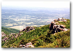
Finally after hiking about 3 miles and gaining 2300’ in altitude, the 3291’ summit is yours. Standing atop the granite you have a panoramic view of Skyline Drive and the farm country of Western Virginia.
The granite that forms the top of Old Rag comes from magna that forms a base of the continental crust in Virginia. Its exposure, giving the mountain the raggedy appearance, is due to millions of years of erosion. The granite is laced with blue quartz that includes trace amounts of titanium giving the granite a bright highly reflective hue. The cream-colored shapes and patterns in the rock come from feldspars that formed with the granite when the magma cooled.
One could easily spend all day relaxing on the rocks and basking in the glorious views. But though camping is permitted on Old Rag, unfortunately it is not allowed at above 2800’. Plus, there are still another 5 miles to finish the circuit hike. Finding the trail again requires a bit of hunting about for the blue blazes on the rocks near the summit. Once found, the blazes lead down through the boulders to the Saddle Trail. Here, you’ll finally find the magnificent Mountain Laurels. The Mountain Laurel (KALMIA latifoila L.) is named after a Finnish botanist Peter Kalm who was the first to study the genus. These white flowers with pink dots are unique in their construction. Shaped like a ballerina’s skirt, the blossom has stamens that are bent back and pop forward when visited by a pollinator. With the ten stamens and the shape of the blossom, the flower has the appearance of a delicate parasol.
Returning to the hike, the Saddle Trail continues into the woods via a stone staircase and a series of switchbacks until reaching the Bird’s Nest Shelter No.1. This shelter is for use only during the day and is of little functionality during the hike. Follow the blazes to the right at the fork in the trail and back into the deep forest. At 4 and a quarter miles, you’ll come to another day-use shelter: The Old Rag shelter. This hut makes another nice rest stop and is often surrounded by various wild flowers including the Trillium . At the next junction point, turn right onto the Old Rag fire road and then right again onto Weakly Hollow Road.
Many hikers consider this long flat hike back to the trailhead to be rather boring. But as you look through the trees to the right you’ll catch glimpses and open views of Old Rag in all its glory. With the late day sun striking on the rocky summit, the façade sometimes glows in orange. Along the Weakely Hollow Road you’ll pass trail markers for other trails (such as the Robertson Man and Corbon Hollow Trail) as well as designated campsites for Shenandoah National Park. Yellow Pimpernels, Golden Alexanders and other blossoms can also be found along the trail. Over 160 wildflowers, trees and shrubs are in bloom in June and July in the Shenandoah National Park.
The Shenandoah National Park (SNP) was authorized by Congress in 1926 and dedicated in 1935. To create the park, nearly 80,000 acres of land had to be acquired. This resulted in the purchasing of great tracts from various landowners and their subsequent relocation. Many of the foundations of the original town of Old Rag can be found in the woods adjacent the Weakley Hollow Trail. For those who want to embark on a less traveled hike and pursue the history of the mountain, check out “The 18 Cabins of Old Rag-A Field Guide for Bushwhackers”, by Leonard F. Wheat, which is available at the PATC Headquarters in Vienna, VA. PATC was also instrumental in promoting the establishment of SNP and built many of the trails within the park- current members work year round to maintain and improve them.
Before reaching the end of the hike, you’ll cross several wooden and metal bridges that cross the Brokenback Run. These bridges, deep in the canopy of the trees, with the bubbling creek make an ideal romantic setting.
|
|
|
Crossing the last of these bridges, you’ll finally return to the beginning of the trail and have .9 miles of an easy walk back to the parking lot -; a walk usually spent on talking about the adventures of the hike. “Anyone who doesn’t have an Old Rag story either hasn’t been up there enough or wasn’t paying attention when they were,” says bear aficionado Dean Ahearn.
For the less physically abled, a shorter trip to the summit can be had via the Berry Hollow Fire Road. From Sperryville (see Directions), take Rt. 231 South 11 miles and turn right onto Rt. 643. Go 15.5 miles and turn right onto Rt. 600. Go about 20 miles until the pavement turns to a gravel road and park at the end of the road. The parking lot holds 20 cars at most. SNP also collects a fee for use of this trail.. Hike up the road on the right until reaching the Saddle Trail and turn right to take the Saddle Trail to the summit-total hike to top: 2.8 miles.
To get to the parking lot for the Ridge Trail, follow I-66 West to Exit 43A, Take Route 29 South towards Warrenton and bear right onto Rt. 29/211 West, which then becomes just 211 West. Go approximately 27 miles to Sperryville and then turn left onto Route 522 South. After a mile, turn right onto Rt. 231. Follow 231 for about 8 miles and turn right onto Rt. 601-there’s a sign for Old Rag. Go across a bridge and follow the signs to stay on Rt. 601/707/600. The parking lot is on the left 3 miles after you turn onto 601.
Remember, the parking lot only holds 200 cars, so when it’s full, no one may enter the park until someone else leaves. It is therefore recommended that you visit Old Rag on weekdays to avoid the crowds. The entrance fee is paid at the kiosk in the lot.
Since you’ll be on your feet all day, (total hiking time for Old Rag ranges from 5-8 hours), preparation begins with a good pair of hiking boots and hiking socks. Sneakers don’t provide the necessary traction for the rock scrambling at the top of the hike. Nor do they offer any ankle protection like a decent pair of boots. Hiking boots can cost upwards of several hundred dollars. But a good pair of lightweight hikers can be purchased for less than $40.00 on sale. A pair of waterproof boots can often be found for under $80.00. Hiking socks are recommended since they provide additional shock absorption that cotton socks don’t. Look for a pair that wick the perspiration away from your feet, such as Thorlos. Hiking socks cost about $8-12/pair.
The second most important item is water. “I like to bring a little more than I plan on needing,” says Michael Karpie, of PATC. “During my last hike one of the members of our group got separated from the rest and two of us ended up hiking an extra six to eight miles searching for this individual. The extra water came in handy”. For day hiking, a canteen or several water bottles on a belt will suffice. But a hydration pack, such as a Camelback, makes it much easier to re-hydrate.
Hydration packs have a flexible tube that ends in a bite valve. The pack is worn like a backpack with the tube and valve hanging over your shoulder near your chest. By biting down on the valve (hence the name), you drink from the tube as if it were a straw. Hydration packs are also usually insulated to keep the water cool. The more expensive ones have a small built-in backpack to carry your other essentials, which include: lunch, compact binoculars, a camera, sunscreen, sunglasses, biodegradable camper’s toilet paper and a small hikers first aid kit. Though not really needed for the hike on Old Rag, a trail map is also not a bad idea. If you’re serious about hiking, a good hydration pack is a must.
If you don’t own a hydration pack, a simple backpack will do. Camera vests are also great because you can store all of your gear in the multitude of pockets.
To avoid being eaten by nature’s smaller creatures, a coating of insect repellent is also essential. Insect repellent is your second best protection against ticks carrying Lyme disease. The best protection is clothing. A pair of breathable micro-fiber pants, such as made of Supplex, will keep you as cool as shorts and protect you not only from ticks and other insects, but will keep your skin covered from brushing up against poison ivy and other nasty weeds. Remember the old adage, “If leaflets be three, let it be!”
Another defense against Lyme disease is the vaccine Lymerix. But the FDA only recommends this for persons spending a great deal of time outdoors in tick-infested areas. There are also creams that guard against poison ivy. But with the sunscreen and insect repellent, adding another chemical to your skin doesn’t seem like a good idea. Though there are some lotions that combine sunscreen and poison ivy repellent, as well as sunscreen and insect repellent.
If you think that you’ve come into contact with poison ivy, it’s best just to wash with a product called Tecnu soap. This soap dissolves the oils left behind from contact with poison ivy. Treatment with Tecnu is effective up to 8 hours after suspected contact with poison ivy, poison oak, etc. The soap can be purchased at any drugstore for just a few dollars. After hiking, also perform a thorough check for ticks. If you do find a tick, this doesn’t mean that you’ve contracted Lyme disease. NIH studies have shown that it takes many, many hours for a tick to transmit the bacterium that causes Lyme disease. Carefully remove the tick with a pair of tweezers, insuring that you’ve pulled out the head, and then disinfect the bite area.
For more info on hikes in SNP, see-;
75 Hikes in Virginia’s Shenandoah National Park, by Russ Manning or
Circuit Hikes in SNP, published by PATC.
Or contact PATC at:
118 Park Street, S.E.
Vienna, VA 22180
703-242-0693
www.patc.net
For info on wildflowers, see-;
Wildflowers of the Shenandoah Valley and the Blue Ridge Mountains, by Oscar W. Gupton or
Finding Wildflowers in the Washington-Baltimore Area, by Marion Lobstein, who also conducts wildflower tours in association with the Smithsonian.
Or visit the arboretum of the Virginia Native Plant Society in Boyce, VA 540-837-1758,
www.vnps.org
Matthew Graham is a skier as well as a hang glider and paraglider pilot, SCUBA diver, cavern diver, equestrian, polo player, sailor, hiker, biker, rock climber, paddler, and skater. He's also yoga teacher and certified personal trainer and has dabbled in just about every other sport, even stunt car driving and bull riding! He has written for the Washington Post, Washingtonian Magazine, USA Weekend Magazine, Hooked on the Outdoors, Richmond Magazine, Chesapeake Life Magazine, Metro Sports, American Fitness, Blue Ridge Outdoors, Recreation News and numerous other outdoor and travel publications.


Join the conversation by logging in.
Don't have an account? Create one here.