where is it? picture thread
25 posts
10 users
6k+ views
crunchy
September 4, 2007
Member since 02/22/2007 🔗
596 posts
fun idea for a thread, altho I will probably not guess most unless they are in the Shenandoah's or the valley \:\)

this is probably fairly easy:


only andy will know this one tho :P

David
September 4, 2007
Member since 06/28/2004 🔗
2,444 posts
The first one was taken in a Pre-Cambrian forest apx. 550 mya???

Ok, maybe Red Creek somewhere.....
kwillg6
September 4, 2007
Member since 01/18/2005 🔗
2,066 posts
The second one looks like a section down near smoke hole where I did a float one time. The first one????
wvrocks
September 4, 2007
Member since 11/9/2004 🔗
262 posts
First one looks like Red Run above Wilderness Loop Road. Possibly Devils Run near Davis

Second looks like the Grover Hole on Dryfork down near Jenningston. Here it is at slightly higher flows during a Swiftwater Operations class.

DCSki Sponsor: Past Yonder: A Human's Views on AI
crunchy
September 4, 2007
Member since 02/22/2007 🔗
596 posts
nice wvrocks, the first is a little crossing on dunkenbarger trail in dsods wilderness area. didnt know the name, but it feeds into red creek.

the second is off gladwin rd above jenningston. (rt72->jenningston rd->gladwin rd) cant really tell in the pic but those are ledges you can climb onto, and dive off of. the hole is pretty deep and clear \:\) Props to fishnski for the hookup on that one!
wvrocks
September 4, 2007
Member since 11/9/2004 🔗
262 posts
Yeah its a pretty cool place. Lots of people there in the summer.

Since I got one right I'll take the liberty of adding a couple more.

I was just at both of these places last week.

crunchy
September 4, 2007
Member since 02/22/2007 🔗
596 posts
half dome? YNP?
wvrocks
September 4, 2007
Member since 11/9/2004 🔗
262 posts
Yep, cables on the way up Half Dome. 2nd is Catherdal Lake and Catherdral Peak from the John Muir Trail.
David
September 4, 2007
Member since 06/28/2004 🔗
2,444 posts
 Originally Posted By: wvrocks
2nd is Catherdal Lake and Catherdral Peak from the John Muir Trail.


That picture is BEAUTIFUL!!!
wvrocks
September 4, 2007
Member since 11/9/2004 🔗
262 posts
Thanks, honestly the picture doesn't quite do the view justice. Its just a stunning area.
David
September 4, 2007
Member since 06/28/2004 🔗
2,444 posts
Here is a pic...this pic was taken from the top of what ski resort???


RiverHill
September 5, 2007
Member since 01/16/2005 🔗
28 posts
Where is half dome? Those cables look like something fun to try.
wvrocks
September 5, 2007
Member since 11/9/2004 🔗
262 posts
Its in Yosemite National Park in CA. Its about a 14 mile roundtrip with over 4800 ft of vertical ascent. Its a slog. Luckily we were passing through the area and did it as a side trip so it only added 4 miles to our day.

When you get to the top of the lower summit before the cables
they are very intimidating. They basically look vertical. From the bottom of the cables it looks better but its still very steep and the granite is a bit polished. Honestly after doing it I'm suprized the NPS allows it. Even with the cables its very exposed and crowds make it more dangerous. We talked with some people from Yosemite Search and Rescue and they said basically the NPS still does it because to change it would open them up to lawsuits from past accidents. All that considered, if I ever go back I'd do it again.
wvrocks
September 5, 2007
Member since 11/9/2004 🔗
262 posts
Can't see your pic David
crunchy
September 5, 2007
Member since 02/22/2007 🔗
596 posts
sugarbush?
The Colonel - DCSki Supporter 
September 5, 2007
Member since 03/5/2004 🔗
3,110 posts
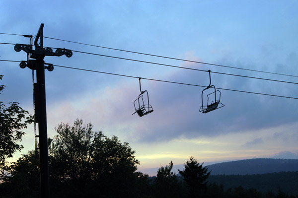
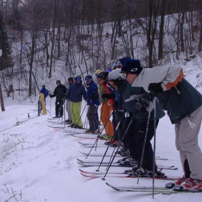
No question, it is one of five places, assuming you took the picture: WV: Canaan, Timberline, Snowshoe; MD: Wisp
VT: Killington. These were the areas you said you had skied during my April poll! I would guess either Snowshoe or Killington! Since the buildings and roads in the valley appear mmore extensive than at the bottom of the Shoe, I will have to say, Killington! Too bad the picture did not have more resolution for a better blow-up of the valley area! But it sure does look like the top of Cup at Snowshoe!?
The Colonel \:\)
David
September 5, 2007
Member since 06/28/2004 🔗
2,444 posts
 Originally Posted By: The Colonel
Since the buildings and roads in the valley appear mmore extensive than at the bottom of the Shoe, I will have to say, Killington!


Great guess! It was taken right as you come down from the top of the K1 Gondola....I can't believe you used a previous post against me!!!
SkiBumMSP
September 7, 2007
Member since 12/8/2004 🔗
224 posts
My turn! Some little town out in California that I was at earlier this summer, which had this really cool bridge that was a pretty cool to walk across :

The Colonel - DCSki Supporter 
September 8, 2007
Member since 03/5/2004 🔗
3,110 posts
Hi Steve,
Picts of the Golden Gate Bridge and the San Fran skyline.
The Colonel \:\)
Scott - DCSki Editor
September 8, 2007
Member since 10/10/1999 🔗
1,249 posts
OK, I have some. Guess the following five locations:


SkiBumMSP
September 8, 2007
Member since 12/8/2004 🔗
224 posts
 Originally Posted By: The Colonel
Hi Steve,
Picts of the Golden Gate Bridge and the San Fran skyline.
The Colonel \:\)


Yeah, that one was a 'gimmi' After all, who would not be able to recognize something as distinctive as San Francisco and the Golden Gate Bridge? ;\)

Okay, here is something a bit more difficult (the second picture is a pretty big clue if you are familiar with the area):

Roger Z
September 9, 2007
Member since 01/16/2004 🔗
2,181 posts
Potomac River just above the American Legion bridge?
JohnL
September 9, 2007
Member since 01/6/2000 🔗
3,551 posts
 Quote:
Potomac River just above the American Legion bridge?


One of my first thoughts, but the bridges are too narrow and not that close together. When driving across the A-L bridge, you can barely tell you are on a bridge. Of course, I may be totally wrong...

One of the bridges on Corr-H?
SkiBumMSP
September 9, 2007
Member since 12/8/2004 🔗
224 posts
 Originally Posted By: JohnL
 Quote:
Potomac River just above the American Legion bridge?


One of my first thoughts, but the bridges are too narrow and not that close together. When driving across the A-L bridge, you can barely tell you are on a bridge. Of course, I may be totally wrong...

One of the bridges on Corr-H?


That is the Rappahannock River right here in Good ol' Fredericksburg, VA. The bridges is the I-95 bridge that crosses the Rappahannock immediately north of Fredericksburg.
Roger Z
September 10, 2007
Member since 01/16/2004 🔗
2,181 posts
Dang, that was my next guess, based entirely on your signature. \:\)

Ski and Tell

Snowcat got your tongue?

Join the conversation by logging in.

Don't have an account? Create one here.

0.16 seconds