The Snow Sports Museum of West Virginia has been researching lost ski areas in the mountain state. We have bee interviewing individuals who are knowledgable about what happened and when. Another mountain which had grand plans and was being developed by people associated with Snowshoe and Tory was Job Knob, just southeast of Harmon, WV. It would have had a peak elevation of 4445 and a vertical of over 900'. It was just south of the lost ski area of Tory or Briar Patch Mountain. The concept study which I am reading from proposed development of 575 acres in townhouses, condos, single family detached and a village with another 350 acres used for skiing, golf and a 3000' airstrip. The ski area was to be operational in 1973 and the golf course in 1974. This proposal was under construction in 1972 but lack of capital caused it to be abandoned. It would have proceeded Snowshoe by a year.
Confused..
Are you saying that Tory Mt was on Briar Patch Mountain, and NOT Job Knob?
kwillg6 wrote:
The Snow Sports Museum of West Virginia has been researching lost ski areas in the mountain state. We have bee interviewing individuals who are knowledgable about what happened and when. Another mountain which had grand plans and was being developed by people associated with Snowshoe and Tory was Job Knob, just southeast of Harmon, WV. It would have had a peak elevation of 4445 and a vertical of over 900'. It was just south of the lost ski area of Tory or Briar Patch Mountain. The concept study which I am reading from proposed development of 575 acres in townhouses, condos, single family detached and a village with another 350 acres used for skiing, golf and a 3000' airstrip. The ski area was to be operational in 1973 and the golf course in 1974. This proposal was under construction in 1972 but lack of capital caused it to be abandoned. It would have proceeded Snowshoe by a year.
Wow.. You learn something new every day. I have been going by google maps and the USGS topos.
I can see the trails cut into the northern slope of job knob, but not any signs of slopes cut on Briarpatch. 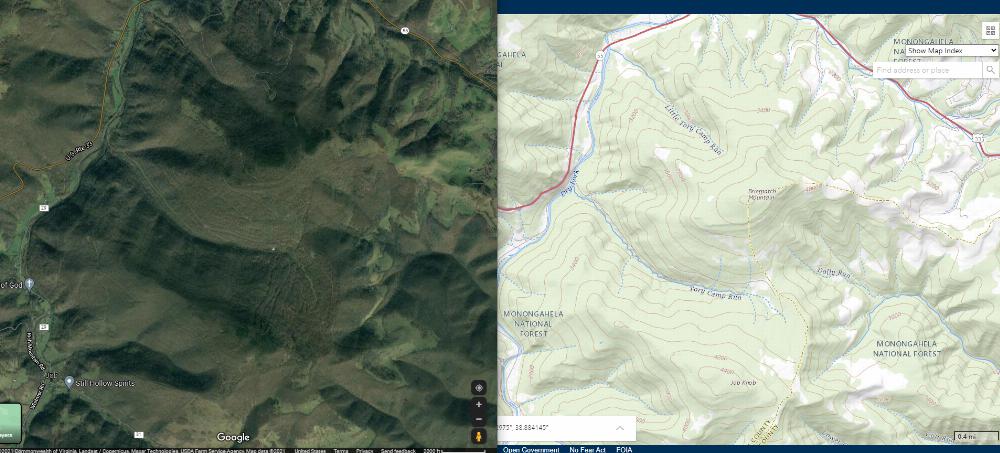
kwillg6 wrote:
Exactly. Briar Patch can be seen from route 33 as you cross Allegheny which was Tory. The runs were cut in the early 80s. Job Knob was being developed back in the early 70s. Both failed due to lack of capital. We gleaned this from Danny Seme couple of weeks ago. He was a CEO of Snowshoe in the 80s and 90s and helped Dr. Brigham develop the shoe. There were other developments considered for the Potomac Highlands as well.


Join the conversation by logging in.
Don't have an account? Create one here.
