Country Roads: What Every Skier Should Know About Driving to West Virginia’s Slopes
25
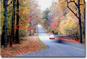
Since 2001, I have driven from Washington to the Timberline Four Season resort in the Canaan Valley of West Virginia over fifty times. Like Merywether Lewis and William Clark, I continually hope to find the elusive “northwest passage” to West Virginia ski country: a fast, efficient road with few switchbacks. With every new route I take, my hopes are dashed. The Allegheny Mountains and the small roads over them make it impossible for me to get to my Timberline condo in less than four hours. In the words of a recent West Virginia Department of Transportation white paper, getting from the metropolitan Washington area to the Canaan Valley requires drivers to endure “many miles of narrow, twisting two-lane highways that are mountainous, treacherous in bad weather and time consuming to travel.” Almost heaven they are not.
But there is hope. The state is currently building a new 100-mile long four-lane highway from Elkins to the Virginia state line called Corridor H. The road will cost state and federal taxpayers over $11 million per mile to construct, but in the end it promises to promote social and economic development throughout the region. For skiers, it may become West Virginia’s version of “Ski 93” in New Hampshire, or I-70 in Colorado - a high speed expressway to powder. As of the publication date of this article, though, only 13.5 miles of the road have been finished, so it will be many years before Corridor H obviates the need for skiers to travel along some of the state’s many country roads.
So what’s the best route to the major West Virginia resorts as of October, 2003? The answer depends on where you live and where you want to go.
Snowshoe
DCSki columnist Lou Botta goes to Snowshoe nearly every weekend and therefore I defer to his advice for this mountain. Lou claims that the best route from the metropolitan DC area to Snowshoe is:
I-66 to I-81
I-81 until the Strasburg exit (only 3 miles) to Hwy 55 West
Hwy 55 West (through Wardensville) to Morefield, left at Hwy 28
Hwy 28 all the way down to 1 mile past Greenbank (Local Hwy 66)
66 through Cass and the back way to Snowshoe
According to Lou, this route “goes through the thinnest part of the Alleghenies, and therefore you get to cross only two ranges (I brought a barometer) at the 2,000 and 2,900 foot level with mostly easier curves” than highway 250, the alternate route. Highway 250, by contrast, is a truck route that climbs up and down seven ranges - some of which contain 4,000 foot peaks. With minimal stops, the 55 route takes approximately five hours. Drivers on 55 also can currently enjoy 8.5 miles of new Corridor H four lane highway from between Moorfield and Baker - the entire 14 mile section should open by the 2003-04 ski season.
A variation on the route listed above is to exit 28 at Seneca Rocks and then take 33 to Elkins, followed by 219 south to Snowshoe. The new access road to Snowshoe from Cass obviates the need to take this alternative unless you are staying at some of the cheaper motels in Elkins, 48 miles from Snowshoe.
Save your appetite for Snowshoe because all the best restaurants are located there, including Cheat Mountain Pizza, Red Fox, and Auntie’s Pasta. A good grocery stop is the Food Lion in Petersburg, and there also some fast food restaurants there. Skiers also can find most grocery items they will need at the various convenience stores at the resort.
Speed traps can occasionally be found in Baker, and Moorfield, West Virginia, and drivers should take great care driving through Wardensville - the most notorious trap along this route.
Timberline/Canaan Valley: A Route for DC and MD Skiers
For skiers living north of the Potomac River in the District of Columbia and Maryland, my experience suggests that the fastest route to Timberline is as follows:
I-270 to Frederick
I-70 to Hancock
I-68 to Cumberland
Exit on US-220 South on the outskirts of Cumberland
Route 220 South to Route 50 West at New Creek, West Virginia
Right on SR-93 just beyond New Creek
Left on SR-32 at Davis
Follow 32 to Timberline or Canaan Valley
The drive takes me four hours with limited stops. Two and a half hours of that time are on relatively traffic free, scenic interstate highways in central and western Maryland. The only difficult climb is the four miles of switchbacks on SR-93 between Scherr and Bismarck, West Virginia.
Along the entire route, my favorite restaurants are Mr. Tucker’s on Naves Cross road just before Cumberland, the Chat N Chew diner in McCoole, Maryland, and for late night bites, the 24-hour Denny’s in Keyser, West Virginia. A Wal-Mart Super Center can be found in New Creek and a 24-hour Martin’s grocery store in Keyser. Rest areas with bathrooms can be found on I-70 at South Mountain just before Hagerstown and on I-68 at Sideling Hill just beyond Hancock. It was at the east South Mountain rest stop that police finally apprehended the notorious DC Sniper last October. Despite this negative publicity, the stop is usually filled with travelers and quite safe.
There are some distinct drawbacks, however, to this route. Traffic on I-270 can be messy during peak travel times, especially along the narrower four-lane stretch approaching the city of Frederick. Traffic and weather conditions on I-270 and all other major Maryland interstates can be checked using the CHART (Coordinated Highways Action Response Team) web site. For the skier, CHART’s interactive mapping system can be a blessing in bad weather. The map employs roadside sensors to provide users with real time information on highway speed, road temperature, air temperature, dew point, wind speed, precipitation, and a variety of other vital information. The West Virginia and Virginia departments of transportation also offer valuable information on road conditions in those respective states via their web sites. (See Related Links at the end of this article.)
Once off the interstate system, drivers can occasionally hit some traffic on US-220 in Cresaptown, MD, or Keyser, WV. Cresaptown/Jessup/Cumberland region is host to one of the biggest growth industries in Appalachia: prisons. There are eleven state and one federal correctional facility in the area. According to the Cumberland-Times, prisons pump over $50 million into the local economy in salaries alone.
After Keyser, the road becomes desolate. The West Virginia State Police occasionally set up a speed trap on the lonely stretch of SR-93 between Claysville and Scherr. The four-mile climb up the Allegheny Front on 93 is the toughest part of this route: my cockatiel Franz usually whines for the entire ascent. There is no passing lane on this climb so if you get behind a truck, it can go very slowly.
Unless there is a regional blizzard, snow is rarely a problem on the drive until you get beyond the Allegheny Front - a steep escarpment that forms the dividing line between Mid-Atlantic and Midwestern weather. Because the higher west side of this front is colder and wetter than the eastern side, the Allegheny Front is the most significant snow line in the region. It’s also the reason why resorts like Snowshoe and Timberline have much longer seasons and better natural snow than resorts closer to DC. On one trip in late March, I literally witnessed rain turn to snow on the final switchbacks of my climb up 93 to Bismarck.
Once west of the front, you can expect snow at anytime between October and April. The 16.6-mile stretch of 93 between Bismarck to Davis along the Allegheny plateau can be treacherous not only during a major storm but long afterwards due to blowing and drifting snow and occasional lake effect snow. Fog (especially freezing fog) and abundant deer pose additional challenges for drivers at all times of the year.
To avoid this stretch of 93 during a snowfall, some drivers take US-219 north via Oakland, MD, and the Deep Creek resort. This stretch of road is indeed more protected by trees and does not contain as many switchbacks as 93, but West Virginia also does not plow it as frequently, and therefore, 93 is still the better route.
One last point to bear in mind: when you finally get to Davis, you are still twelve miles from the Timberline and Canaan Valley ski areas. Therefore, if you need food or fuel, this is your final opportunity to stock up before you hit the slopes: a few basic items such as milk and beer can be purchased at the Deerfield Village Store, but for gas or most grocery items, you will have to drive back to Davis. The Canaan Valley Exxon recently closed and may not reopen prior to ski season. Also, while both Shop & Save and the Deerfield store sell wine and beer, neither sell harder spirits.
Timberline/Canaan Valley: The Virginia Dilemma
Skiers who come from Virginia have a greater variety of choices than the Maryland/DC crowd, and as a consequence, I hesitate to recommend one route over another for them. Some skiers from Virginia actually travel the Maryland route because they wish to avoid mountain roads for as long as possible: the two major Virginia routes require far more back road driving.
That being said, those byways can save the Virginia driver some valuable time, especially as more of the new Corridor H gets completed. For now, however, the most direct route is similar to the Snowshoe route:
I-66 to I-81
I-81 until the Strasburg exit (only 3 miles) to Hwy 55 West
Left at Moorfield on 28.
28 to Seneca Rocks, right on 33 West.
At Harman, veer to the right onto Route 32. (Route 32 starts in Harman and runs North through the Canaan Valley to Thomas, just north of Davis.)
The toughest climb is on 33 just beyond Seneca Rocks, where the road goes up the Allegheny Front, but this ascent is easier than the one on 93 because there is a passing lane on portions of this road.
As far as amenities are concerned, Petersburg has the greatest selection of restaurants and also a large Food Lion. The Golden Anchor on 32 just south of the Canaan Valley offers magnificent views of Mount Porte Crayon and decent, albeit slightly expensive, seafood entrees. Big John’s Family Fixin’s in the Canaan Valley is another good bet for pizza and other basic entrees. The best rest stop along the route is the visitor’s center at Seneca Rocks.
An alternative to SR-55 is US-50 from Winchester to New Creek and then SR-93 and SR-32 to the land of milk and honey. Some skiers swear by this route.
Getting to Winchester from the Northern Virginia suburbs is easier than getting to Strassburg (the exit for 55) because it served by the Dulles Greenway and Route 7 - roads that generally carry less traffic than I-66. 50 is also less hilly than 55, and contains extra passing lanes in several sections. However, it is also longer. Food can be purchased along 50 at the Sheetz gas station or Dairy Queen in Romney. The Wal-Mart Super Center in New Creek is not far from the junction of 50 and US-220.
For the DC or Maryland based driver, the most arduous aspect of the Virginia routes is not the switchbacks, but the inconvenience of escaping westward from the metropolitan area via the Virginia highways. DC drivers must confront nearly constant traffic on I-66 from Ballston to West Falls Church. Whatever time is saved on US-50 or SR-55 is inevitably squandered on this short stretch of backed up highway. Maryland drivers have to fight their way west on the Capital Beltway across the American Legion Bridge - another miserable area of congestion. As more and more of Corridor H gets completed, many skiers who live north of the Potomac will eventually switch over to the SR-55 route, but for now, traffic issues related to getting out of the city make the Maryland route to the Canaan Valley more attractive.
A warning to the wise: Wardensville has gained a national reputation for the prolific nature in which it hands out speeding violations. The speed limit drops from 55 to 25. If you are going 26 at that magic moment, you will get a ticket. If you are going 20, you may get a ticket for driving too slow. If you have out of state tags and a ski rack on your car, your chances of getting a ticket will go up dramatically -- since you won't be likely to return to fight the ticket. Handing out tickets seems to be the town's chosen revenue source, and for that reason, I take the longer, scenic route to Snowshoe (250) and avoid the town altogether.
Living in damascus,md I used the (northern route)but i think you missed out the short jog on 50 before you take a LEFT on 93.Have the roads changed? When i lived in beltsville,md the fastest way for me living on the beltway there was to take the dulles toll & extention to leesburg,go around winchester to 522to 127 which basically turned into 29 which linked back up with 50.This is straighter & faster than staying on 50
Well, Scott, Route 55 has Wardensville, Route 250 has Monterey... I wonder which one has the most citation-profligate police... And both are roughly in the same valley, just 100 miles north-south from each other... And in both, coming from the West, one is going down a steep downhill and into the radar locks of the local tax collector.
The good thing is that Wardensville will soon become the ghost town it needs to be (thanks to its police) once the highway 55 is complete through the town in a year or two. Then the only reason for Wardensville will be as a... for.... let's see... Can anyone find a reason to stop at Wardensville?
Knock on wood - Have never been the unhappy recipient of "green stamps" at the hands of the Wardensville gendarmerie...
My tactic as in virtually everywhere I go, is that once I hit a populated area, I slow down to the posted limit. Both Monterey and Wardensville have nefarious antecedents in the traffic citation department
Andy:
I did leave out a bullet for the MD directions. Scott should have an updated version of the article posted soon. Sorry about that.
John
Fron downtown Baltimore it is 4:15 taking the "northern passage" to Davis.
This is with clear roads, light traffic, speeding moderately.
Of course, there are variables that can change this drastically.
Corridor H will not effect this at all, and I suspect most marylanders will want to avoid this route simply b/c of the traffic in VA - but the DC/Northern VA crowd will benefit.
One option I did not mention is flying. The Canaan Valley has a small, unmanned airport called Windwood. My friend flew from Laurel to Windwood in a Cessna 140 this weekend. It took him 1.5 hours. Windwood operates a small hotel and apparently has some rental cars. They also might be able to arrange a shuttle to Timberline for skiers.
The runway does get plowed in the winter, but I suspect getting stuck because of weather is a very real possibility. Clear days in the winter are a rarity in the CV. My friend will make an attempt to fly in for day of skiing this winter. Ill let everyone know how it turns out.
We also take the northern passage on our trips to Snowshoe. Even though we work in Arlington we have found that its much faster to head over the American Legion and up to Cumberland before turning south to Elkins via Davis ... the traffic on 66 west in the afternoon it truly hellacious. The total trip time for the northern route is within 15 minutes of the pseudo Corridor H. The section through the Alleghenies isnt too bad since the roads are usually cleared for the logging trucks.
If the weather is -really- bad (heavy snow, ice, rain, etc) we continue past Cumberland taking 68 to 79 South to Weston then head east on 33 to Elkins. This adds approx 30-45 minutes to the trip but its 4 lane all the way and kept clear ... leaving only 40 some miles of 219 South between Elkins and Snowshoe. I much prefer to take the few extra minutes of travel time on cleared road versus white-knuckling it thru hours of foggy, icy switchbacks.
Sigh ... can't wait until Corridor H is finished. We love to ski WV but getting tired of the price we pay just to get there. Since we usually cut out a few hours early from work to got out for a long weekend, traveling some of those roads in the dark is definitely not fun.
Just my few cents worth.
Would the dev of a ski resort in the porte crayon area Have an effect on the windwood.I mean can they expand? what are thier limitations? Did you ever see the guy who used to helicopter in to timberline? Who was he?Inquiring minds want to know
When I was at Windwood on Saturday, I noticed that the runway was newly paved, and that the hotel appeared to be newly renovated. That's a good sign.
It would be fabulous if someone started a charter operation out of that airfield. Weather, however, seems to be the BIG obstacle. 150 inches of snow, fog, and lots of rain don't make for good flying conditions.
For more specs on Windwood:
http://www.airnav.com/airport/WV62
snowcone
The Cumberland to CVSP segment is 77 miles, taking the road past Mt Storm -220/50/93/42/93/32.
Your segment 68/79/33/32 is 205 miles. Just from Cumberland!
(Bear in mind the Baltimore/DC to CVSP is about 215ish miles via 68 and the Mt. Storm segment.)
How does this only take 45 minutes longer? That is impossible. The math doesn't work out.
For Gatkinso:
Actually it does take not that much additional time because you are able to maintain much higher speeds over a longer distance. Since we go to Snowshoe 4 to 5 times every season we are always looking for the Shangri La route; optimally with the shortest time, least switchbacks, least total aggravation. Which route we take depends on time of day, time available and the weather. Doing Davis to Elkins in daylight in good weather is a lot of fun but at night in freezing rain its a total bummer.
I merely offered some alternatives to the standard routes that we occasionally use.
Maybe someone could make up a table of possible routes to various popular local DC ski destinations (Shoe, CV, Wisp, 7S) and let people decide which works best for them?
I understand about the higher speeds in the interstate.
Even accounting for going slower up mount storm, it is hard to see how you are going to cover the additional 120 miles in 45 minutes.
As long as we're in to math here:
Gatkinso, your question implicitly assumes that he covers the first 77 miles in the same time as you. But he probably goes much faster on those miles, since he is on the interstate. So he makes up some time there, which he adds to the 45 extra mins to cover the remaining 120 miles.
The 45 mins sounds optimistic to me, but not wildly off the mark.
I know... assumptions abound - like the one where I though snowcone was talking about Canaan not S.nowshoe
I only went to Snowshoe once last year, & took Lou's route as listed in the article. The roads were clear going up, & since I have a sports car & drive like Michael Schumacher, I made it in around 3'50" from Falls Church :) However, I think I posted this last year upon returning...if the weather is really bad, I would NOT recommend using the new, back road to Snowshoe. What a deathtrap! There are some serious curves w/ drop-offs that should have guard rails.
Other than that, this is a great route, as long as you make note of the speed trap locations.
Correction on the 55 route to Harman: at Harman, veer to the right (not the left) onto Rt. 32 (Route 32 starts in Harman and runs North through the Canaan Valley to Thomas, just north of Davis)).
I travel the 66/81/55/32 route to the Canaan Valley 2-3 times a month during ski season and regularly make it in 3:45 to 4:00 hours from Rockville, Merryland. Been making this trip for over 20 years and settled on this route a number of years ago as the fastest (even with theWardensville, Moorefield, and Petersburg speed traps.
George:
We'll make that correction. Thanks for pointing it out.
I haven't made it to any of the WV resorts yet (hope to this year), but I noticed one route was left out...perhaps on purpose. I live just west of Leesburg and would definitely recommend Dulles Toll road -greenway-rt7 to winchester to go west for those in VA. However, for those in Maryland, instead of taking 70 from Fredrick to I-81, you can cross the river on rt 15 from Fredrick to Leesburg, then go to winchester.
Another one worth mention is taking rt 340 south (4 lane highway) to rt 7 in berryville and then it's only 20 minutes west on rt 7 to Winchester.
jeremy that is a good way you mentioned, I took that way once and it compared with the other mentioned ways. 7 is a good alternate of 66 is being difficult, but I hear the traffic on 7 can be troublesome too.
True, traffic on 7 is murder if your between Tysons and Leesburg. Even in recent years Leesburg has had traffic issues grow on rt 15/7. However, even on the absolute worst traffic day with snow, accidents, everything, rt 7 is 60 mph from Rt 9 exite (about 2 miles west of Leesburg)to winchester.
i gre up in keyser and the chat n chew is great, but behind it is a place even better. crossing north over the bridge from keyser to mccoole take an immediate left, then another left as the road bends.
at the stop take a right and you will see the Hamburger Haven. best burgers ever. they use meat from wayne's meat market in keyser---- all grain fed cattle. they also have the best french fries with gravy. lol.
The Seneca Rocks route is only one of several alternatives for the southern route. From Petersburg there are two different, vastly different, options. In the late spring, summer, fall one can go south from Petersburg but then take the Dolly Sods unpaved forest road. Take WV 28/55 south to Jordan Run Road. Turn right and go 1 mile to Forest Road 19. Continue to the bridge and paved Laneville Road (WV 45) until you reach WV 32. Turn right and continue to the Valley. Rough but scenic route and cuts off about 20 miles but not time savings.
The more realistic option is to take 42 north from Petersberg to Scherr. Take 93 to Bismark, bearing left at the gas station and continuing on to Davis. Take 32 to the Valley. This route saves about 10 to 15 minutes compared to the Seneca Rocks route and has many fewer switchbacks.
The more realistic option is to take 42 north from Petersberg to Scherr. Take 93 to Bismark, bearing left at the gas station and continuing on to Davis. Take 32 to the Valley. This route saves about 10 to 15 minutes compared to the Seneca Rocks route and has many fewer switchbacks.
Yes, that's the route I'll be taking next weekend. Each time a new section opens on Corridor H., this article needs to be updated.
As for the Dolly Sods road, I suspect as if it becomes much more popular, it will be gated by the Forest Service. Old Timberline owners have been using for years as a wonderful shortcut.
Dr. Frederick Reichle has "coptered" in from Philadelphia since he first came to the Canaan Valley and purchased Timberline in the mid-1980's. He is well known to do virtually any job required including bussing tables in the lodge. Plays a mean fiddle too.
You should make an effort to check some facts before you go pulling comments off this site.
So you don't think workers hired from a different country that work in food service need food handlers cards, or should be tested for tb.
YOu don't think employers should pay taxes on their employess. I bet the state would disagree. Infact, they already did.