 The Global Positioning Systems, or GPS, was originally designed by the U.S. military to keep soldiers from getting lost. Today, GPS is available to everyone through inexpensive handheld receivers. GPS consists of a network of 24 orbiting satellites that continuously send a signal back to earth. Handheld receivers on earth can accurately determine latitude and longitude once they lock on to at least three satellites. GPS is responsible for keeping airplane flights and seagoing vessels on course, but has recently become popular with hikers, bikers, and skiers. In this DCSki Feature, we examine some of the capabilities of GPS receivers and how they might be useful to outdoor recreation enthusiasts.
In 1978, the first GPS satellite was launched into space. Since then, dozens more have been launched, and as older satellites fail they are replaced with new ones. Each GPS satellite sends a signal back to earth containing identifying information, ephemeris data (such as the health of the satellite and current date and time), and almanac data, specifying where the satellite is in its orbit.
By “listening” to this information from at least three satellites, a handheld GPS receiver on earth can determine its terrestrial location with great precision. How? First, a GPS receiver checks the time a signal was transmitted from a satellite against its own clock. By doing this, it determines how long it took the satellite to transmit the signal to earth, and it can consequently determine how far away the satellite is. The GPS receiver is also told where the satellite is supposed to be in orbit. By combining this data with at least two other satellites, the GPS receiver can “triangulate” and figure out its exact location in relation to the satellites. With three satellites, a GPS receiver can determine its two-dimensional location on earth (for example, latitude and longitude). If a receiver locks on to four or more satellites, it can also calculate its position in three dimensions (latitude, longitude, and altitude.)
It only takes a fraction of a second for a GPS signal to travel from space to earth, so it’s important for the times to be extremely accurate. To that end, each GPS satellite has an atomic clock on board. (Unlike your wristwatch, Atomic clocks don’t lose time.) The 24 satellites provide complete coverage: at any given time anywhere on earth, there are at least three GPS satellites hovering above.
Although the signals the GPS satellites send are relatively weak (around 50 watts), they pierce through cloud cover and thus allow navigation when there is zero visibility (for example, when it’s foggy or snowing outside). And they transmit around the clock, so you can navigate even when it’s pitch dark outside. (But they won’t tell you where a cliff is.)
GPS satellites send signals geared towards civilian receivers and military receivers. Civilian-bound signals have a degree of error purposely inserted; military-bound signals do not have this error, but are scrambled. The intentional introduction of error, known as Selective Availability (or SA), decreases the accuracy of civilian receivers by a small amount. Civilian receivers are generally accurate to within 60 to 225 feet. For outdoor recreation purposes, this error is essentially negligible.
 Full-featured handheld GPS receivers are now available for under $200, making them quite affordable. GPS provides for the accurate calculation of latitude and longitude, but today’s GPS receivers take this a step further and offer such capabilities as real-time mapping and even sunset and sunrise calculation. Below, we examine specific capabilities offered by most of today’s low-cost receivers.
All GPS receivers provide latitude, longitude, date and time. (Since the time is derived from the atomic clocks on GPS satellites, your GPS receiver will be the most accurate clock in your house!) When a GPS receiver is in motion, it is capable of providing velocity and compass information. Most GPS receivers also include the ability to display information in a large number of formats.
When a GPS receiver is in motion, it is able to “plot its course” by looking at where it is now in relation to where it was a second ago. Thus, most receivers allow you to graphically plot your course as you move about. Usually you can “zoom in” and “zoom out” to show or hide various levels of detail.
Most GPS receivers have memory and allow you to enter “waypoints.” Waypoints are basically “snapshots” of where you are. As you hike, you might periodically enter waypoints. Later on, you can recall these waypoints. You might want to know the distance to a certain waypoint, for example, or have the GPS receiver automatically lead you to a waypoint. (They’ll tell you what direction you have to go to get back to a waypoint, and tell you how long it will take to get there, based on your current speed.) Usually you can assign small names to waypoints and link waypoints together to create a complete route.
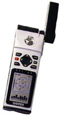
Many GPS receivers include the capability to “direct” you back to a waypoint. For example, the Garmin GPS-45, shown above, has a “moving highway” display that intuitively informs you what direction you need to “steer” to get back on course to a waypoint. It will also tell you how far away the waypoint is and how long it should take to get there.
GPS receivers are in essence computers, and most include an easy-to-use interface. They always have an LCD screen that is capable of displaying large amounts of information in innovative ways. For example, newer Garmin units have a mode that “mimics” a traditional analog compass, showing what direction you’re heading in. Higher-end units even include built-in maps of geographic areas.
GPS receivers are built to withstand lots of abuse. They are rugged and often waterproof. They usually come with a backlit display so they can be used at night. Most have an ergonomic design and fit comfortably in your hand. They can be quite small and lightweight.
Even low-cost GPS receivers offer some nice extras. Some include data ports that allow the receiver to be hooked up to a computer; for example, there are several software packages available for the Macintosh computer that allow easy communication between most GPS receivers and Macs. (You can affordably hook up your GPS receiver to your PowerBook to get moving-map displays in your car using inexpensive atlas/map software.) Some receivers allow you to hook up external antennas, for example an antenna on top of your car or boat. You can also buy extras such as bike mounts or auto power adapters.
The affordability of today’s GPS receivers has led many hikers to stash one in their backpack and many bikers to consider a GPS receiver as essential as a water bottle. Particularly for hiking or off-road biking, GPS receivers are a valuable tool. Although DCSki doesn’t recommend depending on a receiver to get “unlost” (see Limitations of GPS, below), they can help you get out of a sticky situation are are a great resource for tracking a course. If you know the latitude and longitude of your final destination, you can get a good idea of your progress. You can also retrace your steps by following waypoints entered manally by yourself or automatically by the receiver.
Bikers can mount the receivers directly on their bike’s handlebars. The receiver will act as a valuable navigational tool but also as a speedometer and odometer, measuring your speed and distance quite accurately (and without measuring your wheel size). Receivers such as the Garmin GPS II can have their LCD display “rotated” instantly for horizontal or vertical viewing. Put the receiver in horizontal mode while riding your bike, and flip it to vertical when you go hiking.
DCSki doesn’t recommend a GPS receiver for skiing at local resorts like Roundtop, unless you want to impress other skiers on the chairlift, because it’s difficult to get lost on the few trails. But downhill skiers and snowboarders out west have found GPS to be valuable, particularly when glade skiing or skiing the Back Bowls of Vail. And GPS is a a very valuable tool for cross-country skiers.
GPS receivers are surprisingly light and rugged. The full-featured Garmin GPS-45, for example, weighs in at a mere 9 ounces and is approximately 2x5x1 inches. GPS receivers were once an expensive gadget, but with units available for less than $150, they are an economical and valuable tool to add to your arsenal.
Many hikers feel they can’t get lost if they have a GPS receiver, and thus exercise less caution than they normally would. This is a recipe for disaster. Like any high-tech device, a GPS receiver can break without warning and leave you in a rather precarious position. GPS is not a substitute for a tried-and-true compass, navigational skills, and common sense.
GPS receivers typically run on 4 AA alkaline batteries, and battery life can vary greatly depending on how the receiver is used. A receiver left on continuously (with the backlight on, for kicks) will probably last less than an hour. A GPS that is turned on only for occasional waypoint entry and navigation will last many hours. Battery life is also affected by temperature: in colder temperatures, alkaline batteries won’t last as long.
The signals sent by GPS satellites can travel through a huge distance of air and have no problem flying through clouds, but they have no such luck traveling through solid surfaces - like buildings or even leaves of a tree. GPS works great on the open ocean, but if you are hiking or mountain biking through a thick forest, you might have to seek a clearing to get a good GPS read. Newer GPS receivers lock onto satellites better in thick tree cover, but most of the inexpensive units crave a wide-open sky. GPS receivers don’t work at all in buildings or underground.
GPS receivers can only tell you how to get from Point A to Point B, and unless you enter a huge number of waypoints, there’s probably a lot of curves between those two points. So if you put a waypoint in at the beginning and end points of a trail, the GPS receiver will tell you the distance between the points, but not the actual distance you took to travel between those points. (You probably made a lot of ups and downs and rights and lefts on the way.)
Even worse, there might be “interesting” territory between yourself and some latitude and longitude you would like to travel to. Such as the Grand Canyon. It’s nice to know that you need to head north one mile to get to your destination, but if there’s a river in the way, your receiver isn’t going to tell you how to get around it. Entering a lot of waypoints to “smooth out” a course (remember Calculus?) will help increase accuracy but has its own limitations.
M. Scott Smith is the founder and Editor of DCSki. Scott loves outdoor activities such as camping, hiking, kayaking, skiing, and mountain biking. He is an avid photographer and writer.

There are no reader comments on this article yet.

Join the conversation by logging in.
Don't have an account? Create one here.