Editor’s Note: Kyle Dodd is a student of meteorology at Penn State and an avid skier. He provides the following Mid-Atlantic Skier’s Forecast, as of Wednesday, December 10, 2008. Weather details can change significantly in this region with little warning, so be sure to check the latest weather conditions (through a source such as the National Weather Service) before visiting a ski area.
This week’s forecast looks to be a difficult one. Light to moderate rain has dominated the region for the past 36 hours as a result of a strong cold front that is currently moving through the area. The rain coupled with the warmest temps that we have seen in the past month have made a good dent in the decent bases that most ski areas were able to build over the past few weeks. Unfortunately for most areas, today’s rain will not be the last for the week.
As of 5 pm on Wednesday, December 10, temps are anywhere from the low 30’s in the northwestern areas (near Seven Springs), high 40’s in the valley, and in the low 60’s around the DC area. This decisive temperature gradient is a result of the front that has slowly made its way through the area and is making its way towards the coast. Expect tonight’s temps to dip near freezing for the NE areas (Seven Springs, Wisp); mid 30’s for the Canaan Valley and Snowshoe, and around 40 for areas closer to the DC region. Snowmaking will not be a possibility anywhere in the area due to the high dew points (relative humidity). Showers, heavy at times should slowly deteriorate throughout the night from west to east.
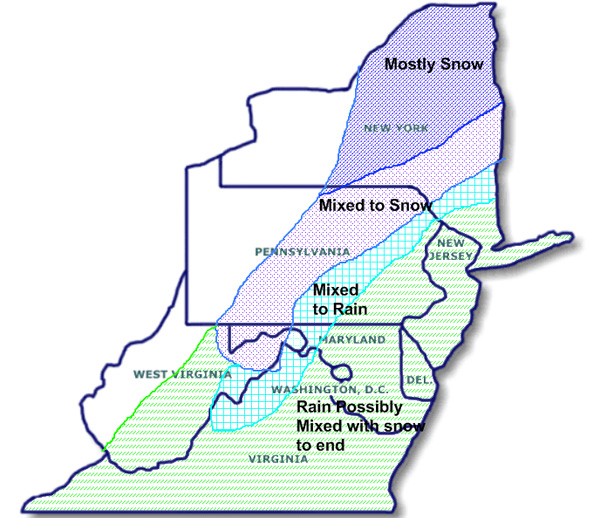
For tomorrow through Friday, the forecast is extremely difficult to pin down. The weather will be dominated by a low that has formed at the tail end of Wednesday’s front that will make its way NE throughout the day. There is a lot of energy associated with this low but unfortunately, it looks like the cold air that is filtering in behind the cold front will not have enough time to cool temps enough for snow to be the dominant precipitation type. As a result, it looks as if mixed precipitation (meaning snow/sleet/rain/freezing rain) will dominate. The big question of course is where frozen precipitation will dominate vs plain rain. The map below should generally explain the forecast, NE will be more frozen than the SE, in the mix to snow area I expect significant icing to occur in some areas with a possible transition to all rain during the day before back to a mix. Mountains in the north (NY, Vermont, etc.) should do well with snow. For closer to DC (not really SE VA even though it is included in the “rain to possible snow” area) it is possible the the precipitation will end as a brief period of snow on Friday morning.
|
|
|
Overall, it seems that this storm will do much more harm than good for all DC ski areas. Seven Springs and Wisp should be the best off as far as ice vs rain, though they could still turn to plain rain. The valley may begin with freezing rain but should change to all rain for a good deal of time, and I would not be surprised if they receive an additional inch or more of rain. Ironically, the highest local area, Snowshoe, will most likely be all rain, approaching two inches by Friday before a little bit of back end snow. Wintergreen should be in the same boat as Snowshoe but may benefit a little more from the backend snow (possibly around 3-5 inches if all goes well). Everywhere else should be almost all rain, 1-2 inches for everywhere.
Snowmaking temps should return to the area Friday night with lows in the 20’s and teens through the areas. Light upslope snow is possible for the valley/Snowshoe/Seven Springs/Wisp as the storm moves out, but little if any accumulations.
For the weekend, things should dry out for once. Areas that did already have a solid base should be open but a little icy. Temps will be in the teens and 20’s at night and high 20’s to around 40 during the day, generally partly cloudy, great skiing weather.
Temps will slowly warm through early next week into the high 30’s to mid 40’s at resorts, still possible snowmaking at night but limited during the day. Another cold front looks like it will move in midweek, with light rain/snow showers ahead of the front. Highs look to be in the low to mid 40’s and lows around 30 for most resorts. After this, it looks like we will alternate between warm and cool with nothing really all that exciting in the foreseeable future.

