Six weeks ago (late Jan 2020) I began what is becoming an annual western winter migration for me. Drove to Denver in two quiet days and skied in Colorado on Jan 28-31. Good conditions with notably light late January crowds. I think it snowed about 5" in parts of the high country the day before I arrived and it snowed about 5" the night before my last ski day. In between was a mix of sun, clouds and some light snow. It got a little busier on my last day in Colorado on Friday Jan 31 at Vail, but I missed any epic mob scenes.
I skied two days at Breckenridge, one day at Keystone, and one day at Vail.
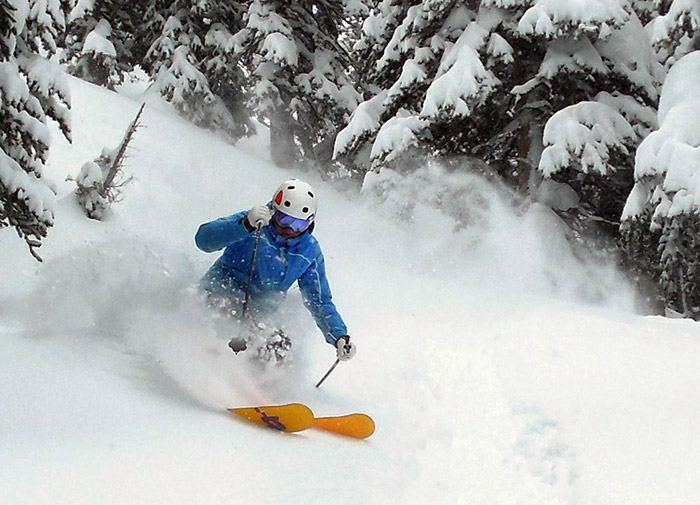
Breck:


I stayed for three nights at an upscale hostel in Breck called The Bivvi for about $80 per night. This included a nice hot breakfast and easy access to a free bus to the slopes. I had respectful room mates and slept well there during my stay.

At Keystone I got in a ton of high speed carving and met a friend who grilled a rib-eye for me while we soaked in the hot tub at the slopeside condo he was staying in. The condos at Keystone are some of the more affordable slopeside lodging in this part of CO.
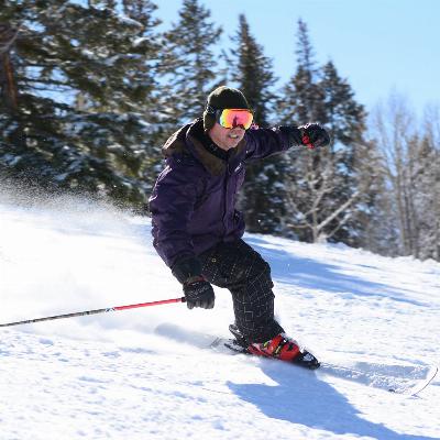
This is summit of dercum mtn. Before the trip I purchased some new skis off steepandcheap for $149 (kastle lx 85) and i like them for frontside skiing, they worked good in a few inches of powder too.

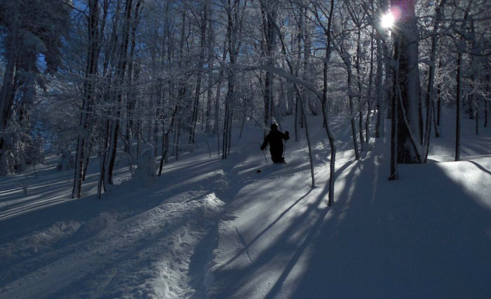
The Outback Chair

Under the lights

Vail, Sun Up Bowl

Champagne Glades in Blue Sky Basin.

BSB again

Then I drove westward. This is a scenic section of I70 near Green River, UT

My wife flew out for $54 to join me and some friends in Las Vegas for Super Bowl Sunday (74 degs).

We tired of Vegas after a few days and continued onto our long term destination in SLC. We went to the International Ski World Cups at Deer Valley Resort under the lights on 2/8/20 and saw the finals of the head to head dual moguls competition. Huge crowd in high octane party mode. Saw some great rippers!! Women's winner Justine Dufour-Lapointe, Men's winner Mikael Kingsbury, both Canadians!


to be continued...
Since arriving at my winter destination in SLC on Feb 5, 2020 I've logged four days at Park City, nine days at Snowbird, two days at Jackson Hole, and one day at Grand Targhee. It hasn't been super snowy in that time, but I have experienced probably four or five powder days in the 6-12" range.
Random shots from recent days at Snowbird:
Middle Cirque

Gelande Hill near Little Cloud lift


Dalton's Draw

Near Bookends area:

Thunder Bowl, far lookers right on frontside of mtn:

A few from Park City, Feb 2020:
This is in the Red Pines Chutes section of 9990.

A friend took this shot of me in the same area of 9990.

Jupiter Bowl:

9990 and Jupiter Peak have some of the most challenging skiing and best snow at PCMR and are rarely crowded.
In late Feb 2020 I went to WY for a few days of skiing at Jackson Hole and one really sweet day at Grand Targhee.
Here some photos from Jackson Hole, late Feb 2020
Upper Hobacks

Rendezvous Bowl

Again, one of my favorite recent photos:

another friend in Rendezvous Bowl, Cody Peak in background.

I like these because Corbets can be seen in background

Long time DCSki friend JohnL

Offpiste in the Apres Vous area.


Grand Targhee, I went here for the first time ever on Friday, Feb 28, 30 degs, super sunny, packed powder conditions, wonderful low-key vibe compared to the mega-resorts, ample free parking 100' from the lodge, light trail traffic. Awesome experience. They tell me I was lucky to catch such clear, stellar conditions because it's often foggy/snowy/low vis. Not for me:-)


I was told that the cliff in the lower center of this photo is where Jamie Pierre set a cliff hucking record of 255' in 2006.


This place gave me a fixation on large tetons

As great as Targhee is on a sunny day, I'm sure I'd lose my mind trying to track up all the open acreage on a powder day with light competition.
Great pics as always!
You were indeed lucky to get good snow and fantastic views at GT. I've managed to catch a powder storm once there with sunshine. It's wonderful! I prefer GT over JH for both vibe and terrain.
Jim you da man .com!
awesome trip, I want to do the drive to Colorado also, this season I am locked into a Killington pass but looking forward next season for some local skiing and I would like to drive out west for couple weeks, I would like to ask you some questions about the drive etc.
about 30 years ago after skiing some of the best powder ever at Grand Targhee my friend who was driving somehow got us on fresh corduroy when we thought we were leaving the parking lot we ended up on a damn slope, we had to get help from a snow cat to get us out
Vermont wrote:
Jim you da man .com!
awesome trip, I want to do the drive to Colorado also, this season I am locked into a Killington pass but looking forward next season for some local skiing and I would like to drive out west for couple weeks, I would like to ask you some questions about the drive etc.
about 30 years ago after skiing some of the best powder ever at Grand Targhee my friend who was driving somehow got us on fresh corduroy when we thought we were leaving the parking lot we ended up on a damn slope, we had to get help from a snow cat to get us out
You need to be in one of these> https://www.roadandtrack.com/motorsports/videos/a27900/formula-1-f1-car-in-snow-ski-slope/
Great pics. Keep em coming
Vermont wrote:
Jim, I would like to ask you some questions about the drive etc.
So I am the madman that drives from Wash DC to the Rockies to ski almost yearly since 2000. Here is why.
I have fun doing it. I will always have great memories of mid-Atlantic skiing. But the mtns are comparatively small. VT can be great skiing if weather permits, but is one full day of driving from me. CO has almost always great ski conditions in midwinter and is just two full days of driving from DC. Over my 50+ years of skiing I've probably done more driving trips to New England, but over the last 20 years more to Rockies to ski.
I have done about ten-twelve drives from DC to CO for a week of skiing (drive two, ski five or six, drive two). I've done about five or six for destinations further than CO, but for longer than one week. I have never driven west to ski for less than a 9 day trip (four driving, five skiing), and usually I've thrown in another day in the middle of the week for a rest day.
Unlike some folks, I love to do cross country drives. All my life my jobs kept me tied to a desk, but I also always had a decent amount of vacation time. The highway represents adventure. The traffic is generally light and I take southerly routes through MD, WV, KY, IL, MO, KS that are rarely messed up by snowy roads. The anticipation keeps me alert through the flat Midwest, the scenery keeps me alert in the Rockies and beyond. The return drive provides time to rest sore muscles, reflect over good times, and think about the next trip. Usually I've had driving partners and take turns driving, making it a breeze. In 1976 I drove solo on my college spring break to CO for the first time. Slept in my car multiple nights. This ski-road stuff is part of my personal ski history.
I am not particularly fond of flying, esp earlier in life. I flew from DC to UT about 8 times in last five years for one-week visits and it was fine, but not without hassles. Many of my DC to Rockies ski road trips have included one or more family members who I would have financed for air fares if we'd flown, this makes ratio of gas costs for driving vs. airfare costs a little closer. Some of these driving trips also happened around holiday times when my kids were out of school, but when air fares are the highest.
I am retired now, so when I drive out I stay for months, not days. I drove solo this Jan from DC to Denver in two days without thinking twice about it. Set me up for four nice ski days in CO, then I continued further west. Will return to DC in a few months. Wife will accompany on return trip, which we may break up by visiting friends along the way.
Having said above, I recognize that for most Easterners it makes complete sense timewise and moneywise to fly for ski trips of 3 to 7 days in duration that involve a destination further away than one day of driving. Caveat: in 2003 I took my family of six for a ten day trip to CO by minivan, there was considerable savings on that trip by driving and not paying for six airfares and one week minivan rental. But the long drive was not too fun with four kids between age 9-18. http://www.dcski.com/articles/281
Probably my most ambitious ski-road trip in recent years was 2018 winter trip from DC to UT to WY to BC to DC, 7000 miles in three weeks. Too much driving, but all went well and included my first ever visits to Revy and Banff areas and was a very memorable trip.
PS: I have rose colored glasses for anything to do with skiing and that has also impacted my willingness to endure long drives. Also, DCSki member Denis has been an inspiration for some of my big drives as he's done a lot of them too, including several solo.
I'd like to add some thoughts for all adventure skiers, simply put, get out and do it now. I did and am rewarded to see that Jim is doing it now. None of us knows how long we have, by that I mean years when we will enjoy adventure skiing. We are all aging and those years can be taken or compromised. I am now in the process of losing part or all of 3 of the last four seasons to injury. First came the right shoulder rotator cuff, the major tendon completely ruptured, 3 more partially torn, next, 2 total knee replacements, now a groin injury suffered 6 weeks ago that seems to be not healing at all; I can barely walk, let alone ski. I'll recover from this one too, but the need for recoveries is becoming more frequent and they take longer. The mental resolve to do serious adventure descents is pretty much gone too. I still love powder and would hate to become a corduroy only skier.
I retired 11 years ago while still living in NoVA and went for it. In the first years I'd get an eastern pass at Stowe or mad River and a western pass. That would mean 2 each 3-5 week road trips. It was great and I just couldn't get enough skiing. For several years I had my western pass at Alta. Then I decided that there are too many "powder locusts" in Utah (John L's term) and went to Montana focusing on less known places with cheap prices, no crowds and uncut powder that lasts for days. That was in many ways the best road trip. After that, when my wife decided to retire and we were pretty committed to CA, it became the Sierra and Kirkwood where competition for powder on weekdays is very light. I did a little bit of solo backcountry in Carson pass but it is bigger and scarier than WV. From now on it's going to be pretty much sidecountry reached from lifts, and hidden, low angle, powder stashes the the big boys and girls neglect.
This story is too long already. The bottom line is, go out there and get it. And post the stories for me and my cohort.
Of course caution in traveling must be considered until we have at least gotten past the acceleration phase of this virus. By saying, go get it now I do not mean the immediate now.
Awesome info, stories and pictures! really makes me want to road trip it next season to Colorado and beyond, it's been a long time....
Denis, I appreciated your post -- thank you for writing that. I hope your recovery time hastens.
Denis might be same species as Yoda. He is wise and still a youngster in yoda-years.

I love the ski adventure stories and pictures. I made a few trips west several years ago while my son was stationed at Ft. Carson. I enjoyed driving and seeing the country beyond the east coast. I'm retiring in June after 32 years with the post office and plan to make a lot road trips! I'm thinking about getting the Ikon pass and hope to ski at as much as possible. No more not being able to follow the snow or take a snow day locally because I have to go to work!
JimK wrote:
Denis might be same species as Yoda. He is wise and still a youngster in yoda-years.
Ah - but in Nevada ....

Encouraging news today. Snowbird plans to continue ski operations through the spring. Good thing, because I want to ski out here until May!
Brighton 12 March 20:

Solitude 13 Mar 20:

Wow, what a difference a couple days make. As most of you know, almost all of North American skiing has shut down, at least for the next week, and many places for good. Here in Utah it appears that the only larger resorts that are still open as of 3/15/20 are Powder Mtn, Sundance, and Beaver Mtn. All three of those are smaller "mom and pop" type places for which I don't have a pass, but if all the others stay closed and they remain open, I may get more familiar with them over the next couple of months.
We shall see what the future brings. I hope all of you remain safe and healthy, this is one of the weirder national emergencies I've experienced in my 66 years. After googling national and state parks it looks like those are still open. My plan B may be to take my wife on a scenic road trip to various parks out here for a few days?
JimK wrote:
Wow, what a difference a couple days make. As most of you know, almost all of North American skiing has shut down, at least for the next week, and many places for good. Here in Utah it appears that the only larger resorts that are still open as of 3/15/20 are Powder Mtn, Sundance, and Beaver Mtn. All three of those are smaller "mom and pop" type places for which I don't have a pass, but if all the others stay closed and they remain open, I may get more familiar with them over the next couple of months.
We shall see what the future brings. I hope all of you remain safe and healthy, this is one of the weirder national emergencies I've experienced in my 66 years. After googling national and state parks it looks like those are still open. My plan B may be to take my wife on a scenic road trip to various parks out here for a few days?
Hasn't been a pandemic of this scale since 1918 when millions died worldwide. The last flu epidemic that resulted in over 500,000 deaths was in the 1970s. We are in unknown territory with the connections via planes and the Internet in 2020. Close to 3000 have already died outside China. Asian countries that beat back SARS are stablizing while Europe and other continents are just getting organized.
https://www.flattenthecurve.com
Take care!
Crazy times indeed. We are late-season skiers, and we had two trips to Snowshoe and one to Big Sky cancelled. I'm glad that we are all healthy right now, but I can't help but be a little disappointed.
Jim, I'm curious about what multi-resort passes and what individual lift tickets you bought. It looks like those resorts are a fun combination of Epic, Ikon and somewhat independent.
I have a senior season pass to Snowbird and an EpicPass. My Snowbird pass entitles me to half price tickets at all the Mtn Collective resorts including Jackson Hole. I used Liftopia for my visit to Grand Targhee.
With all that, I think I am going to go snowshoeing today:-)
JimK wrote:
(snip)
With all that, I think I am going to go snowshoeing today:-)
Snowshoeing sounds like a good choice, JimK! Enjoy and be safe.
Woody
bousquet19 wrote:
JimK wrote:
(snip)
With all that, I think I am going to go snowshoeing today:-)
Snowshoeing sounds like a good choice, JimK! Enjoy and be safe.
Woody
Woody, hope you and all the other DCSkiers stay safe too!
Yesterday my wife and I did get out and snowshoed up in Big Cottonwood Canyon. It was fairly quiet, but we did see a sprinkling of skiers going into the backcountry with skins.

practicing social distancing

Solitude Ski Resort was very quiet

THEN this morning we were woken at 710AM by a 5.7 earthquake here in SLC. It caused no damage to the neighborhood, but was a darn good 10 second shake and rumble with numerous smaller aftershocks. I was in Charlottesville, VA for the earthquake in 2011 and this was pretty similar. Checking further reports there was some minor damage to buildings in downtown SLC including the famous Mormon Temple where the Angel Moroni statue lost its trumpet. That news gave us a chuckle and we're not sure what kind of SIGN that is, but we don't need quakes on top of the virus. 
If you are looking for an outdoor day trip, I highly recommend American Fork Canyon a few miles south of little cottonwood. It's the most beautiful of the Wasatch canyons IMHO. Backcountry skiers use it for access to Timpanogos. There is a pretty little lake with good trout fishing.
antelope island to see the buffalo herd is another good day trip.
Denis wrote:
If you are looking for an outdoor day trip, I highly recommend American Fork Canyon a few miles south of little cottonwood. It's the most beautiful of the Wasatch canyons IMHO. Backcountry skiers use it for access to Timpanogos. There is a pretty little lake with good trout fishing.
antelope island to see the buffalo herd is another good day trip.


Upbeat article about Utah hiking during the virus crisis: https://www.sltrib.com/news/2020/03/21/i-feel-like-hiking-is/
22 Mar 2020 my wife and I intended to visit Antelope Island State Park. It's about 50 mins northwest of SLC and is the largest island in the Great Salt Lake. Lots of great wildlife on view there as Denis mentioned. But when we got about 5 miles from the island there was a big traffic jam. Tons of people had the same idea. It was a beautiful day for a drive, so we turned around and went to Great Salt Lake State Park. It's about 15 miles west of SLC off I80. It was much less crowded and we had fun walking along the shoreline of the lake.

Good place to practice some social distancing:

BTW, Antelope Island is in the background between us in this photo:

Hopefully these posts provide a little diversion during this difficult time.

29 March 2020, Neighborhood stroll around Cottonwood Heights. At this time of spring in the Salt Lake Valley many days reach high temps between 55-60 and it is quite nice for walking and yard work. Because we are so close to the Wasatch Mountains, however, there is still a natural snow machine in effect and about once a week we will wake up to a inch or two of snow in the yard, only to watch it melt by mid-day. The higher elevations in the mountains get much more.
The abandoned Old Mill. A paper mill was first built here in 1883 and partially rebuilt in 1927.

Nearby Old Mill Park. The entrance to Big Cottonwood Canyon is in the left-center background.

View of same area from near the mouth of BCC. The old mill is the orange building to right. Downtown SLC is in far background.

More soon...
3/30/20
Bonneville Shoreline Trail near Holladay, UT:
Pretty trail, involves a ~400 vertical foot climb, then the trail follows the contour of the front range of the Wasatch and is relatively level and easy hiking with great views of the Salt Lake Valley.


3/31/20 Golden Spike National Historical Park, UT:
Promontory Summit where the first transcontinental railroad connection was made (and golden spike driven) is a somewhat desolate high ground near the north shore of the Great Salt Lake.

The beautiful Chinese Arch named after railroad workers.

One of numerous rail bed cuts dating back to 1869.

The Big Fill was an extremely laborious engineering project necessary to build the rail bed over a ravine not far east from the Golden Spike site. This was a big deal in 1869 and took months for 500 men to fill. It made me think of almost any drive through the state of West Virginia, where there are far larger fills every mile or so :-)

FYI, we made no stops driving to and from Golden Spike National Historical Park and our only time outside our car was for quiet hikes along the abandoned rail line. Our smart phones allowed us to get a nice audio tour while visiting the park.

2 APR 20: Like probably all of you are doing as the virus crisis deepens, we are adapting to stay at home orders here in Utah. Fortunately, 15 minutes from home is a good place to go skinning. My son the veteran skinner took me the rookie for a bit of skinning action this day in Little Cottonwood Canyon at Alta, UT.
I've done downhill skiing for over 50 years and dabbled in cross-country skiing and snowshoeing for almost as long. But this was my first day of skinning in alpine touring equipment. I used my own downhill boots and an extra pair of downhill skis (Volkl Ones, 186cms length, 116mm width) with AT bindings that my son loaned me. He set me up with a pretty heavy rig, but we only did two climbs at Alta; 1) to the top of the Albion Double Chair liftline 867' vertical, and 2) a shorter, but steeper climb ~350-400' vertical from the Wildcat Base to Lower Rustler.
It was a beautiful day on the mountain with blue skies and about 4-5" of new overnight snow. It was 27 degs when we started at 1030AM, but felt like 47 with bright sun and no wind down near the base area. There might have been a hundred cars in the Albion lot, but people were very dispersed and trail traffic was light. For our climb up the Albion liftline I saw about three skiers, two snowshoers, one hiker, and two tobogganers.
The veteran and the rookie.
This is what it's all about! And good motivation during our first climb.
The veteran displays his climbing technique (note avi pack).
Devil's Castle is still there. What a beautiful day!
Albion liftline skiing.
View from Wildcat Base. We climbed up the intermediate run to right a short way and then caught lower Rustler to left.
This photo gives a sense of the number of cars in the parking lot beside the Goldminer's Daughter Lodge at about 1PM.
Traversing over to Lower Rustler.
Mission accomplished.
It was sad driving by a very lonely looking Snowbird resort.
My conclusion about skinning is that it's a whole lot of shuffling for relatively little schussing. But skiing is skiing and it felt good to get out there 20 days after my last lift served day
Bonus shot my son took of me, a lot of calories were burned to get in position for this photo:-)

This was a very mild and safe intro to skinning as all climbs were made on a packed surface and the runs did not stray far from the same. True backcountry skinning requires knowledge of snow conditions, specific avi gear, experienced partners, and good planning to ensure your safety.
Quite surprised to see that Alta was still grooming some of the trails!!
Yes, I suppose it is to facilitate access to their lifts and restaurants for off-season repairs or other activities. But it also has the side benefit of making uphill travel easier for newbie skinners like me. Only a few runs are packed/groomed. Here is their uphill policy at this time:
Alta Ski Area will allow uphill access within the ski area starting March 20th. Backcountry Conditions Exist. No access to Snowbird.
Please treat the ski area as backcountry terrain. Carry and know how to use avalanche gear. There is no ski patrol. You are responsible for your own rescue.
Restrooms in the Skiers Services building at the Wildcat Base and Albion Ticket Office at the Albion Base will be open for public use. These restrooms will be cleaned regularly between the hours of 8am-5pm.
Please note that the State of Utah issued a Public Heath Order and the Town of Alta has issued an Emergency Proclamation prohibiting gatherings of 10 or more people. We encourage all visitors to the ski area to abide by the Emergency Proclamation and not gather in groups of 10 or more people in the parking lots and ski area.
Looks beautiful. Thanks. Wish I were there with you.
Thanks for the pictures. It really lifted my spirits here back east as Kath and I rarely go outside. The rail trail behind our house is very crowded as is a nearby bird sanctuary but we found a spot that has remained crowd free so we hike there are often as weather allows. Nice turns.
I'm also enjoying these posts and really want to visit Utah some day now.
wfyurasko wrote:
I'm also enjoying these posts and really want to visit Utah some day now.
It is interesting to hang out with Utah locals. They often talk about the "good old days" 20-40 years ago when the ski resorts were much less busy. I skied Utah only once back then for a week in the late 80s and don't have much to compare against my more frequent visits in the last 5-10 years. I guess the big change is powder days. All days now where there is more than about 6" new overnight snow, and especially more than 12", are crazy busy with traffic jams and 10 minute or longer lift lines at most ski areas near SLC. It doesn't matter if it's a weekday.
The local population, ~1.5 million in greater SLC, has grown over the years including many migrants who like to ski. IKON has had a big impact too, bringing more locals (cheaper than a single resort season pass) and tourists onto the slopes. Some of my favorite days out here are sunny spring days - no crowds, empty slopes and still very good snow conditions. That's made this spring's closures tough, but we have to beat this covid thing.
I think that air fares have become more affordable than ever in relative terms compared to average income, making frequent flying possible for many folks. This combined with the close proximity (45-60 mins) of many Utah ski areas to the SLC airport is another factor changing the feel of Utah skiing and increasing traffic. The airport here is located in the nearby desert and very rarely impacted by weather/snow. If there are flight delays it's usually due to problems somewhere else in the USA.
Despite this, Utah's still a neat place for a skier and mountain lover, especially for a relative newcomer like me, where everything is still new and exciting. Of course, I like all mountain areas East or West. It's all good:-) My son's residence out here is what has me focusing on Utah these days.
Snowbird January 2017:
How does "crowded" out west compare with crowded back east? My brother got spoiled for a few years when he'd visit his wife's family in Colorado. When he skied with me at Camelback, all he could talk about was how crowded and "icy" it was.
To be honest, nothing I encounter these days, East or West, is as crowded as places used to be back in the 1970s. I can remember one hour lift lines on many prime weekends at Blue Knob. I find that many of the larger western resorts are big enough to find remote areas/lifts (usually high or wide) from the main bases where you can escape crowds even on busy days. To some extent you can do the same at mid-Atlantic resorts, such as Main Street chair at Wisp or the quad chair serving Paradice trail at Massanutten. However, if you tangle with key chairlifts at Vail, Snowbird, Breckenridge, etc. on big days, you can see crowds just as bad or worse as big days on the front side of Liberty, Camelback, or the HSQ at Whitetail. Local knowledge about a ski area can help a lot with crowd avoidance. Also, common sense goes a long way too, like avoiding holidays. AND a good ski day is a good ski day wherever.
Timberline, WV, January 2016
Went snowshoeing today up in Big Cottonwood. Still lots of snow once you get up near Donut Hole Falls area. Solitude and Brighton still look pristine. The snow was pretty crusty starting out but had softened up near the parking lot upon return. Would post pictures, but I'm not quite sure how to do that on this forum.
As to the crowded argument of longtime locals: It is more crowded on powder days especially at major areas like PCMR, Alta and Snowbird. That being said you can still find good snow at those resorts if you're willing to go off the beaten patha bit. Sometimes this means a traverse, short hike or dipping into the trees. The BCC resorts will have good lines at open but generally thin out fairly quickly. The one exception is Honeycomb Canyon at Solitude. If patrol can't get that thing open by 10 a good crowd will form and make the traverse feel like the skiing equivaliet of the Beltway at rush hour once the ropes drop. I really wish more snowboarders would start to carry trekking poles on their back for use on traverses. It would make their days more enjoyable and keep them from popping off their boards and trying to walk on the traverse. TAKE THE SKI BUS.
Lastly, you can avoid the crowds and hit Powder Mountain. Much more of throwback area with a handful of lifts serving huge acreage with zero snowmaking. You can find great snow there days after a storm (just check the snow report as it's storm-track is different than the Cottonwoods).
Good post Uinta Terp. Good to hear from another with a DMV connection out here.
Some photos from my April activities in Utah:
Walking around the neighborhood 7APR20.
It's not just Major League Baseball that's been shut down. All youth baseball across America is also impacted. In spring this is normally a busy ball field in the Salt Lake City suburbs.

God bless America. Stay strong! Things are gonna get better soon. Maybe one of the silver linings in this cloud is that we all learn to be nicer to each other in the future.

A few days later my wife and I took a walk on the Quail Hollow Trail. It's near the mouth of Little Cottonwood Canyon.

4/22/20 A father and son shooting hoops.

4/23/20, I dusted off my son's mountain bike and took a one hour ride around the area today. It was fun and I'm interested in more biking to expand the range of exploration beyond my walks.

I usually ride a hybrid at my home back East, so this fancy mtn bike took a little getting used to. I stuck pretty much to asphalt/paved surfaces today, but I might try some dirt trails as time goes on. This is a photo from a very upscale housing development above the gravel pit at the mouth of Big Cottonwood Canyon.

This project (Tavaci) was zoned for large single family homes, but I think the developer also has grander plans calling for a resort and commercial stuff. This spectacular structure looked too big to be a residence. I'm not sure if it currently serves as a sales office or maybe it's supposed to become some kind of community center?

4/25/20 I took a two hour bike ride today down to the Jordan River Parkway Trail.
This is the mighty Jordan River near Midvale, UT. It starts at Utah Lake near Provo and flows north through the Salt Lake Valley to the Great Salt Lake. Four of Utah's six largest cities border the river: Salt Lake City, West Valley City, West Jordan and Sandy. More that a million people live in the Jordan River watershed.

There is a nice network of paved trails in this area. The Jordan River Parkway is a north-south system of trails that parallel the Jordan River, connecting 45 miles through Salt Lake County. The trail further connects to neighboring counties, allowing for travel to Utah Lake and the Great Salt Lake.

Weather for the next week here in the SLC area will be sunny with highs between 75 and 85 degs F. Hope the heat kills a few virus bugs!?!

Nice. Another good one is the Ogden River Parkway Trail.
4/28/20: I went back to the Jordan River Parkway Trail today and took about an 80 minute bike ride exclusively on the trail from West Jordan to Draper, UT and back. The trail has numerous connectors and you can vary the return route so it's not a complete repeat, but somewhat of a loop on either side of the river. The sun was out and the temps were in the upper 60's this morning and not too many people.
I passed by three different golf courses on this ride. This one is River Oaks and was pretty near where I started my ride. There were golfers on each course, but not very many.

This is the Jordan River looking south. It flows from south to north into the Great Salt Lake where there is no outlet.

This is River Bend Golf Course and is where I turned around and headed back north to my starting point. This course had some great views to the east and west. I am a golfer and have not golfed yet in Utah, but besides borrowing my son's bike I might also borrow his clubs soon:-)
West view.

East view.

This shot is for Johnfmh.

That's the entrance to Little Cottonwood Canyon as seen from the South Jordan area. No wonder they have to do so much avalanche mitigation to keep the road open in winter - it's a steep walled sucker.

Jim, Thirty some years ago I golfed a beautiful course in Park City. Remember that at PC's altitude the ball travels farther than at SLC. It also means that slices move farther to the right off the fairway!!
MorganB aka The Colonel
Beautiful. Cycled around your N VA neighborhood a few days ago. Great cycling witth most cars off the roads. The new bicycle/ped bridge at the intersection of 29 and 237 is coming along nicely.
It was 85 degs in the Salt Lake Valley on 4/29/20 and we hiked around Dimple Dell County Park near Granite, UT:


Also warm on 4/30: Purple mountains majesty!
Today, 1 May 2020: It was about 63 degs in the valley and my son and I went up to Alta this afternoon to do some skinning. We only climbed about 1000 vertical feet from the Albion Base, past Alf's Restaurant, and partially up the lower part of the Supreme lift. Good exercise going up. Coming down was pretty much green circle terrain. We only made one climb and run. Cloudy day, about 48 degs. Still plenty of snow. The whole inbounds area would be skiable if lifts were still running.

My son is pointing out the Sugarloaf lift in the far center.

Approaching Alf's Restaurant, mid-mountain.

This photo is for IMP from Laurel Mountain, PA!
We stopped climbing at the small cluster of private homes about one-quarter way up the Supreme lift line.

A sign on this vehicle said it needed a new clutch and would be fixed ASAP, but it had nice seat covers

Heading back down we passed an area of downed trees near the base of the Supreme Lift.

This is my son on one of the few steeper pitches we skied. This might be my last ski day of the season (day 28), not sure. The snow should remain skiable for another month or more at Alta for those who want to earn some turns.

I may have missed this but did you move to SLC. Great stuff!
jn_freedman wrote:
I may have missed this but did you move to SLC. Great stuff!
No, just went out for the winter to ski and more. Will return East when covid situation eases.
3 May 2020: No home improvement work today, all fun.
Took bike ride in AM around Hidden Valley Park in Sandy City, UT. This was 90 minutes of mixed trails from wide asphalt, to narrow dirt, to everything in between. They relaxed the stay at home order here on May 1 and you can now recreate beyond your own county. In the PM I took about a 100 mile scenic car ride with my wife to Provo Canyon.
A lot of plants are blooming. Temps were again above 70 degs today. Hidden Valley Park:

Closer to the Hidden Valley watershed.

I took a walk over this nearby bridge to take a peek at this segment of the Bonneville Shoreline Trail.

Back on the bike near Hidden Valley Park.

The trail eventually widened and was better suited to my low skill level.

I eventually went into the Sandy City suburbs on my return trip. I had ridden along that contour trail on the lower portion of the mountainside in this photo.

Later today I took a drive to beautiful Provo Canyon and US Route 189.

I knew that Bridal Veil Falls was along this route, but I didn't know how super close it was to the highway. What a treat! This is the biggest waterfall I've seen in many years.


A beautiful section of the Provo River not far from the falls.

We made a two mile side trip to Sundance Ski Area. Very cool, I had never been there before. It's in a narrow canyon off US 189. That's a chairlift to the left in this photo.

A view of Mt. Timpanogos from Sundance Resort.

Thinking that Jim could use some help keeping the forum going during this slack time, so here are a few reflections on skiing the Wasatch.
The dream of every Wasatch skier is to be at the mountain when inter lodge travel is restricted by avalanche danger. Being caught outside at these times will incur a $1000 fine. The road up from the valley will be closed. The Little Cottonwood Canyon road to snowbird and Alta is the most avalanche prone in America with dozens of known slide paths that cross the road. It follows the old horse trail used to reach the mining camps a century ago; building a road there would never be approved today. When the danger has moderated (it never goes to zero while there is still snow) it takes time for plows to clear the road and more time for the stampede of skiers to reach the resorts. The few hundred lottery winners who are already there get a half day or more of powder paradise with virtually no competition. I used to stay at a cheap motel in Midvale and take the bus daily. A season pass at a resort gets you free passage on the bus. One day at Alta it began to snow 2-3" per hour and skiing was fantastic. I played a hunch that interlodge would be declared and got a bunk room for the night at the Snowpine lodge even though I had a paid room in the valley. It played out as expected so I got endless powder the next day.
If riding the bus from the valley when the roads open after a big dump, a smart move is to take the bus to Big Cottonwood Canyon and ski Solitude or Brighton. Buses to Little Cottonwood are often filled at the first stop and the drivers will not accept any passengers at subsequent stops. Even if they do, the backups often extend all the way down to "the benches" in the valley. There will be more buses, fewer passengers, and shorter backups going to Big Cottonwood.
Riding the bus on most days I became acquainted with a big guy with an Austrian accent, the very image of a mountain man, and we would talk. He had lived there for years and had great mountain wisdom as well as local knowledge. He told me to watch for a warm wind from the south for 2 days; it meant that a big dump was coming . It made instant sense. Storms in the northern hemisphere have counterclockwise circulation and if coming straight from the west, winds on the advance edge will be from the south. 2 days of south wind meant a big one. He was also an avid summer hiker. He told of rounding a corner on a rock walled trail and surprising a big mountain lion resting in the sun. They looked at each other for a moment and could read each other's intentions, "leave me alone and I'll leave you alone". That guy was a loner and I never skied with him. Didn't seem appropriate to ask and he never asked me.
Thanks Denis
Thanks Denis
Denis, they had an exceptional interlodge situation in Little Cottonwood Canyon this winter. It was caused by a 15" storm on Feb 5/6 that was not especially deep, but very wet snow and it closed the access road and halted all lifts at Alta/Bird for two and a half days: Feb 6, 7 and until 11AM on the 8th! I've never heard of a closure for avalanche mitigation for that many days in LCC, but I don't have a long history in Utah. That was one interlodge situation you didn't want to get caught in because you couldn't ski and you couldn't leave to go down to the valley or to the airport.
More bike riding photos:
6 May 2020, took another ride on the Jordan River Trail from mile 17 (Draper) south to mile 10 (Bluffdale) and back. This is an area that transitions from suburban to rural during the course of the ride to Bluffdale. Bluffdale is about 25 miles south of downtown Salt Lake City.
This is around mile 16 on the JRT and not far from where I started riding. The view is to the west at the Oquirrh Mountains. Oquirrh is a Shoshone Indian word for "wood sitting".

Nearby farm country. A portion of the old Kennecott Copper Mine can be seen in the background. It's the largest manmade excavation in the world.

Baby lambs beside the Jordan River Trail.

I'm not LDS, but I admire some aspects of this religious group. They have an amazing network of churches here in Utah, usually one per mile, no exaggeration. In this photo taken near Bluffdale, UT you can see three LDS church steeples, left, center, and far right.

UTA light rail extends more than 20 miles south of downtown SLC. The Jordan River basin is a little more significant here than up north.

As pretty as Utah is, the land has not gone unscarred by development. Gravel pits and past or present mining operations dot the mountainsides every few miles. I suppose these facilities fuel progress and supply many jobs, but they're not so pretty.

The sign marks the Galena/Soónkahni Preserve, Draper, UT. At 250 acres, it's the largest Jordan River preserve in Salt Lake County. The site features the Jordan River with meanders, sand bars, and oxbows, riparian and wetland habitat, and drier upland habitat. The property includes an archaeological site with dwellings and artifacts ranking among the oldest known in Utah. Native Americans including the Shoshone frequented this area in the past.

Jim K>. As pretty as Utah is, the land has not gone unscarred by development. Gravel pits and past or present mining operations dot the mountainsides every few miles. I suppose these facilities fuel progress and supply many jobs, but they’re not so pretty.
A lot of silver was taken out of LCC. It was the Wild West; about 300 men died in gunfights and another 300 in avalanches. The mountainsides were stripped of trees to support mineshafts. Pictures in various lodges taken in the late 1930s show far fewer trees than today. One day I decided to skin up into Grizzly Gulch, starting from the very end of the road just past the Albion base. The snow was overcooked, heavy and wet, so I didn't go far before skiing down. The next day I mentioned it in a chairlift conversation and was told, "you're a lucky man, there are uncovered mine holes up there." There was a plan to do cat skiing up there, so the mine holes have probably been filled. The Wasatch is so popular with backcountry skiers that I suspect there are few holes remaining today. The Oqirrh range to the west of Salt Lake City is a different story. https://en.wikipedia.org/wiki/Oquirrh_Mountains they are treeless and look like ideal ski slopes from a distance, but nobody goes there because of mine holes.
Hi Dennis - 100% correct. When we lived in Park City basically the issue was and still is mine tailings in the local water supply. That is why we never, ever drank tap water; beauty and the beast?
E-
5/9/20, I continued my exploration of the Jordan River Trail (JRT) today. I rode 15 miles from mile 11 to about mile 3.5 and back again. This is a very beautiful section of the JRT about 30 miles south of downtown Salt Lake City and about 15 miles north of Provo, UT.
This is a view looking to the east of Thanksgiving Point Golf Club near Lehi, UT. The JRT crosses that bridge in center and goes to the right (south).

There is still snow in the mountains all around the Salt Lake Valley. This is the view to the west. It was another beautiful 70-75 degree day in the area.

On May 7 Salt Lake County, UT moved to "Moderate Risk" with respect to public health orders. For retired recreationalists like my wife and I that meant we were free to venture farther from home for sightseeing and such, while still practicing the 6' social distancing rule. At the same time many state and national parks in Utah are reopening.
So yesterday, 13 May 2020, we decided to take a very scenic, but long day-trip to Goblin Valley State Park. As the crow flies, it's about 50 miles west of Moab in southeastern Utah. The roundtrip for us was over 400 miles! But it was a low stress and very rural route and the weather was great with a mix of sun and clouds. The highest temps we experienced were in the state park where it was about 80 degrees. Driving over Soldier Summit (elev 7477') it was in the high 50's.
From our location near SLC this trip was a lot of driving, but when we got there I just about lost my mind with photo opportunities. This place was one of the weirder geological oddities I've ever seen with thousands of sandstone goblins or hoodoos ranging from 5' to 500' in height. It felt like you were in the middle of a giant sand castle that was going through a slow motion act of creation and erosion all at once. It seemed so crazy-fragile, like only compacted dust was holding up giant, round sandstone boulders weighing thousands of pounds. I couldn't believe we tourists were allowed to scramble all over every inch of the place. Parts of it would crumble underfoot or turn to dust when you scratched it with your fingernail. This was the place where some boy scouts got into trouble back in 2014 for pushing one of the formations over: https://www.nbcnews.com/news/us-news/ex-scouts-leaders-who-knocked-over-ancient-rock-get-probation-n56596
I can imagine that someday they will have to manage visitors and keep folks to designated paths through this park, but for now it's the wild west.
Sorry for the humongous photo blast, but I can't help posting a couple dozen pictures of one of the most geologically photogenic places I've ever been. Goblin Valley State Park, UT is wild!
Prelude:
Driving from SLC to Goblin Valley SP includes about a 125 mile stretch of US 6 from Provo to Green River, UT. This is desolate, but wide open country that I find relaxing to drive.
This is a train near Soldier Summit, notice the greenish dirt in the left hillside? Does it have copper in it?

US 6 cuts through Price Canyon east of Provo.

The big rock in upper center is called Balance Rock. This is on the outskirts of Helper, UT.

Entering Goblin Valley State Park. By this point the weather turned beautiful.

The first mind-blowing sight in the park is The Three Sisters formation. I guess these are about 100' tall.

Another angle.

This is a view of Goblin Valley from the observation point parking lot. There is a couple square mile area to explore here. Many of those "goblins" are the size of a large house.

Looking north from the middle of the valley.

It's a wild place to take a stroll and you probably wouldn't want to be here in the middle of the summer - too hot and dry.

Three baby sisters?

Precariously perched rock. This place seemed so fragile, like you could topple that rock with a couple karate chops to the belt.

This looked like some sort of time portal...

and reminded me of an old Star Trek episode.

This girl was super excited. It was like the world's largest playground/sandbox.

This cave piqued my curiosity.

View from the inside.

My wife was also captivated by Goblin Valley State Park.

Obligatory shameless tourist photo.

There were about 40 other people exploring the valley with us. Social distancing was easy. We brought our own food and only stopped once for gas on the trip.


The land of giant mushrooms.

This is in another part of the park near a campground. I called this no-see-ums hill because some kind of insect bit me three times here. It felt like a mild bee sting, but I couldn't see what did it.

These yurts are normally rentable for overnight stays, but they were not available due to covid.

This is a panorama shot of part of Goblin Valley. Very cool place.

Not sure if this video will work: https://photos.google.com/photo/AF1QipMJt9EH3Kwk6qT2k3sQBm5Uq5HZ_0VPGYZe4VkB
Wow Jim, I'm extremely jealous! Those photos are beautiful. Looks like you had a fantastic time and definitely no issues with the social distancing. :)
A couple photos from recent days:
Sunset over Salt Lake Valley

Three tractors in Granite, UT

17 May 2020, Had an unusual double activity today, first time to do biking and snowshoeing on the same day.
Went bike riding on the Jordan River Trail in the AM from about mile 25 to 30 and back. This was mostly through the town of Murray, UT. Lots of tight turns in the trail with many Sunday strollers and a suburban/urban feel. Not so great for riding, but still interesting. I took it slow on the mountain bike.
Scenic pond beside the trail in Murray. It's so weird to still see plenty of snow in the Wasatch, while it's been over 70 degrees in the valley almost every day for the last month or more.

Amphitheatre

Family of geese, there were three chicks hiding in the grass.

Believe this is a cormorant bird, stays under the water for 10-20 secs at a time looking for food. It's a medium large black bird.

It's been very warm and dry for over a month here. This was a fresh, but small brush fire beside the trail.

Then around 4PM my wife and I went snowshoeing up at Guardsman Pass near Brighton ski area in Big Cottonwood Canyon. Temps went from 82 in the valley to 64 degs up on the pass. The road over Guardsman Pass to Park City was still closed and when we came to the closure gate at about 9000' there was a good 2-3' of snow on the road. It was a good place to snowshoe...in shorts

Representing Washington DC sports teams.

This is a panoramic photo of the upper part of BCC. Brighton ski area is to the left, Solitude is to the right. Lots of snow cover still.

Photos from late May 2020, Salt Lake Valley.
The Wasatch Front got three or four inches of new snow on 23May20. Meanwhile down in the valley it broke 90 degrees much of the week.

I've been working a lot around my son's house in SLC making a retaining wall and some related improvements. But 27 May 2020 I took time off to play some golf at nearby Old Mill Golf Course. Nice public course in the foothills with great views and a lot of vertical change in some of the holes. This was the first time I played golf in Utah.
Naturally I borrowed my son's clubs. Some time I have to make a dedicated post about all the toys I've borrowed from him this winter/spring:-) Downtown SLC is in the far right background to the north.

First hole, looking west:

On 5/30/20 I did something that was memorably touristy. I went swimming in the Great Salt Lake. This is not something local Utahns normally do. The Great Salt Lake is a terminal lake, approximately 75 miles long and 25 miles wide. Streams and rivers flow into it, but nothing leaves except through evaporation and that makes it five times saltier than the ocean. It's a good habitat for birds, bugs, brine shrimp, and sail-boaters, but not much else. Parts of the lake smell like a salt marsh on a bad day:-) You might say it's best enjoyed from a distance. Nonetheless, it was 92 degrees out and I was looking for a new way to get cool.
I accessed the lake from a location off I80 about 15 miles west of SLC. I had to walk about 1/2 mile across the beach to get to the lake shore, where this photo was taken looking back at the place I parked.

Just as I approached the water a wind/rain storm blew over. It was pretty ferocious and scared all the other crazy tourists off the beach. I had to hunker down and lay on the ground during the worst 10 minutes to evade stinging sand and very low visibility. It was mostly a wind event, but the brief period of moderate rain felt good after many dry and warm weeks here in the Salt Lake Valley.

The sun came back out and I set up my camp chair in 6" of water. I did enter the water and went swimming two times. At the end of the day my hat, shirt and swim suit felt like tin foil they were so crunchy with dried salt.

This fellow was determined to try to get a good photograph of that sailboat. He's standing in about 2' of water even though he's 300 yards offshore! I think the deepest this huge body of water ever gets is about 15'.

The water felt like about 80 degs very close to shore. A couple hundred yards out it got colder, maybe 72 degs. Also, it got clearer and rather nice for wading the further out you went.
Next subject; this is a sunset photo of the Salt Lake Valley from a couple nights ago.

A little later on the same evening, the Great Salt Lake can be seen along the horizon.

29 May 2020, this is my wife's idea of a good place to get cooled off. That's Big Cottonwood Canyon Creek.

This is an Episcopal chapel at a camp near Brighton ski area.

We were hiking there on 5/31/20 to beat the heat down in the valley, 73 degrees at 8000', 89 degrees at 5000'.

This "cowboy" was taking a chance walking this close to wild moose for a photo op along the Big Cottonwood access road.

Jim,
1. I love your stories about adventures in Utah/Salt Lake City, in all seasons!!
2. My daughter is a pediatric children's physical therapist and worked at the SLC Children's Hospital for a few years. Like you, we visited often. It definitely is a unique part of the US.
3. I might suggest you delay coming back east until things calm down a bit, and until we learn if the mass marches, etc. have set off another wave of COVID-19.
Take care and keep posting!
MorganB
ps: who was the cowboy you encountered!
... ah yes I remember it well. Good stuff!
E-
Here are about 20 photos from Utah during the first half of June 2020. These illustrate a great diversity of terrain and activities available in early summer in Utah. Some of these photos are panoramic shots and may enlarge if you click on them.
Below are two photos from a favorite nearby county park called Dimple Dell. I like to bike and hike here and it's usually very lightly trafficked. It's a couple miles west of the mouth of Little Cottonwood Canyon.


On June 9th I did probably my last skiing of the season. There had been about a foot of new snow in the previous couple of days in the high Wasatch (rain down around SLC) and I went skinning at Alta. I climbed to the top of the Wildcat chair (1226' vertical) and took a nice run from there. This is a pano shot.

This is Bear Paw trail under the Wildcat chair. That is the Alta base area and Goldminers Daughter Lodge below.

Selfie on Bear Paw. First time skiing in the month of June!

On June 10th my wife and I made a looong day trip from SLC to Bryce Canyon National Park. It was about 550 miles roundtrip. Totally worth it. This is a pano shot of The Natural Bridge.

This is Rainbow Point, elev 9115'.

THE Bryce Canyon is in the center, upper Inspiration Point is to the right.

This is a pano from Upper Inspiration Point. Had to climb about 250' vertical to get up here. Good thing I trained the day before at Alta:-)

On the return drive we stopped briefly at Butch Cassidy's boyhood home. Snuck a selfie into this photo.

It's not all fun out here. I spent quite a few days building retaining walls, walkways, and widening the driveway at my son's house in SLC. This included digging up and relocating part of his in-ground sprinkler system.

On June 15th I took an 80 minute bike ride out by the Great Salt Lake. It's nice and flat there, but I choose a cool morning because it can also be very hot and dry.

I'm not positive, but this buckle in the roadway might have happened back on March 18 when there was a 5.7 mag earthquake in Utah? The epicenter was about two miles from this spot. We felt a darn good shake and rattle for about 15 seconds at my son's house 30 miles to the east that morning.

On June 16th I went on a really fine hike near the mouth of Little Cottonwood Canyon, up a trail called Bells Canyon. It's super popular and always crowded. This weekday was cool and a little overcast and I started about 920AM and it wasn't too busy. I may have passed about 75 people in 2.5 hours. This trail has it all with mtn views, valley views, waterfalls, and includes passing by a nice reservoir about 20 minutes into the hike.

I was told there was a beautiful waterfall a couple miles further up the trail and so I went for it.

This was close to a five mile roundtrip hike with about 1500' vertical climb. It was steep near the waterfall, but it's an impressive falls with a lot of volume. The main drop might have been 100' tall. There was a gushing 100 yard cascade below this main drop. There was also a smaller drop above the big one. Next three photos are panos.


Lengthy cascade below big falls.

This is a view looking back up Bells Canyon on my return. This spot was open, but there was more shade on this trail than most I have hiked in Utah.

As I was finishing up the last half mile, enjoying the views of the valley and thinking I'd done alright for a fairly strenuous hike - a troop of ten kindergarteners went by. It reminded me of times out here when I've been skiing a hard run only to have some young kids blow by me like it's a green circle trail 

Always a pleasure to read and "see" your articles Jim!!
Sweet pictures, writing and stone work Jim!
Those kids had packs on too, 😫 got me looking forward to next season
I think I will be heading East in a week or two. Drove West on Jan 25, 2020. Time to go home. The current plan is to camp for three nights with my wife along the drive across the country and stay self-contained.
Meanwhile, here are some Utah photos from the last half of June 2020.
This is on the Big Cottonwood Canyon access road about 4 miles up from the mouth of the canyon where the road gets pinched by cliffs. Took this photo while biking up there. No place for a car to stop here.

Passed a cute little doggie-biker on the Jordan River Trail near Draper, UT.

At a cemetery in Cottonwood Heights there are two interesting and heartwarming grave markers of twin brothers hanging out for eternity as best buds. They died about ten years ago just two months apart at age 64. I like their view!

Discovered this cute micro-park near mouth of BCC one day while biking.

Went back later with wife to watch a pretty sunset here.

Goat farm beside the Jordan River Bike Trail. That one little fella is playing on a skateboard ramp:-)

Some nearby wildfires made for a very smoky day over the Wasatch on 28 June.

Much clearer view from Ferguson Canyon water tower. The Great Salt Lake is about 25 miles to the west in the far center background. Pretty steep little bike ride to get up here.

Finally got my picture taken with a really popular guy out here. They have his statue all over the place and nobody's messed with him as far as I know - the Sinclair Dino. We could both use a good face washing.

Overview of the Old Mill Public Golf Course. Played it once, might try it one more time before I leave Utah.

The golf course was named after this nearby historic mill, now abandoned.

Hi Jim - if you haven't bailed quite yet and want to say goodbye - I'd visit the Jordanelle state park just outside of PC - across from the Deer Valley Jordanelle lift and all that.
https://stateparks.utah.gov/parks/jordanelle/
Maybe even rent a boat if they still have that. It is fresh water so no icky-salty stuff and you can have a nice picnic there.
E-
JimK wrote:
I think I will be heading East in a week or two. Drove West on Jan 25, 2020. Time to go home. The current plan is to camp for three nights with my wife along the drive across the country and stay self-contained.
Meanwhile, here are some Utah photos from the last half of June 2020.
<snip>
This isn't really helping those feelings of wanderlust...
Great photos, I need to go there someday and do all the things.
I took a 4th of July road trip from the Salt Lake City (SLC) area to Mirror Lake, UT with my wife and son. Mirror Lake is normally about 80 or 90 miles east of SLC, but we took a really cool, if slightly longer route to get there; cool in more ways than one. Up around Mirror Lake, elevation 10,050' it was 66 degs at 2 PM. When we returned to the SLC area at 5 PM it was 95 degs!
From the Cottonwood Heights/Holladay area we took Rt 190 up Big Cottonwood Canyon, then just before arriving at Brighton Ski Area we took a left onto Guardsman Pass Rd (only open in summer) to climb over the Wasatch Front. This is the view of Brighton's Millicent Lift ski terrain from Guardsman Pass Rd. The area they call Scree Slope on the trail map is that big rock pile in the upper center.

My son is standing at Guardsman Pass, elev 9717'. Some of Deer Valley's upper lift terminals are in the left background. This view is looking towards the east and Mirror Lake is about 60 more miles out in the distance.

This is few miles east of Guardsman Pass on a very steep and curvy road (open in summer only) descending to Heber City. We dropped a huge vertical, maybe 4000', in a much shorter distance than we'd climbed up Rt 190 in Big Cottonwood Canyon to get to the pass.

Same area, we caught a peek of Mt. Timpanogos to the south, elev 11,752'.

This is where we came from looking back west up towards Guardsman Pass from the Heber City area. Somebody's flying Old Glory for the 4th of July.

We made an obligatory stop at the nearby Heber Valley Creamery for some fresh ice cream.

Nice view of Timp from the creamery.

Skipping forward about 50 miles this is a scenic overlook on Rt 150 about five miles west of Mirror Lake. We broke out our camp chairs and had a picnic here. The temperature was 66 degs. We probably picked the busiest day of the year to take this scenic drive, but up here social distancing was easy and beautiful. This is a panoramic shot, if you click on it, it will enlarge.

Same spot, this view is to the west, we are probably at about 10,500' elevation.

If you think the above views are nice, we also had Bald Mtn (left), elev 11,942', right behind us to the east.

This is one of the many smaller lakes on the approach to Mirror Lake.

It was an unbelievably gorgeous place and day for a drive.

Another picturesque lake along Rt 150.

This is the elusive Mirror Lake. We went down by its shoreline, but it was anticlimactic. It was so crowded there that we left without getting out of the car. This trip was about the journey, not the destination, anyway. Hayden Peak (elev 12,479') is in the left background.

This part is for Crush!
On the return trip we took a slightly different way home and instead of climbing back up Guardsman Pass we went past the Jordanelle Reservoir. I think that's Deer Valley's Bald Mtn to the right.

I went swimming briefly in the reservoir at this spot where temps were about 85 degs, water maybe a brisk 72. Nice!

This is back in the Holladay, UT area. That is Old Mill Golf Course. Temps were 95 degs at 5 PM. We had a nice drive and successfully escaped the heat. Total distance traveled about 220 miles.

Later in the evening we watched a chaotic, but fun display of miscellaneous fireworks popping off throughout the Salt Lake Valley:

Thanks Jim! Beautiful pictures.
Hi Jim - Yay! Glad you made it to Jordanelle Reservoir - and Mirror Lake as well we both love these places. Ha ha Mary sort of blew a rental boat engine on the Jordanelle going way fast - luckly it turned out the intake manifold sort of vibrated loose.
Have a good return to the East and if you are ever in Lake Tahoe let me know!
E-
My fun and games in Utah are over until next winter. On 19-22 July 2020 I completed a 2,200 mile road trip from Utah to the Wash DC area. This was unlike any car trip I've ever made before. My wife and I took four days to make the journey. Due to the Covid-19 threat we camped three nights in primitive sites and carried all our food and drink supplies with us. Our only retail interactions were with gas pumps every 500 miles.
I offer special praise for truckers! They continue the business of moving goods and equipment across America at a rate that seems equal or greater than their normal volume. Meanwhile, summer car traffic was definitely lighter than typical, except for a decent number of RVs and trailers. The high ratio of trucks to cars was especially noticeable in rural stretches of interstate highway in the midwestern US. The trip left me with a strong sense of appreciation for these essential workers that so many of us rely upon for delivered goods in these crazy covid times.
Another observation from the trip is that many states are taking advantage of reduced summer traffic levels to do maintenance work on their highway infrastructure. We encountered more "road under repair" conditions on this trip than seemed normal, especially in Wyoming, Illinois and Indiana.
Echo Lake, UT near the northeast border of UT and WY. So long Utah, where we've been living since February. Interstate 80 is to the left. We spent two full days driving on I80.

Heat lightening over Sutherland Reservoir SRA, western Nebraska.

Primitive tent campsite at Sutherland Res, NE. Shortly after this picture was taken a three hour rain and wind storm passed over the area, including 40 MPH wind gusts. We stayed dry in our $35 Walmart Tent. It's an amazing piece of gear for the money. Somebody in Bangladesh has cheap tent making down to a science. First night of camping.

There were literally thousands of wind turbines along I80 in Iowa.

That wind turbine blade is longer than two normal 18 wheel trucks.

Dry camping in Lake Macbride State Park near Iowa City, IA. Second night of camping. We had no rain this night, but the next morning I got soaked taking the tent apart in a downpour. We had partial sunshine later that day and took a one hour lunch break to dry out the tent beside the empty State Fair Grounds in Bloomington, Indiana.

This photo says it all about my respect for truckers in these covid times. Notice highway maintenance work ongoing as well.

Last C-17 flight at 930PM over Wright-Patterson Air Force Base campground, Ohio. Third night of camping. It stormed later this night too. We saw more rain in four days traveling across the country than four months in the Salt Lake Valley. The lump you see in the bottom of our tent is a humongous air mattress we borrowed from our son in SLC. Worth its considerable weight for decent sleeping.

There is a squadron of C-17 military transport aircraft at WP-AFB. We were woken at 730AM by a loud recording of reveille on the base the next morning.

Then it was home sweet home to the green hills of the DMV.

Great report thank you Jim!
sweet pictures and information really brings me there! I hope to do a road trip next season
Hi Jim!
You made good time - it usually took us like 5 days to do the trip (we are weak - cant drive more than 8 hours between us). So let us all know when you are going to do it again!
Stay safe -
E-
JimK wrote:
My fun and games in Utah are over until next winter. ...


Join the conversation by logging in.
Don't have an account? Create one here.