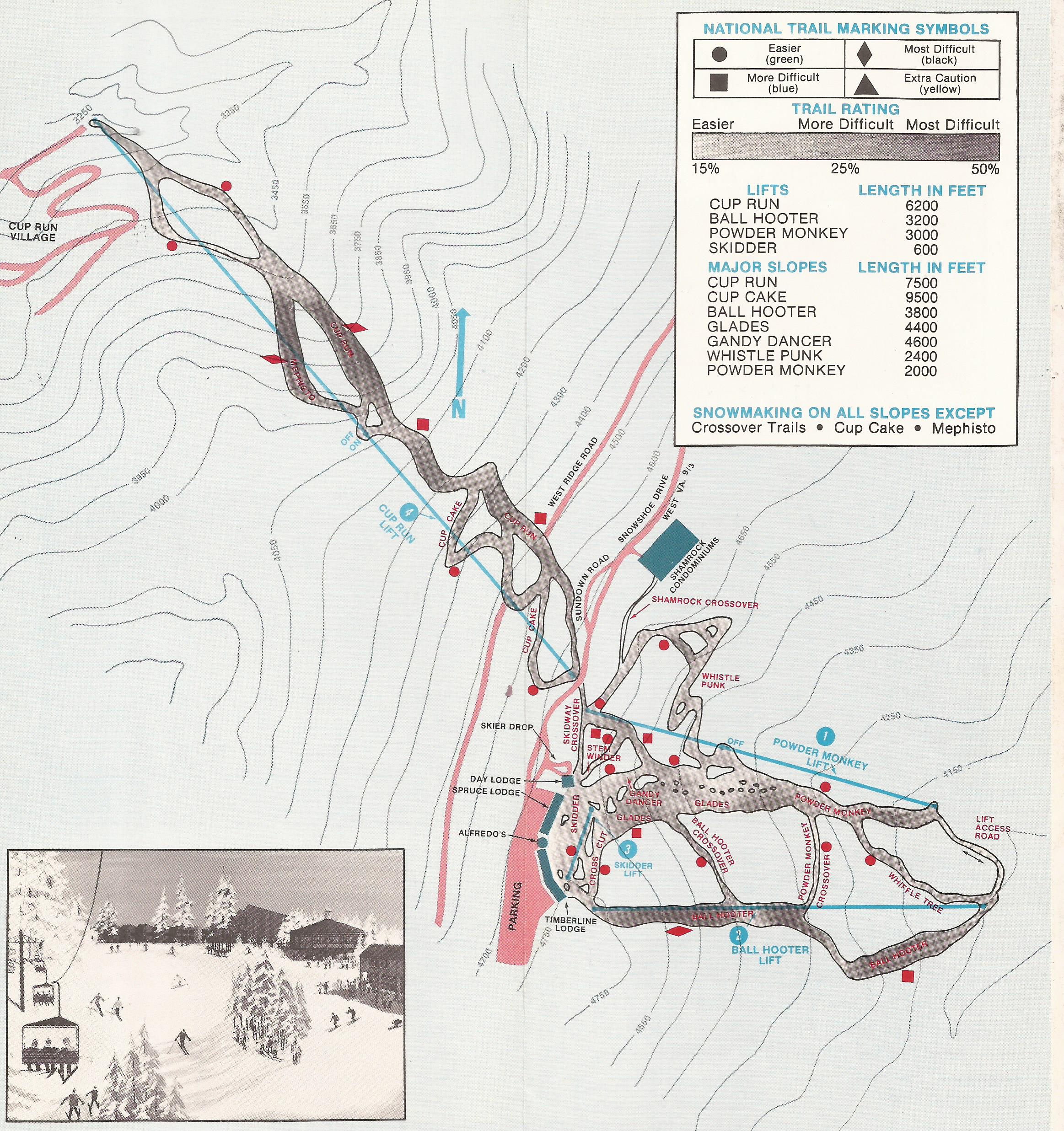
Is Cup Run really 1.5 miles long? I have some interesting measurements. This believes it to be 7500 feet long. THis is from 1976. So Im sure they were just guessing back then. I guess cup cake could be what makes up most of cup run today since it is closer to that distance. Or maybe they cut a new run when they added the other p?
More historical ski maps from WV can be found from this link https://skimap.org/Regions/view/323
US historical ski maps here https://skimap.org/Regions/view/187
Anyone see anything interesting or fun when looking at the old maps?
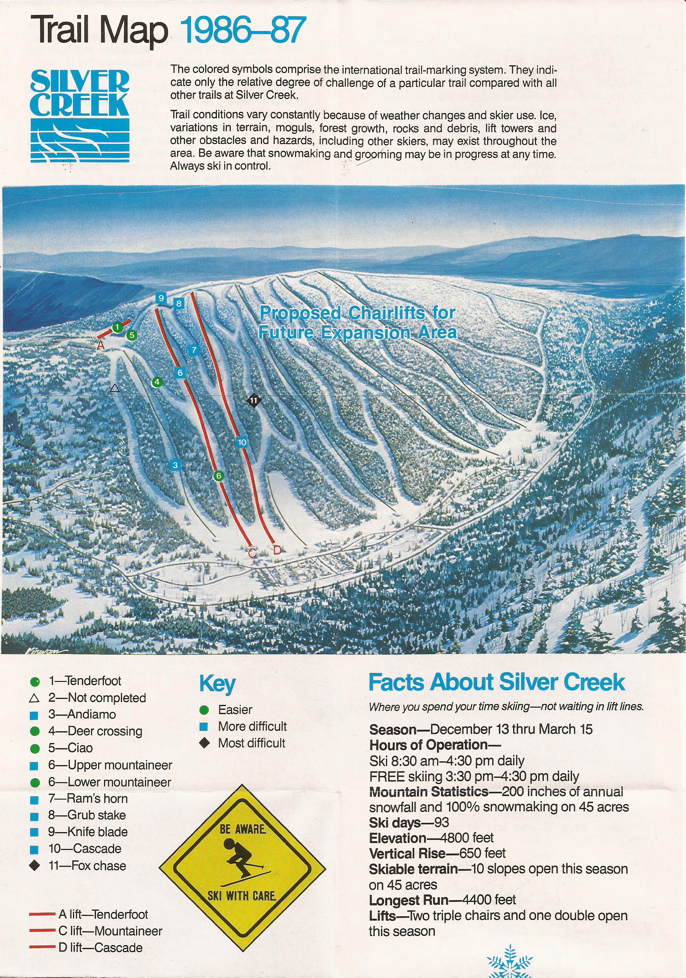
For example, apparently silver creek gets 200" of snow per year, and used to have free skiing from 3:30 to 4:30 daily. 1986 must have been a crazy time. Also check out the slogan. It is still true today!
totally fun, i love this stuff.
Remnants of cup cake are still there - a few turns back and forth under the lift line just before the mid station. I don't think it ever had snowmaking and eventually with Sheas Revenge they abandoned it but you can still ski it often.
I've never seen that Silver Creek map! It is totally messed up, you can only recognize about half the slopes and they have all that development at the base and totaly different slope design in the east part. It looks so great until you realize it is only 650 vert at best, then you say yeah it would never have worked. I wish I had seen what they actually did have back then.
Is the mid station on the Western Express lift ever used? When was that lift built?
When the Western express lift replaced the previous fixed chair, the mid station was deactivated.

The mid station was actually built after the express lift...but I suspect with new snow making we will not see it used. But I think the basic idea is it operates like a fixed grip lift when in use.
hoyadrew wrote:
Is the mid station on the Western Express lift ever used? When was that lift built?
Interesting, you answered my next question, thanks.
So I was curious as to when the lift was built and when they re-added the mid station. As The Colonel stated the western express was built without the midstation and it was added back in 2008 as the above article stated.
Google actually brought me to one of Scott's articles on the discussion on lift construction at Snowhoe if you are interested.http://www.dcski.com/articles/view_article.php?article_id=870&mode=search
It used to be part of their advertising that Cupp run was designed by Jean Claude Killy. Any truth to that?
Denis wrote:
It used to be part of their advertising that Cupp run was designed by Jean Claude Killy. Any truth to that?
He was somewhat active in the region. Appalachian Mountain Ski Area has photos on the lodge of Killy there in the early 70s and touts that he was one of the ski school er umm I mean French Swiss Ski College directors back then...
During the 1968 Winter Olympics, Jean-Claude Killy won all three Gold Medals for France in the men’s events. In the same events, the Swiss skiers were close on Killy’s tail. Since Killy’s feat, no alpine ski racer has won three gold medals in a single Olympics.
The ski college adapted the best elements from the techniques of the two nationalities and thus the name, French-Swiss, couldn’t have fit any better.
By the early 1970's, Killy was a director of the college and shared much of his knowledge and expertise with Cottrell over a three year period.
http://skifrenchswiss.com/history-pd-47.php
So was the mid station ever used at all?
Yes, prior to the fixed grip chair being replaced by the high speed quad servicing the Western Territory. And Yes, JCK did help design Cupp Run.
The Colonel aka Morgan B
How did Cupp Run get its name? Old logging and related railroad terminology is the basis for the trail names at Snowshoe, so what is the background for "Cupp"?
The Colonel. aka MorganB
I love this history too. You have to have permission to use someone's name?
I wonder what the "Cupp Run Village" is on that map? Also, I just noticed it seems like the trails are shaded - darker is more difficult, lighter lis less difficult. That's pretty cool.
Is there any talk of expanding the terrain on the Western Territory? The vertical in the basin area just isn't sufficient.
Off the back of the helicopter pad at the top of the world there used to be a slope named hawthorne that dropped over that way. It closed and they moved the lift. But the trails are still cut back there if you want to earn a turn or two.
I think the issue with expanding the terrain has something to do with a salamander that they don't want to mess up.
eggraid wrote:
Maybe the change was to simply distinguish the ski run from the stream.I love this history too. You have to have permission to use someone's name?
I wonder what the "Cupp Run Village" is on that map? Also, I just noticed it seems like the trails are shaded - darker is more difficult, lighter lis less difficult. That's pretty cool.
AndyGene wrote:
Off the back of the helicopter pad at the top of the world there used to be a slope named hawthorne that dropped over that way. It closed and they moved the lift. But the trails are still cut back there if you want to earn a turn or two.
I think the issue with expanding the terrain has something to do with a salamander that they don't want to mess up.
I've heard about the endangered salamander too. That's what I understand is preventing any expansion.
eggraid wrote:
I've heard about the endangered salamander too. That's what I understand is preventing any expansion.
See link above for some detail
This part is kind of cool:
It is the only described vertebrate species in the state that is found entirely within West Virginia. The entire range of this species is 935 square miles, the approximate area of Kanawha County.
This salamander occurs in the high mountains of east central West Virginia from Backbone Mountain, Tucker County in the north to Thorny Flat, Pocahontas County in the south. It is generally found above 3,500 feet, however in the northern part of its range it extends down to 2,640 feet.
The lots on Westridge must have completed and passed a salamander study before building. Not heard of any not passing but I guess it could happen. Might have to go look for one this spring/summer.
hoyadrew wrote:
Is there any talk of expanding the terrain on the Western Territory? The vertical in the basin area just isn't sufficient.
I met with a SS rep last season and he hinted that a re-build of Hawthorne being on their "plans" along with many other expansion projects. He followed up with the fact they sell out beds every weekend (remember...last season) so to fund expansion requires more revenue. Revenue comes from traffic...either increase price or increase # of beds. The village and surrounding ridge area real estate are pretty well taken. Where the next real estate deal happens will be an indicator of trail expansion imo.
While I like the idea of WT expansion, I also would consider expanding off of Flying Eagle just as the '86 map depicts or make it hike access to glade and semi-glade only trails, or something inbetween. Looks like the terrain feeds into Flying Eagle so it wouldn't require an additional lift...just trail cutting/thining. Think mini Vail's blue-sky basin. Yeah it's only 600' but that's perfect for east-coast glade runs with varying pitches.
Great maps.
That map makes me wonder how SS gets their 1500' claim?
camp wrote:
Great maps.
That map makes me wonder how SS gets their 1500' claim?
You got me thinking so I looked at my ski tracks from Jonas storm. The lift rides were consistently 1450 - 1470 on all my runs over there.
Not that ski tracks is the be all end all but the numbers are close and consistent.
that is like totally normal roundup in the ski industry. check any place against the maps and you get about that much error or more.
pagamony wrote:
that is like totally normal roundup in the ski industry. check any place against the maps and you get about that much error or more.
Well, I guess BlueDon was getting about 1500' on his lift rides. And looking closer at that map I see the top looks around 4800' and the bottom 3250'
Actually, impressed with Ski Tracks, based on the published data for the original lift.
http://www.skilifts.org/old/install_na1974.htm
I'll give them the round up.
Sorry that data was for the original lift, the new lift is 1,460.