Does anyone know any places that are clear of vegitation in souther pa. I know that big mnt (15 mins north of whitetail) has an area that is pretty much a snow field. I heard that by the summit there is an area that is reletivly clear of plants near the summit at 2,400. Can anyone confirm this?
Ant man...u r a young dude obviously with a wild imagination and energy + desire...been there done that Bud....those lowland..kinda big looking mtns look really appealing but u would be better off with ur over passes close to home..for real dude..it never works out the way u want..too much trash..too little snow to work with...when there is a big snow its usually too much..u need to just head west my man...West by God Virginia...the WV Alpps...The Canaan area is soooo laid back and has sooo much snow..plus all the grooming and trail traffic that it has makes life easy for ya...getting there is so much easier now with a super Hiway taking u to the northern exposure town of Davis than it was when Me and my buddies were hitting those twisty switchbacks in some knarly ass wx....its closer than u think...and it will fix all those demons ..good friendly goblins ,,but misinformed..it will be fixed with just one trip to Black water falls after a fresh snowfall...u will forget those in the distance mtns that look sooooo appealing...u will have found ur Nordic home...Peace....
Antoine wrote:
Does anyone know any places that are clear of vegitation in souther pa.
Rarely do I say agree with anything fishnski says ;), but I know that Canaan is the spot.
That said, I live in Franklin County and am always looking for the same as you. I've found a few decent glades that I ski with enough base, and some fast(ish) twisty doubletracks as well. I wish I knew of that big mtn snowfield north of Whitetail that you mentioned. There are designated XC Ski Trails in the state forests (which are pretty boring) but they allow me to access the woods and other steeper spots. Have yet to find a steep enough snow field though. ANother benefit to the state forest spots is the roads are plowed to the trailhead, which is needed if there's enough snow to ski. One of the spots is on the top of Tuscarora north of Wt where a plowed state route leads right to the parking lot. Sounds like I'm looking for the same things you are, and have been for years. I ski these things after work or when I can't travel far on a weekend. If I could travel, I'd go toward Blue Knob or Davis/Canaan.
Tuscacora mnt in other words. It's the county hight point and has several cleanish meadows. I would love to put a resort on that mountain. Just need to find interested investors and permission from the state. It's the mountain that rises over mconellsburg/fort loudon.

fishnski wrote:
"Rarely do I say agree with anything fishnski says ".......ouchy...........let me go get a drink ill be back....my feelings are hurt...
I almost spit my [strong tasty beer] drink out. OK, a couple of those I agree with.
Antoine, I XC/tele ski on Tuscarora Mtn, haven't seen any big sloped meadows (other than utility lines), and will look first chances I get. I've mostly found some fast-ish doubletracks that allow an occassional turn. I turn north from Route 30 at the top of the ridge, then park along Tower Road. It's all downhill from there.
Antoine wrote:
Tuscacora mnt in other words. It's the county hight point and has several cleanish meadows. I would love to put a resort on that mountain. Just need to find interested investors and permission from the state. It's the mountain that rises over mconellsburg/fort loudon.
Seen this?
Yes actually. That kinda led to he thought that somone may have done back country skiing there. The resort got is demise from its tinny vert and low elevation. Top of the mnt its on is significantly colder.
camp wrote:
fishnski wrote:
"Rarely do I say agree with anything fishnski says ".......ouchy...........let me go get a drink ill be back....my feelings are hurt...I almost spit my [strong tasty beer] drink out. OK, a couple of those I agree with.
OK..I see there is a little hope here..I know I can be a stupid dickhead but im trying to get better...
Hey Antoine..what about that Mtn near liberty that they were trying to turn into a ski area but fell thru...what is that ridge looking like?...if I remember right it had almost 1000 vert....
Since I am " young and clueless" i was not born at the time of construction. Analyzing the old arial pics is not posible because the two ridges are identical amd the farm that is visible to the east is not there on google earth. I remeber looking up tools of that mountain. I think its either derr hill or piney mnt. On the article it says "1710" foot mountain. Neither is that hight the closest one is roundtop a mountain to the west. All i need to know is if its a north or south casing mnt because if its Facing south we are looking 1k+ vert!
College Mountain is all grown up now, the runs are stands of poletimber birch. It is also extremely rocky, but it did/ does face north. During the Civil War it was used to signal one of the roundtops at Gettysburg. I have skied around Michaux State Forest, mostly pipelines and in areas with clean understory. Its really tough to get many backcountry days in around here, the snow goes quick and comes infrequently. I would urge you to look west to higher elevations along the eastern continental divide. The snow there is more common and of better quality. Check out Whitegrass, lots of manicured glades.
yotestang wrote:
..Its really tough to get many backcountry days in around here, the snow goes quick and comes infrequently. I would urge you to look west to higher elevations along the eastern continental divide. The snow there is more common and of better quality. Check out Whitegrass, lots of manicured glades.
So true. I found some promising terrain near Blue Knob last season that I hope to hit again soon. The top of Route 869 as it goes over the ridge / county line. Much more snow there than in Franklin Co.
The reason i am drawn to this mnt is its elevation (compared to relative surroundings) because lets face it the only reason BK was chosen as a mnt because of its elevation ( and snowfall). I dont know I probably have way to much of an attachment to this mnt. Haha not a good thing as far as I am concerned
Going to take some pictures up at the top in the comming week. Going to try to hike down and get some temp measurements and vert. Also going to look good spots. Guessing the northen slopes ill be better
I am going to go take some pic this week end to show some of the places i found might even ski some. Really exited because of the scenery will be so much better with both valley covered in snow. Going to take one of my temperature guns and compare the temps from there to WT. Th temp gun is a nubee gun really recommend it its in sale for 20 from 70, it's the same that was used during the Ebola outbreak.
I have to say I was skeptical i would be able to ski it but I did. Snow pack was around six inches @ 2200 feet skied down around 300 feet along the fore trail. Skins would be a nice addition for that. The mountain also has something for you fish (no its weather related)...
I am going to be doing extrnsive hicking around tower road this summer. But already i can tell that the fore trail is pretty good.
Ephemeral Lines yesterday on some of the trails Antoine and I have been talking about here I don't see much reason to keep any of this a secret (sorry). I think a few more sets of skis and eyes would be useful up there. It's not like its crowded or anything. I only had 2 hours, and I didn't have time to hit that trail you named to me Antoine, but I agree with you, it would be a good one. Probably the steepest one, and either skins or a shuttle would be ideal.


I took a drive today to tower road today, with areas with over 12 inch base! (@2400 ft) where it only got to around 43 today (valley was 55) I also drove augwick road and the fore trail seems to be very interesting around the Herapin turn. The upper part is pretty steep but has rocks, the part bellow the road is interesting. Seems like a natural half pipe with rock outcropings. Near cowans gap plenty of nice places but the greenbariers are to large. Also camp Stay safe looks like you guys might get a flood on tues!
Antoine wrote:
... the fore trail seems to be very interesting around the Herapin turn. The upper part is pretty steep but has rocks, the part bellow the road is interesting. Seems like a natural half pipe with rock outcropings.
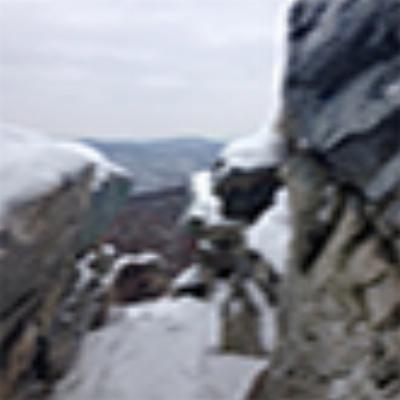
Hiked Lockard and Fore Trails today. Here's a pic on Fore Trail above the road. Pretty narrow and some is pretty rocky. Richmond Trail will be my next hike or bike. The bottom of Richmond sure looks wide open. Kinda sad that the pics I posted above were just one week ago.

We may of still had some snow there. But the Pocono's was where it was at this year. Maybe next year...
So much great terrain by Lincoln highway. But it faces dead on south. There is some good terrain down by dogwood drive, by the old power line and in and around those trees. But its on private property.
Looking at 6+ inches in metal twp, higher amounts in the mnts
I hiked tk the boulder feild in the TT from cowans gap. I saw a nice slide throught the switchbacks with northern aspect. And then the big rock outcropings along the ridge line (we would need a hell of a winter for that to ski well) the most promising thing was the small slide but again it was killed by the mnt laurel/greenbariers
I hiked the entire TT in PA this spring. The most promising two areas that I saw were Big Mountain (approx. 2500ft). There is a north facing knob off of Tower Road which drops down toward the shelter area and there are some logging roads in that area. The second was the Tuscarora State Forest area further north. There are several ridgelines up there that top out well over 2,000 feet, with trails that drop off roads on the top of these ridgelines. Two areas are the Hemlock Road area and the backside of Blue Mountain off of Three Square Hollow Road. There is a good forest map on the PA DCNR website.
KeithT wrote: The second was the Tuscarora State Forest area further north. There are several ridgelines up there that top out well over 2,000 feet, with trails that drop off roads on the top of these ridgelines. Two areas are the Hemlock Road area and the backside of Blue Mountain off of Three Square Hollow Road.
I have always looked for a pine forest similar to those out west/ the north east. I know there is one on mount port crayon in wv, but how are these trees?

Join the conversation by logging in.
Don't have an account? Create one here.