Potomac Highlands, West Virginia: Biking and Hiking Report
3
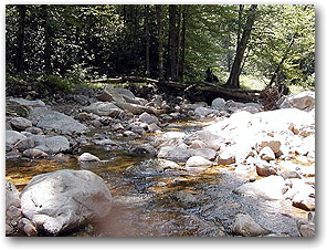
Barreling down an abandoned railroad grade at 18 miles per hour on a mountain bike almost felt like skiing. The full-suspension of the bike absorbed the bumps, making the descent fluid, effortless, and quiet. These feelings of transcendence were intensified by the solitude of the ride. Darina and I did not see another rider for the entire 10 miles of Canyon Trail. Our only companions were the forest birds.
The Canyon Trail, not to be confused with the Canyon Rim Trail, begins in Douglas and ends in Hendricks. It follows a railroad grade near the base of the Blackwater Canyon. The trail begins near the Douglas waterfall and slowly winds its way down the canyon, dropping 1,100 feet over its 10 mile course. Most of the path is covered by a green canopy of trees, making the ride cool and comfortable even on the hottest days.
In the near future, West Virginia intends improve the Canyon Trail and link it with the Elkins-Parsons rail-to-trail conversion. When this occurs, the trail will be suitable for most hybrids and trekking bikes, but for now mountain bikes with front end suspension are recommended due to the rocky and rutted nature of the trail.
With the right bike, lower intermediate mountain bikers should have no problem completing this trail. The only tough part of the ride was the trip home. It took us less than an hour to get to Hendricks, but the ride back took two with stops included. The grade of the Canyon Trail is not nearly as steep as the Canyon Rim trail, but it still requires the a steady, 10 mile long ascent. The climb, though, allowed me to soak in some of the canyon views I had missed during the descent.
Having satisfied my yen to go downhill at high speeds, we opted to go hiking the next day. Darina and I, joined by another couple, chose a 6 mile trail called the South Prong trail in the Flatrock Plains area of the Monongahela National Forrest. The trail begins just before the Dolly Sods picnic grounds and ends at a trailhead further down FR-19 towards Laneville. We parked cars at both trailheads so we wouldn’t need to make a 12 mile roundtrip hike. We also started at the upper trailhead and hiked down, a decision which spared us a grueling 1,000 foot climb.
The Forest Service has invested much time and effort recently in improving the trail. It has removed branches, surfaced heavily used areas with crushed rock, and built boardwalks over wetland sections. What used to be a muddy slog is now a pleasant walk that can even be done in sneakers.
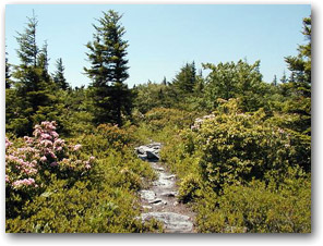
The walk was made even more pleasant by the presence of bush after bush of blooming Rhododendrons. The flowers rivaled those at the National Arboretum yet this was not a botanical garden, but a natural paradise. How fortunate we are to have places like the Flatrock Plains.
Trees have begun to return on the Flatrock Plains, obscuring some of the views of the Allegheny Front (the Eastern Continental Divide) for which the South Prong Trail was once famous. Nonetheless, there are still some excellent vista points just before the trail crosses Forrest Road 70. Gazing down the 2,000 foot drop of the front, I am always amazed at the differences between the trees on either side of the divide. To the west, Spruce trees abound, but east of the divide, deciduous trees dominate the landscape. For skiers, the divide is more than just a natural wonder; it is the dividing line between the Snow Belt and the rest of the Mid-Atlantic.
Resorts west of the divide such as Snowshoe, Timberline, and Seven Springs receive far more natural snow than those residing east of it. The temperature west of the line is on average ten degrees cooler -; a real blessing on what turned out to be a warm weekend in the Mid-Atlantic. While temps in DC reached the mid-90s over the weekend, the Flatrock Plains, at 3500 feet above sea level, never got much hotter than 78 degrees.
From the Flatrock Plains, the trail descends 1,000 feet along the South Fork of the Red Creek. Much of the trail follows an abandoned rail grade, but on occasion, the trail meanders so it is wise to follow the blue blazes carefully.
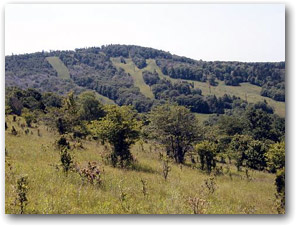
On Sunday, most us needed to get home quickly so we chose to hike the Bald Knob trail, a short hike in the Canaan State Park. Bald Knob lies just north of the Canaan Valley Ski resort. Its position allows hikers to eliminate 850 feet of uphill vertical by taking a chair lift to the top of nearby Weiss Knob and starting the hike from there. Being pressed for time, we chose the quick and easy route.
The $4.25 chair ride proved to be delightful. It allowed our group to catch a glimpse of the Canaan Valley Resort during the off season. Foliage, green grass, deer, and playful groundhogs give the resort an entirely different flavor in the summer. The hills are indeed alive.
The hike starts out in a wooded area across of the chair lift debarkation point. It then follows a gas pipeline right-of-way to the top of Bald Knob. From there, it meanders through alpine meadows and finally ends at the Canaan Valley overflow lot. Bald Knob offers some of the finest views of Canaan Valley. The meadows beneath it have a truly European feel. If you close your eyes, you might think for a minute that you were in the Alps. “Doe, a deer,” -; You get the idea.
The meadows below Bald Knob are also a favorite destination for backcountry, and telemark skiers. One day I hope to return to these slopes when there is snow. As we all know, for skiers and snowboarders, hiking is the ultimate opportunity to scout out future backcountry adventures.
To locate the Canyon and the South Prong trails:
The Canyon Trail: take Douglas Road (CR 27) from Thomas, WV through the village of Coketon. Just after Coketon but before Douglas, take a left hand turn on FS-115. Park just before the gate. Don’t confuse this trail with the Canyon Rim trai (FR-18)l. If you have driven through Douglas, you have gone too far.
South Prong Trail: The upper (East) trailhead is .4 of a mile West of the Dolly Sods Picnic Area on FR-19. To get to FR-19, follow SR-32 south from the Canaan Valley ski resort, and take a left on SR-45. Follow SR-45 to Laneville. FR-19 begins just after you cross the Red Creek.
Great article John! I can't wait till the day that I live in the mountains, and don't have to drive ten hours to them! Sounds like the summer up yonder is going great, it's not too bad here either, just a little warm. I'm going to play with the Army Rangers for a week in late July. Our venture crew is going to "Ranger Camp"; if ya'll want, I can write up a report on my climbing adventures/training in GA with the Rangers.
Jarrett:
Try to enjoy the Ranger program (if that is possible). There's a National Guard Special Forces detachment in WV that occasionally does mountain warfare training in the Dolly Sods. You might want to try and hook up with these guys if you get a chance. Timberline let the whole unit ski for free last year. Also, e-mail Scott about the rock climbing article.
John
Thanks for the info John! I was at a gym all afternoon, I was surprised at how beneficial bouldering is! Ranger camp should be loads of fun, but lots of yelling!